Alianza Cristiana elevation
Alianza Cristiana (Loreto, Datem Del Marañon), Peru elevation is 173 meters and Alianza Cristiana elevation in feet is 568 ft above sea level [src 1]. Alianza Cristiana is a seat of a third-order administrative division (feature code) with elevation that is 2148 meters (7047 ft) smaller than average city elevation in Peru.
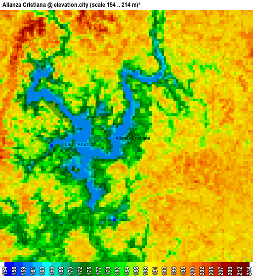
Below is the Elevation map of Alianza Cristiana, which displays elevation range with different colors. Scale of the first map is from 154 to 214 m (505 to 702 ft) with average elevation of 187.1 meters (=614 ft) [note 1]
These maps also provides idea of topography and contour of this city, they are displayed at different zoom levels. More info about maps, scale and edge coordinates you can find below images.
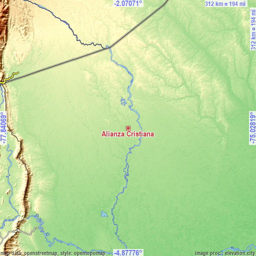
| \ | Map #1 | Topo.Map |
| Scale [m] | 154..214 m | × |
| Scale [ft] | 505..702 ft | × |
| Average | 187.1 m = 614 ft | × |
| Width | 9.75 km = 6.1 mi | 312.1 km = 193.9 mi |
| Height | 9.75 km = 6.1 mi | 312.1 km = 193.9 mi |
| ↑Max Latitude | -3.431414° | -2.07071° |
| Latitude at center | -3.47528° | -3.47528° |
| ↓Min Latitude | -3.519143° | -4.87776° |
| ← Min Longitude | -76.478385° | -77.84069° |
| Longitude center | -76.43444° | -76.43444° |
| →Max Longitude | -76.390495° | -75.02819° |
Nearby cities:
Cities around Alianza Cristiana sort by population:
• Yurimaguas elevation 143 m
272 km,  172°
172°
• Lagunas 124 m
212.2 km,  156°
156°
• Barranca 165 m
153.3 km,  190°
190°
• Chiriaco 310 m
278.1 km,  227°
227°
• Parinari 118 m
253 km,  118°
118°
• Santa Cruz 164 m
241.2 km, 163°
• Concordia 118 m
219.7 km, 123°
• Jeberos 148 m
201.7 km,  175°
175°
• Saramiriza 148 m
162.9 km,  221°
221°
• Puerto Galilea 186 m
160.5 km,  246°
246°
• Trompeteros 128 m
157.3 km,  103°
103°
• San Lorenzo 146 m
150.3 km, 187°
Multilingual:
 En español:
Alianza Cristiana elevación 173 m.
 En France:
Alianza Cristiana élévation 173 m.
 Auf Deutsch:
Alianza Cristiana höhe über dem Meeresspiegel ist 173 m.

Sources and notes:
- [note 1] Map square and city borders are not equal. Map elevation data is calculated only from area inside that square.
- [src 1] Elevation data from geonames database provided with same terms of usage.
- [src 2] The elevation map of Alianza Cristiana is generated using elevation data from NASA's 3 arcsec (90m) resolution SRTM data.
- [src 3] Base (background) map © OpenStreetMap contributors tiles are generated by Geofabrik and OpenTopoMap.
Copyright & License:
This Alianza Cristiana Elevation Map is licensed under CC BY-SA. You may reuse any part from this page, if you give a proper credit by linking to this URL:
 More info on terms of use page.