San Lorenzo elevation
San Lorenzo (Loreto, Datem Del Marañon), Peru elevation is 146 meters and San Lorenzo elevation in feet is 479 ft above sea level [src 1]. San Lorenzo is a seat of a third-order administrative division (feature code) with elevation that is 2175 meters (7136 ft) smaller than average city elevation in Peru.
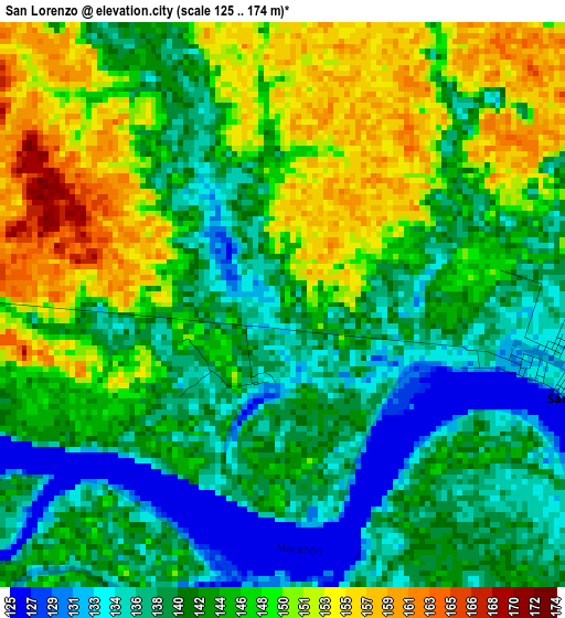
Below is the Elevation map of San Lorenzo, which displays elevation range with different colors. Scale of the first map is from 125 to 174 m (410 to 571 ft) with average elevation of 144 meters (=472 ft) [note 1]
These maps also provides idea of topography and contour of this city, they are displayed at different zoom levels. More info about maps, scale and edge coordinates you can find below images.
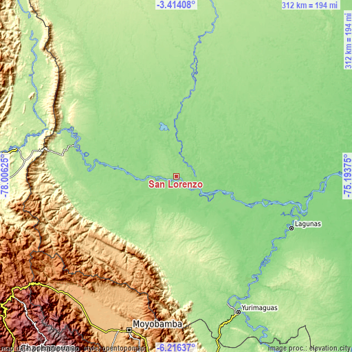
| \ | Map #1 | Topo.Map |
| Scale [m] | 125..174 m | × |
| Scale [ft] | 410..571 ft | × |
| Average | 144 m = 472 ft | × |
| Width | 9.74 km = 6.1 mi | 311.6 km = 193.6 mi |
| Height | 9.74 km = 6.1 mi | 311.6 km = 193.6 mi |
| ↑Max Latitude | -4.772878° | -3.41408° |
| Latitude at center | -4.81667° | -4.81667° |
| ↓Min Latitude | -4.860459° | -6.21637° |
| ← Min Longitude | -76.643945° | -78.00625° |
| Longitude center | -76.6° | -76.6° |
| →Max Longitude | -76.556055° | -75.19375° |
Nearby cities:
Cities around San Lorenzo sort by population:
• Moyobamba elevation 877 m
141.5 km,  196°
196°
• Yurimaguas 143 m
131.7 km,  156°
156°
• Lagunas 124 m
112.1 km,  114°
114°
• Barranca 165 m
8.6 km,  257°
257°
• Posic 824 m
147 km,  205°
205°
• Calzada 849 m
144.7 km, 200°
• Naranjos 974 m
143.1 km,  223°
223°
• Yuracyacu 816 m
142 km, 209°
• Bajo Naranjillo 876 m
140.9 km, 217°
• Santa Cruz 164 m
120.4 km,  132°
132°
• Saramiriza 148 m
94.6 km,  287°
287°
• Jeberos 148 m
62.6 km,  145°
145°
Multilingual:
 En español:
San Lorenzo elevación 146 m.
 En France:
San Lorenzo élévation 146 m.
 Auf Deutsch:
San Lorenzo höhe über dem Meeresspiegel ist 146 m.

Sources and notes:
- [note 1] Map square and city borders are not equal. Map elevation data is calculated only from area inside that square.
- [src 1] Elevation data from geonames database provided with same terms of usage.
- [src 2] The elevation map of San Lorenzo is generated using elevation data from NASA's 3 arcsec (90m) resolution SRTM data.
- [src 3] Base (background) map © OpenStreetMap contributors tiles are generated by Geofabrik and OpenTopoMap.
Copyright & License:
This San Lorenzo Elevation Map is licensed under CC BY-SA. You may reuse any part from this page, if you give a proper credit by linking to this URL:
 More info on terms of use page.