Yurimaguas elevation
Yurimaguas (Loreto, Provincia de Alto Amazonas), Peru elevation is 143 meters and Yurimaguas elevation in feet is 469 ft above sea level [src 1]. Yurimaguas is a seat of a third-order administrative division (feature code) with elevation that is 2178 meters (7146 ft) smaller than average city elevation in Peru.
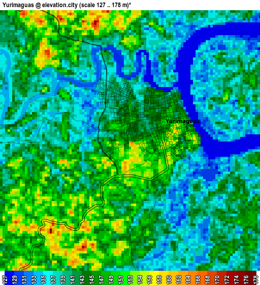
Below is the Elevation map of Yurimaguas, which displays elevation range with different colors. Scale of the first map is from 127 to 178 m (417 to 584 ft) with average elevation of 141.9 meters (=466 ft) [note 1]
These maps also provides idea of topography and contour of this city, they are displayed at different zoom levels. More info about maps, scale and edge coordinates you can find below images.
| \ | Map #1 | Map #2 | Topo.Map |
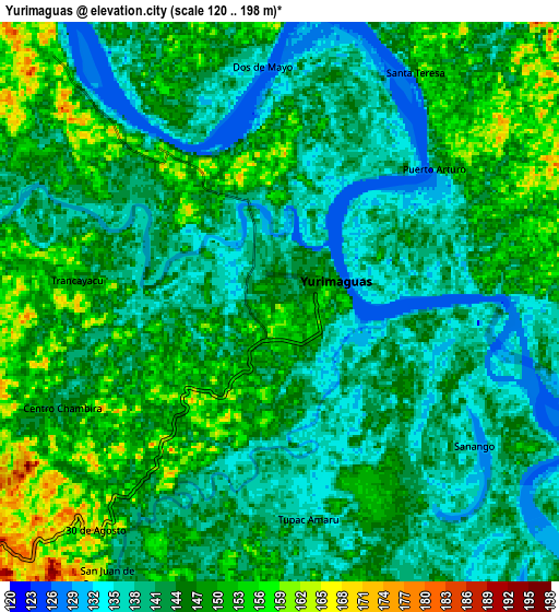
| Scale [m] | 127..178 m | 120..198 m | × |
| Scale [ft] | 417..584 ft | 394..650 ft | × |
| Average | 141.9 m = 466 ft | 144.3 m = 473 ft | × |
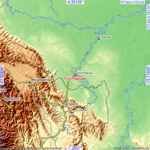
| Width | 9.72 km = 6 mi | 19.44 km = 12.1 mi | 311 km = 193.2 mi |
| Height | 9.72 km = 6 mi | 19.44 km = 12.1 mi | 311.1 km = 193.3 mi |
| ↑Max Latitude | -5.858096° | -5.814378° | -4.50139° |
| Latitude at center | -5.90181° | -5.90181° | -5.90181° |
| ↓Min Latitude | -5.945521° | -5.989228° | -7.2987° |
| ← Min Longitude | -76.166285° | -76.210231° | -77.52859° |
| Longitude center | -76.12234° | -76.12234° | -76.12234° |
| →Max Longitude | -76.078395° | -76.034449° | -74.71609° |
Nearby cities:
Cities around Yurimaguas sort by population:
• Lamas elevation 814 m
73.1 km,  218°
218°
• Chazuta 214 m
74.4 km,  181°
181°
• Cuñumbuqui 232 m
78.4 km,  210°
210°
• Shapaja 207 m
77 km,  191°
191°
• Tarapoto 271 m
71.9 km,  201°
201°
• Jeberos 148 m
71 km,  345°
345°
• Navarro 160 m
63.2 km,  139°
139°
• San Antonio 951 m
57.5 km, 205°
• Santa Cruz 164 m
52.9 km,  42°
42°
• Pelejo 143 m
48.7 km, 136°
• Barranquita 163 m
42.2 km,  163°
163°
• Shucushuyacu 172 m
32.7 km,  112°
112°
Multilingual:
 En español:
Yurimaguas elevación 143 m.
 En France:
Yurimaguas élévation 143 m.
 Auf Deutsch:
Yurimaguas höhe über dem Meeresspiegel ist 143 m.

Sources and notes:
- [note 1] Map square and city borders are not equal. Map elevation data is calculated only from area inside that square.
- [src 1] Elevation data from geonames database provided with same terms of usage.
- [src 2] The elevation map of Yurimaguas is generated using elevation data from NASA's 3 arcsec (90m) resolution SRTM data.
- [src 3] Base (background) map © OpenStreetMap contributors tiles are generated by Geofabrik and OpenTopoMap.
Copyright & License:
This Yurimaguas Elevation Map is licensed under CC BY-SA. You may reuse any part from this page, if you give a proper credit by linking to this URL:
 More info on terms of use page.