Chazuta elevation
Chazuta (San Martín, Provincia de San Martín), Peru elevation is 214 meters and Chazuta elevation in feet is 702 ft above sea level [src 1]. Chazuta is a seat of a third-order administrative division (feature code) with elevation that is 2107 meters (6913 ft) smaller than average city elevation in Peru.
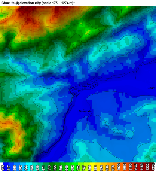
Below is the Elevation map of Chazuta, which displays elevation range with different colors. Scale of the first map is from 175 to 1274 m (574 to 4180 ft) with average elevation of 414.4 meters (=1360 ft) [note 1]
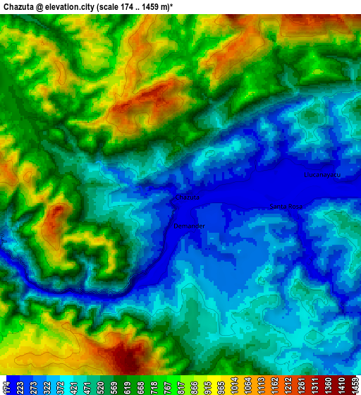
These maps also provides idea of topography and contour of this city, they are displayed at different zoom levels. More info about maps, scale and edge coordinates you can find below images.
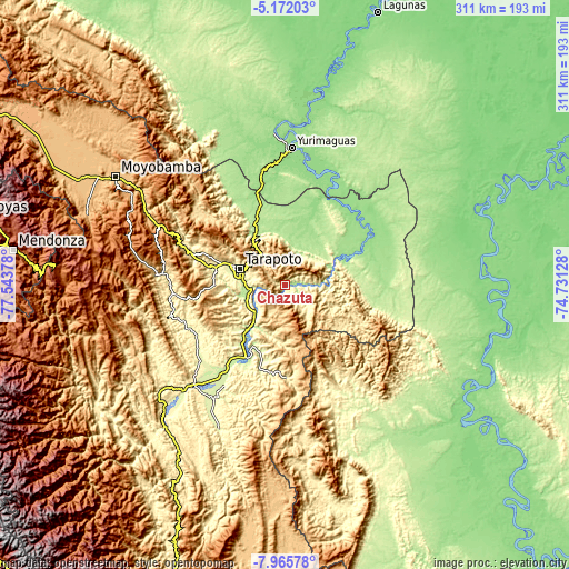
| \ | Map #1 | Map #2 | Topo.Map |
| Scale [m] | 175..1274 m | 174..1459 m | × |
| Scale [ft] | 574..4180 ft | 571..4787 ft | × |
| Average | 414.4 m = 1360 ft | 579.3 m = 1901 ft | × |
| Width | 9.71 km = 6 mi | 19.42 km = 12.1 mi | 310.6 km = 193 mi |
| Height | 9.71 km = 6 mi | 19.42 km = 12.1 mi | 310.7 km = 193.1 mi |
| ↑Max Latitude | -6.527211° | -6.483549° | -5.17203° |
| Latitude at center | -6.57087° | -6.57087° | -6.57087° |
| ↓Min Latitude | -6.614525° | -6.658176° | -7.96578° |
| ← Min Longitude | -76.181475° | -76.225421° | -77.54378° |
| Longitude center | -76.13753° | -76.13753° | -76.13753° |
| →Max Longitude | -76.093585° | -76.049639° | -74.73128° |
Nearby cities:
Cities around Chazuta sort by population:
• Pucacaca elevation 216 m
38.5 km,  215°
215°
• Cuñumbuqui 232 m
38.4 km,  279°
279°
• Barranquita 163 m
36.4 km,  21°
21°
• San Antonio 951 m
32.7 km,  314°
314°
• Buenos Aires 213 m
32.2 km, 220°
• Pilluana 213 m
28.5 km, 216°
• Tres Unidos 275 m
28.1 km,  201°
201°
• Tarapoto 271 m
26.3 km,  287°
287°
• Juan Guerra 207 m
21.3 km,  266°
266°
• Utcurarca 209 m
19.4 km,  238°
238°
• Sauce 611 m
15.9 km,  212°
212°
• Shapaja 207 m
13.9 km, 265°
Multilingual:
 En español:
Chazuta elevación 214 m.
 En France:
Chazuta élévation 214 m.


Sources and notes:
- [note 1] Map square and city borders are not equal. Map elevation data is calculated only from area inside that square.
- [src 1] Elevation data from geonames database provided with same terms of usage.
- [src 2] The elevation map of Chazuta is generated using elevation data from NASA's 3 arcsec (90m) resolution SRTM data.
- [src 3] Base (background) map © OpenStreetMap contributors tiles are generated by Geofabrik and OpenTopoMap.
Copyright & License:
This Chazuta Elevation Map is licensed under CC BY-SA. You may reuse any part from this page, if you give a proper credit by linking to this URL:
 More info on terms of use page.