Lamas elevation
Lamas (San Martín, Provincia de Lamas), Peru elevation is 814 meters and Lamas elevation in feet is 2671 ft above sea level [src 1]. Lamas is a seat of a third-order administrative division (feature code) with elevation that is 1507 meters (4944 ft) smaller than average city elevation in Peru.
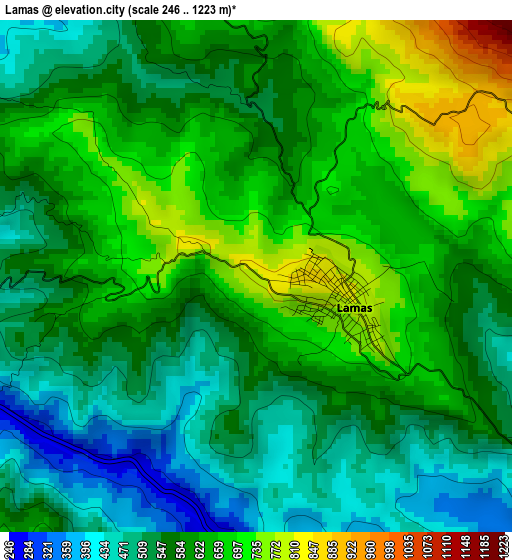
Below is the Elevation map of Lamas, which displays elevation range with different colors. Scale of the first map is from 246 to 1223 m (807 to 4012 ft) with average elevation of 592.9 meters (=1945 ft) [note 1]
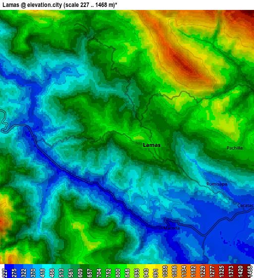
These maps also provides idea of topography and contour of this city, they are displayed at different zoom levels. More info about maps, scale and edge coordinates you can find below images.
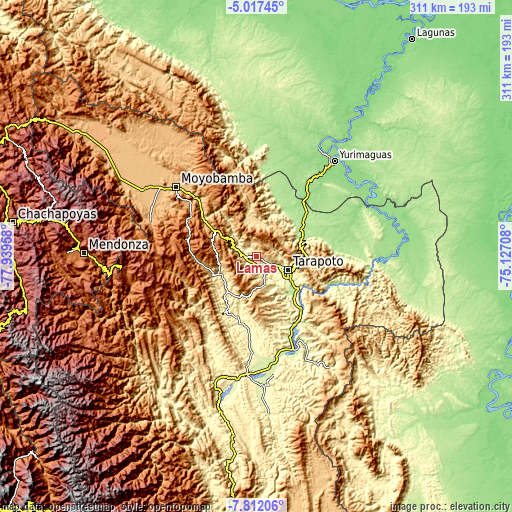
| \ | Map #1 | Map #2 | Topo.Map |
| Scale [m] | 246..1223 m | 227..1468 m | × |
| Scale [ft] | 807..4012 ft | 745..4816 ft | × |
| Average | 592.9 m = 1945 ft | 619 m = 2031 ft | × |
| Width | 9.71 km = 6 mi | 19.42 km = 12.1 mi | 310.7 km = 193.1 mi |
| Height | 9.71 km = 6 mi | 19.42 km = 12.1 mi | 310.8 km = 193.1 mi |
| ↑Max Latitude | -6.372998° | -6.329323° | -5.01745° |
| Latitude at center | -6.41667° | -6.41667° | -6.41667° |
| ↓Min Latitude | -6.460338° | -6.504003° | -7.81206° |
| ← Min Longitude | -76.577275° | -76.621221° | -77.93958° |
| Longitude center | -76.53333° | -76.53333° | -76.53333° |
| →Max Longitude | -76.489385° | -76.445439° | -75.12708° |
Nearby cities:
Cities around Lamas sort by population:
• Tabalosos elevation 1162 m
18.2 km,  294°
294°
• Sisa 375 m
27.9 km,  219°
219°
• Utcurarca 209 m
38.6 km,  135°
135°
• Shapaja 207 m
35 km,  121°
121°
• Santa Rosa 340 m
31 km,  197°
197°
• Roque 1805 m
29.5 km,  273°
273°
• Juan Guerra 207 m
29.1 km,  129°
129°
• Shatoja 414 m
23.9 km,  238°
238°
• San Antonio 951 m
21 km,  74°
74°
• Tarapoto 271 m
20.8 km, 116°
• Zapatero 281 m
13.4 km,  160°
160°
• Cuñumbuqui 232 m
12 km,  150°
150°
Multilingual:
 En español:
Lamas elevación 814 m.
 En France:
Lamas élévation 814 m.


Sources and notes:
- [note 1] Map square and city borders are not equal. Map elevation data is calculated only from area inside that square.
- [src 1] Elevation data from geonames database provided with same terms of usage.
- [src 2] The elevation map of Lamas is generated using elevation data from NASA's 3 arcsec (90m) resolution SRTM data.
- [src 3] Base (background) map © OpenStreetMap contributors tiles are generated by Geofabrik and OpenTopoMap.
Copyright & License:
This Lamas Elevation Map is licensed under CC BY-SA. You may reuse any part from this page, if you give a proper credit by linking to this URL:
 More info on terms of use page.