Moyobamba elevation
Moyobamba (San Martín, Provincia de Moyobamba), Peru elevation is 877 meters and Moyobamba elevation in feet is 2877 ft above sea level [src 1]. Moyobamba is a seat of a first-order administrative division (feature code) with elevation that is 1444 meters (4738 ft) smaller than average city elevation in Peru.
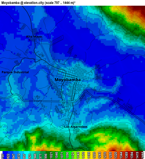
Below is the Elevation map of Moyobamba, which displays elevation range with different colors. Scale of the first map is from 797 to 1444 m (2615 to 4738 ft) with average elevation of 889.3 meters (=2918 ft) [note 1]
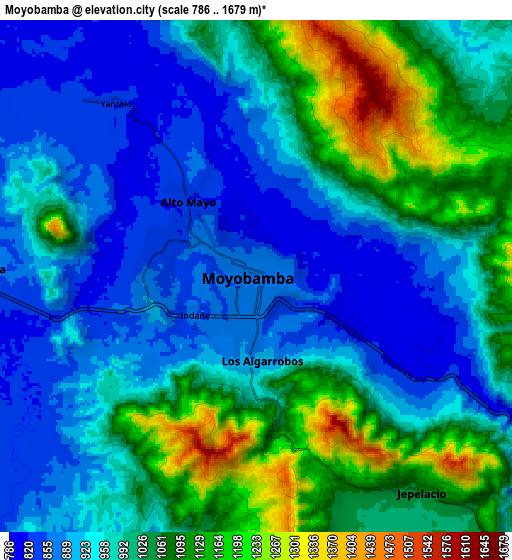
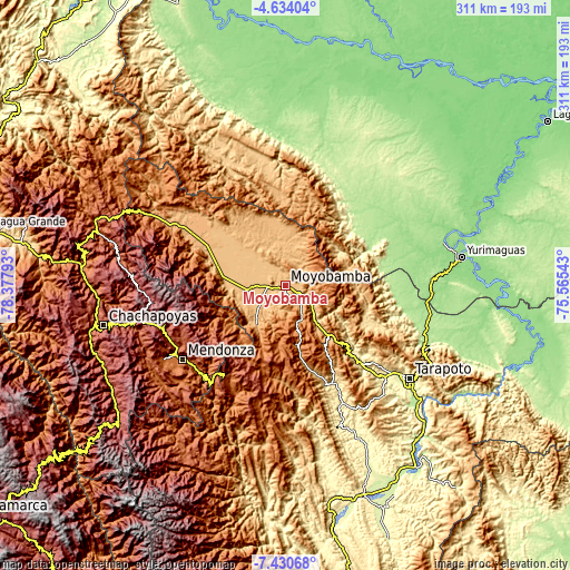
These maps also provides idea of topography and contour of this city, they are displayed at different zoom levels. More info about maps, scale and edge coordinates you can find below images.
| \ | Map #1 | Map #2 | Topo.Map |
| Scale [m] | 797..1444 m | 786..1679 m | × |
| Scale [ft] | 2615..4738 ft | 2579..5509 ft | × |
| Average | 889.3 m = 2918 ft | 989.9 m = 3248 ft | × |
| Width | 9.72 km = 6 mi | 19.44 km = 12.1 mi | 311 km = 193.2 mi |
| Height | 9.72 km = 6 mi | 19.44 km = 12.1 mi | 311 km = 193.2 mi |
| ↑Max Latitude | -5.990456° | -5.946749° | -4.63404° |
| Latitude at center | -6.03416° | -6.03416° | -6.03416° |
| ↓Min Latitude | -6.07786° | -6.121557° | -7.43068° |
| ← Min Longitude | -77.015625° | -77.059571° | -78.37793° |
| Longitude center | -76.97168° | -76.97168° | -76.97168° |
| →Max Longitude | -76.927735° | -76.883789° | -75.56543° |
Nearby cities:
Cities around Moyobamba sort by population:
• Rioja elevation 831 m
21.7 km,  263°
263°
• Tabalosos 1162 m
47.4 km,  137°
137°
• Soritor 884 m
18.7 km,  231°
231°
• Jepelacio 1137 m
9.5 km,  165°
165°
• Roque 1805 m
44.9 km,  154°
154°
• Nueva Cajamarca 869 m
38.6 km,  285°
285°
• Vista Alegre 1545 m
38.6 km,  250°
250°
• Yuracyacu 816 m
30.4 km, 292°
• Yorongos 888 m
22.4 km,  238°
238°
• Posic 824 m
21.3 km,  276°
276°
• Habana 843 m
14.2 km, 248°
• Calzada 849 m
10.5 km,  271°
271°
Multilingual:
 En español:
Moyobamba elevación 877 m.
 En France:
Moyobamba élévation 877 m.
 Auf Deutsch:
Moyobamba höhe über dem Meeresspiegel ist 877 m.

Sources and notes:
- [note 1] Map square and city borders are not equal. Map elevation data is calculated only from area inside that square.
- [src 1] Elevation data from geonames database provided with same terms of usage.
- [src 2] The elevation map of Moyobamba is generated using elevation data from NASA's 3 arcsec (90m) resolution SRTM data.
- [src 3] Base (background) map © OpenStreetMap contributors tiles are generated by Geofabrik and OpenTopoMap.
Copyright & License:
This Moyobamba Elevation Map is licensed under CC BY-SA. You may reuse any part from this page, if you give a proper credit by linking to this URL:
 More info on terms of use page.