Carás elevation
Carás (Ancash, Provincia de Huaylas), Peru elevation is 2275 meters and Carás elevation in feet is 7464 ft above sea level [src 1]. Carás is a populated place (feature code) with elevation that is 46 meters (151 ft) smaller than average city elevation in Peru.
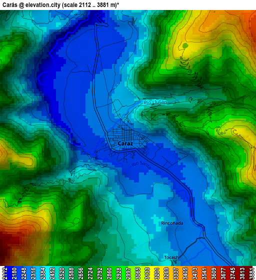
Below is the Elevation map of Carás, which displays elevation range with different colors. Scale of the first map is from 2112 to 3881 m (6929 to 12733 ft) with average elevation of 2586.3 meters (=8485 ft) [note 1]
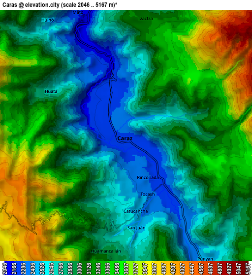
These maps also provides idea of topography and contour of this city, they are displayed at different zoom levels. More info about maps, scale and edge coordinates you can find below images.
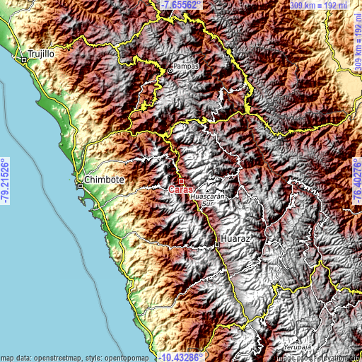
| \ | Map #1 | Map #2 | Topo.Map |
| Scale [m] | 2112..3881 m | 2046..5167 m | × |
| Scale [ft] | 6929..12733 ft | 6713..16952 ft | × |
| Average | 2586.3 m = 8485 ft | 3088.3 m = 10132 ft | × |
| Width | 9.65 km = 6 mi | 19.3 km = 12 mi | 308.8 km = 191.9 mi |
| Height | 9.65 km = 6 mi | 19.3 km = 12 mi | 308.8 km = 191.9 mi |
| ↑Max Latitude | -9.003519° | -8.960112° | -7.65562° |
| Latitude at center | -9.04692° | -9.04692° | -9.04692° |
| ↓Min Latitude | -9.090316° | -9.133707° | -10.43286° |
| ← Min Longitude | -77.852955° | -77.896901° | -79.21526° |
| Longitude center | -77.80901° | -77.80901° | -77.80901° |
| →Max Longitude | -77.765065° | -77.721119° | -76.40276° |
Nearby cities:
Cities around Carás sort by population:
• Yungay elevation 2521 m
12.4 km,  144°
144°
• Carhuac 2738 m
27.1 km,  151°
151°
• Huallanca 1469 m
26.4 km,  346°
346°
• Shupluy 2497 m
22.8 km, 146°
• Cascapara 2727 m
22.3 km, 152°
• Pamparomas 2755 m
19.2 km,  261°
261°
• Mancos 2511 m
19.2 km, 146°
• Ranrahirca 2505 m
16.8 km, 145°
• Matacoto 2530 m
16 km,  155°
155°
• Sucre 2340 m
11.7 km,  337°
337°
• Huaripampa 2197 m
11.1 km, 346°
• Huata 2684 m
6.6 km,  301°
301°
Multilingual:
 En español:
Carás elevación 2275 m.
 En France:
Carás élévation 2275 m.


Sources and notes:
- [note 1] Map square and city borders are not equal. Map elevation data is calculated only from area inside that square.
- [src 1] Elevation data from geonames database provided with same terms of usage.
- [src 2] The elevation map of Carás is generated using elevation data from NASA's 3 arcsec (90m) resolution SRTM data.
- [src 3] Base (background) map © OpenStreetMap contributors tiles are generated by Geofabrik and OpenTopoMap.
Copyright & License:
This Carás Elevation Map is licensed under CC BY-SA. You may reuse any part from this page, if you give a proper credit by linking to this URL:
 More info on terms of use page.