Huallanca elevation
Huallanca (Ancash, Provincia de Huaylas), Peru elevation is 1469 meters and Huallanca elevation in feet is 4820 ft above sea level [src 1]. Huallanca is a seat of a third-order administrative division (feature code) with elevation that is 852 meters (2795 ft) smaller than average city elevation in Peru.
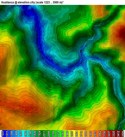
Below is the Elevation map of Huallanca, which displays elevation range with different colors. Scale of the first map is from 1223 to 3500 m (4012 to 11483 ft) with average elevation of 2184.2 meters (=7166 ft) [note 1]
These maps also provides idea of topography and contour of this city, they are displayed at different zoom levels. More info about maps, scale and edge coordinates you can find below images.
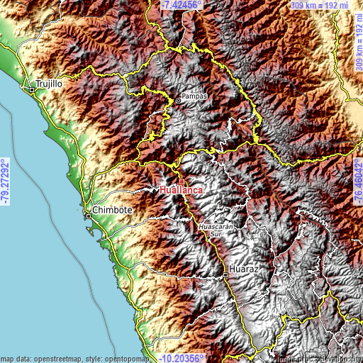
| \ | Map #1 | Topo.Map |
| Scale [m] | 1223..3500 m | × |
| Scale [ft] | 4012..11483 ft | × |
| Average | 2184.2 m = 7166 ft | × |
| Width | 9.66 km = 6 mi | 309 km = 192 mi |
| Height | 9.66 km = 6 mi | 309 km = 192 mi |
| ↑Max Latitude | -8.773241° | -7.42456° |
| Latitude at center | -8.81667° | -8.81667° |
| ↓Min Latitude | -8.860093° | -10.20356° |
| ← Min Longitude | -77.910615° | -79.27292° |
| Longitude center | -77.86667° | -77.86667° |
| →Max Longitude | -77.822725° | -76.46042° |
Nearby cities:
Cities around Huallanca sort by population:
• Carás elevation 2275 m
26.4 km,  166°
166°
• Yungay 2521 m
38.2 km,  159°
159°
• Aco 3304 m
31.6 km,  356°
356°
• Pamparomas 2755 m
31.2 km,  203°
203°
• Bambas 2748 m
28.2 km,  328°
328°
• Corongo 2594 m
26.5 km,  348°
348°
• Macate 2127 m
24.4 km,  283°
283°
• Huata 2684 m
22.2 km,  178°
178°
• Yanac 2791 m
22.2 km,  0°
0°
• La Pampa 1666 m
18.9 km, 348°
• Huaripampa 2197 m
15.3 km, 166°
• Sucre 2340 m
14.9 km, 172°
Multilingual:
 En español:
Huallanca elevación 1469 m.
 En France:
Huallanca élévation 1469 m.
 Auf Deutsch:
Huallanca höhe über dem Meeresspiegel ist 1469 m.

Sources and notes:
- [note 1] Map square and city borders are not equal. Map elevation data is calculated only from area inside that square.
- [src 1] Elevation data from geonames database provided with same terms of usage.
- [src 2] The elevation map of Huallanca is generated using elevation data from NASA's 3 arcsec (90m) resolution SRTM data.
- [src 3] Base (background) map © OpenStreetMap contributors tiles are generated by Geofabrik and OpenTopoMap.
Copyright & License:
This Huallanca Elevation Map is licensed under CC BY-SA. You may reuse any part from this page, if you give a proper credit by linking to this URL:
 More info on terms of use page.