Pamparomas elevation
Pamparomas (Ancash, Provincia de Huaylas), Peru elevation is 2755 meters and Pamparomas elevation in feet is 9039 ft above sea level [src 1]. Pamparomas is a seat of a third-order administrative division (feature code) with elevation that is 434 meters (1424 ft) bigger than average city elevation in Peru.
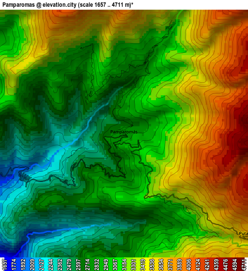
Below is the Elevation map of Pamparomas, which displays elevation range with different colors. Scale of the first map is from 1657 to 4711 m (5436 to 15456 ft) with average elevation of 3091.8 meters (=10144 ft) [note 1]
These maps also provides idea of topography and contour of this city, they are displayed at different zoom levels. More info about maps, scale and edge coordinates you can find below images.
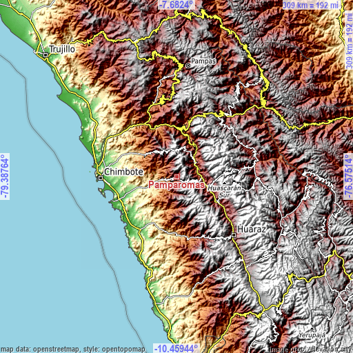
| \ | Map #1 | Topo.Map |
| Scale [m] | 1657..4711 m | × |
| Scale [ft] | 5436..15456 ft | × |
| Average | 3091.8 m = 10144 ft | × |
| Width | 9.65 km = 6 mi | 308.8 km = 191.9 mi |
| Height | 9.65 km = 6 mi | 308.8 km = 191.9 mi |
| ↑Max Latitude | -9.030212° | -7.6824° |
| Latitude at center | -9.07361° | -9.07361° |
| ↓Min Latitude | -9.117003° | -10.45944° |
| ← Min Longitude | -78.025335° | -79.38764° |
| Longitude center | -77.98139° | -77.98139° |
| →Max Longitude | -77.937445° | -76.57514° |
Nearby cities:
Cities around Pamparomas sort by population:
• Carás elevation 2275 m
19.2 km,  81°
81°
• Yungay 2521 m
27.1 km,  105°
105°
• Cascapara 2727 m
33.7 km,  120°
120°
• Mancos 2511 m
32.2 km, 113°
• Huallanca 1469 m
31.2 km,  23°
23°
• Ranrahirca 2505 m
30.5 km, 110°
• Quillo 1259 m
29.2 km,  193°
193°
• Matacoto 2530 m
28 km, 114°
• Moro 493 m
23.2 km,  251°
251°
• Huaripampa 2197 m
21.3 km,  49°
49°
• Sucre 2340 m
19.9 km, 46°
• Huata 2684 m
14.7 km,  64°
64°
Multilingual:
 En español:
Pamparomas elevación 2755 m.
 En France:
Pamparomas élévation 2755 m.
 Auf Deutsch:
Pamparomas höhe über dem Meeresspiegel ist 2755 m.

Sources and notes:
- [note 1] Map square and city borders are not equal. Map elevation data is calculated only from area inside that square.
- [src 1] Elevation data from geonames database provided with same terms of usage.
- [src 2] The elevation map of Pamparomas is generated using elevation data from NASA's 3 arcsec (90m) resolution SRTM data.
- [src 3] Base (background) map © OpenStreetMap contributors tiles are generated by Geofabrik and OpenTopoMap.
Copyright & License:
This Pamparomas Elevation Map is licensed under CC BY-SA. You may reuse any part from this page, if you give a proper credit by linking to this URL:
 More info on terms of use page.