Chepén elevation
Chepén (La Libertad, Chepen), Peru elevation is 239 meters and Chepén elevation in feet is 784 ft above sea level [src 1]. Chepén is a populated place (feature code) with elevation that is 2082 meters (6831 ft) smaller than average city elevation in Peru.
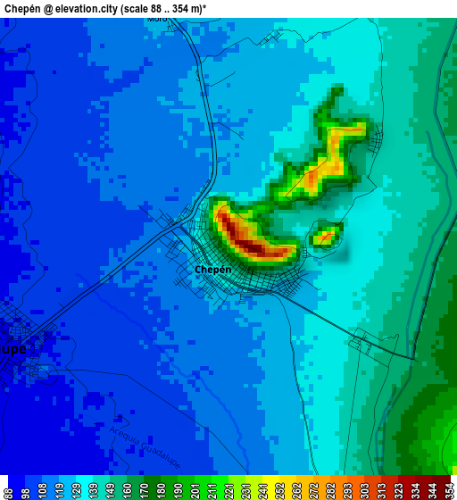
Below is the Elevation map of Chepén, which displays elevation range with different colors. Scale of the first map is from 88 to 354 m (289 to 1161 ft) with average elevation of 128.2 meters (=421 ft) [note 1]
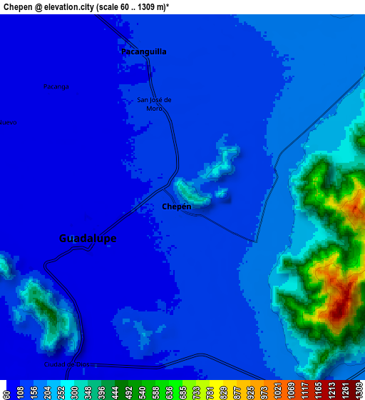
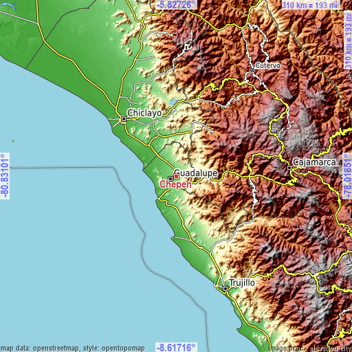
These maps also provides idea of topography and contour of this city, they are displayed at different zoom levels. More info about maps, scale and edge coordinates you can find below images.
| \ | Map #1 | Map #2 | Topo.Map |
| Scale [m] | 88..354 m | 60..1309 m | × |
| Scale [ft] | 289..1161 ft | 197..4295 ft | × |
| Average | 128.2 m = 421 ft | 179.8 m = 590 ft | × |
| Width | 9.69 km = 6 mi | 19.39 km = 12 mi | 310.2 km = 192.7 mi |
| Height | 9.69 km = 6 mi | 19.39 km = 12 mi | 310.2 km = 192.7 mi |
| ↑Max Latitude | -7.180761° | -7.137159° | -5.82726° |
| Latitude at center | -7.22436° | -7.22436° | -7.22436° |
| ↓Min Latitude | -7.267954° | -7.311544° | -8.61716° |
| ← Min Longitude | -79.468705° | -79.512651° | -80.83101° |
| Longitude center | -79.42476° | -79.42476° | -79.42476° |
| →Max Longitude | -79.380815° | -79.336869° | -78.01851° |
Nearby cities:
Cities around Chepén sort by population:
• Saña elevation 65 m
38.1 km,  332°
332°
• Pacasmayo 12 m
25.4 km,  219°
219°
• Guadalupe 83 m
7.1 km,  246°
246°
• San Pedro de Lloc 48 m
24.4 km,  201°
201°
• Pacanga 82 m
10.5 km,  307°
307°
• Oyotún 207 m
44.4 km,  17°
17°
• Pueblo Nuevo 75 m
10.8 km,  292°
292°
• San Gregorio 1574 m
40.7 km,  61°
61°
• Nueva Arica 174 m
40.1 km,  13°
13°
• Nanchoc 395 m
35.7 km,  34°
34°
• Mocupe 34 m
33.8 km,  320°
320°
• Tembladera 642 m
30.7 km,  98°
98°
Multilingual:
 En español:
Chepén elevación 239 m.
 En France:
Chepén élévation 239 m.


Sources and notes:
- [note 1] Map square and city borders are not equal. Map elevation data is calculated only from area inside that square.
- [src 1] Elevation data from geonames database provided with same terms of usage.
- [src 2] The elevation map of Chepén is generated using elevation data from NASA's 3 arcsec (90m) resolution SRTM data.
- [src 3] Base (background) map © OpenStreetMap contributors tiles are generated by Geofabrik and OpenTopoMap.
Copyright & License:
This Chepén Elevation Map is licensed under CC BY-SA. You may reuse any part from this page, if you give a proper credit by linking to this URL:
 More info on terms of use page.