Mocupe elevation
Mocupe (Lambayeque, Provincia de Chiclayo), Peru elevation is 34 meters and Mocupe elevation in feet is 112 ft above sea level [src 1]. Mocupe is a seat of a third-order administrative division (feature code) with elevation that is 2287 meters (7503 ft) smaller than average city elevation in Peru.
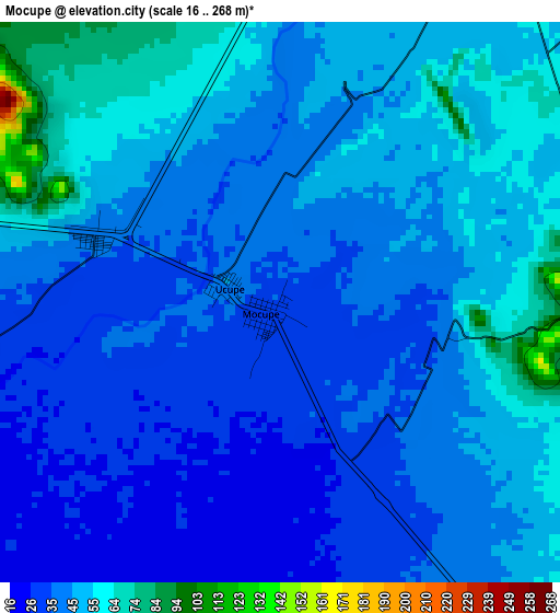
Below is the Elevation map of Mocupe, which displays elevation range with different colors. Scale of the first map is from 16 to 268 m (52 to 879 ft) with average elevation of 43.8 meters (=144 ft) [note 1]
These maps also provides idea of topography and contour of this city, they are displayed at different zoom levels. More info about maps, scale and edge coordinates you can find below images.
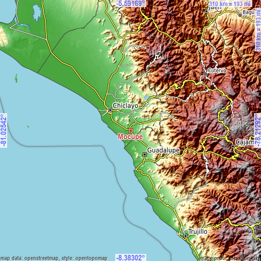
| \ | Map #1 | Topo.Map |
| Scale [m] | 16..268 m | × |
| Scale [ft] | 52..879 ft | × |
| Average | 43.8 m = 144 ft | × |
| Width | 9.7 km = 6 mi | 310.4 km = 192.9 mi |
| Height | 9.7 km = 6 mi | 310.4 km = 192.9 mi |
| ↑Max Latitude | -6.945819° | -5.59169° |
| Latitude at center | -6.98944° | -6.98944° |
| ↓Min Latitude | -7.033057° | -8.38302° |
| ← Min Longitude | -79.663115° | -81.02542° |
| Longitude center | -79.61917° | -79.61917° |
| →Max Longitude | -79.575225° | -78.21292° |
Nearby cities:
Cities around Mocupe sort by population:
• Chiclayo elevation 35 m
34.5 km,  314°
314°
• Chepén 239 m
33.8 km,  140°
140°
• Saña 65 m
8.9 km,  27°
27°
• Monsefú 14 m
30.4 km,  294°
294°
• Guadalupe 83 m
32.6 km,  152°
152°
• Eten 8 m
28.5 km, 288°
• Santa Rosa 33 m
34.5 km,  318°
318°
• Reque 25 m
25.9 km,  302°
302°
• Pacanga 82 m
23.7 km, 146°
• Pueblo Nuevo 75 m
24.9 km, 152°
• Nueva Arica 174 m
33.2 km,  66°
66°
• Pomalca 46 m
30.2 km, 324°
Multilingual:
 En español:
Mocupe elevación 34 m.
 En France:
Mocupe élévation 34 m.


Sources and notes:
- [note 1] Map square and city borders are not equal. Map elevation data is calculated only from area inside that square.
- [src 1] Elevation data from geonames database provided with same terms of usage.
- [src 2] The elevation map of Mocupe is generated using elevation data from NASA's 3 arcsec (90m) resolution SRTM data.
- [src 3] Base (background) map © OpenStreetMap contributors tiles are generated by Geofabrik and OpenTopoMap.
Copyright & License:
This Mocupe Elevation Map is licensed under CC BY-SA. You may reuse any part from this page, if you give a proper credit by linking to this URL:
 More info on terms of use page.