Eten elevation
Eten (Lambayeque, Provincia de Chiclayo), Peru elevation is 8 meters and Eten elevation in feet is 26 ft above sea level [src 1]. Eten is a seat of a third-order administrative division (feature code) with elevation that is 2313 meters (7589 ft) smaller than average city elevation in Peru.
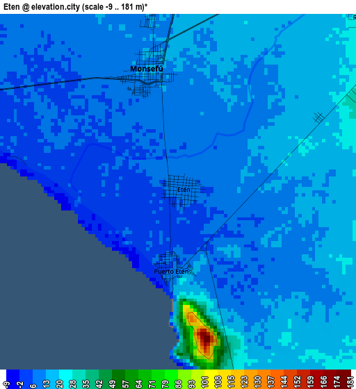
Below is the Elevation map of Eten, which displays elevation range with different colors. Scale of the first map is from -9 to 181 m (-30 to 594 ft) with average elevation of 12.3 meters (=40 ft) [note 1]
These maps also provides idea of topography and contour of this city, they are displayed at different zoom levels. More info about maps, scale and edge coordinates you can find below images.
| \ | Map #1 | Map #2 | Topo.Map |
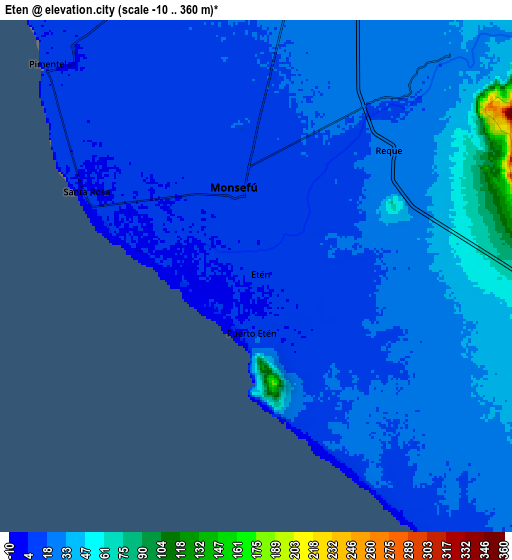
| Scale [m] | -9..181 m | -10..360 m | × |
| Scale [ft] | -30..594 ft | -33..1181 ft | × |
| Average | 12.3 m = 40 ft | 22.9 m = 75 ft | × |
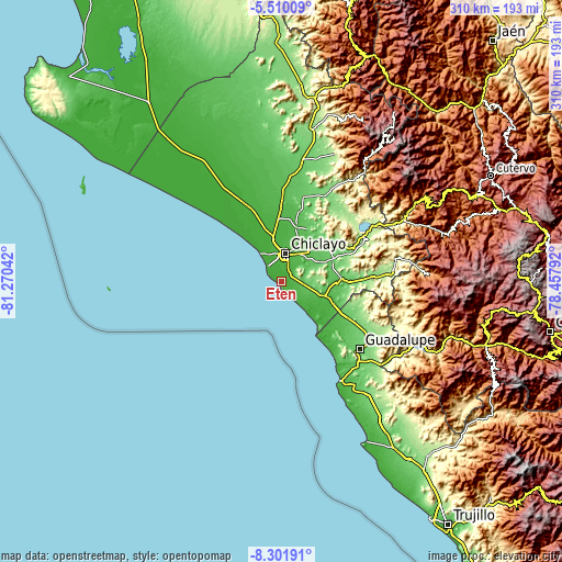
| Width | 9.7 km = 6 mi | 19.4 km = 12.1 mi | 310.4 km = 192.9 mi |
| Height | 9.7 km = 6 mi | 19.4 km = 12.1 mi | 310.5 km = 192.9 mi |
| ↑Max Latitude | -6.864432° | -6.820799° | -5.51009° |
| Latitude at center | -6.90806° | -6.90806° | -6.90806° |
| ↓Min Latitude | -6.951684° | -6.995304° | -8.30191° |
| ← Min Longitude | -79.908115° | -79.952061° | -81.27042° |
| Longitude center | -79.86417° | -79.86417° | -79.86417° |
| →Max Longitude | -79.820225° | -79.776279° | -78.45792° |
Nearby cities:
Cities around Eten sort by population:
• Chiclayo elevation 35 m
15.4 km,  9°
9°
• Lambayeque 23 m
23.5 km,  348°
348°
• Picsi 41 m
23.6 km,  26°
26°
• Ferreñafe 42 m
31.1 km,  15°
15°
• Monsefú 14 m
3.8 km, 352°
• Pimentel 7 m
11.1 km,  315°
315°
• Santa Rosa 33 m
17.2 km, 13°
• Reque 25 m
7 km,  47°
47°
• San José 31 m
19.3 km, 12°
• Mocupe 34 m
28.5 km,  108°
108°
• Pomalca 46 m
18.3 km, 31°
• Santa Rosa 5 m
6.8 km,  296°
296°
Multilingual:
 En español:
Eten elevación 8 m.
 En France:
Eten élévation 8 m.


Sources and notes:
- [note 1] Map square and city borders are not equal. Map elevation data is calculated only from area inside that square.
- [src 1] Elevation data from geonames database provided with same terms of usage.
- [src 2] The elevation map of Eten is generated using elevation data from NASA's 3 arcsec (90m) resolution SRTM data.
- [src 3] Base (background) map © OpenStreetMap contributors tiles are generated by Geofabrik and OpenTopoMap.
Copyright & License:
This Eten Elevation Map is licensed under CC BY-SA. You may reuse any part from this page, if you give a proper credit by linking to this URL:
 More info on terms of use page.