Ferreñafe elevation
Ferreñafe (Lambayeque, Provincia de Ferreñafe), Peru elevation is 42 meters and Ferreñafe elevation in feet is 138 ft above sea level [src 1]. Ferreñafe is a seat of a third-order administrative division (feature code) with elevation that is 2279 meters (7477 ft) smaller than average city elevation in Peru.
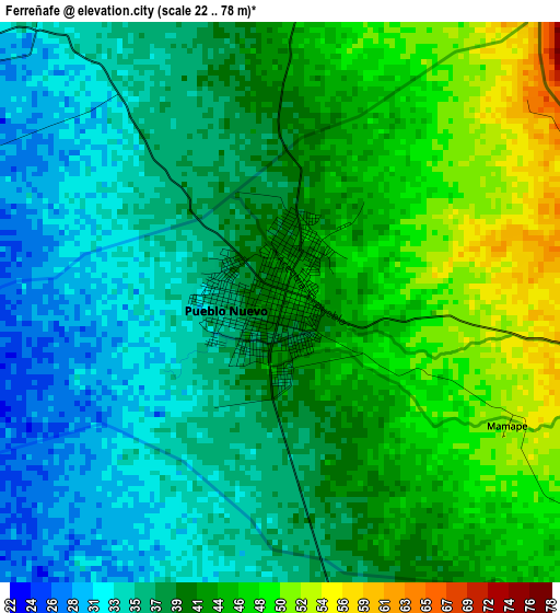
Below is the Elevation map of Ferreñafe, which displays elevation range with different colors. Scale of the first map is from 22 to 78 m (72 to 256 ft) with average elevation of 40.1 meters (=132 ft) [note 1]
These maps also provides idea of topography and contour of this city, they are displayed at different zoom levels. More info about maps, scale and edge coordinates you can find below images.
| \ | Map #1 | Map #2 | Topo.Map |
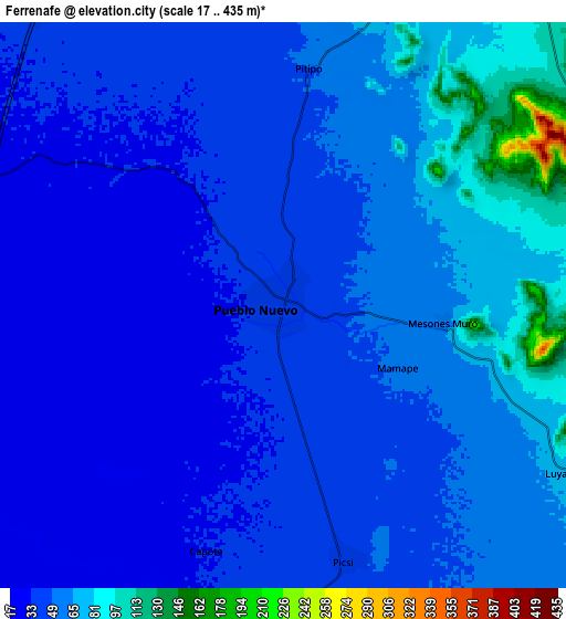
| Scale [m] | 22..78 m | 17..435 m | × |
| Scale [ft] | 72..256 ft | 56..1427 ft | × |
| Average | 40.1 m = 132 ft | 50.4 m = 165 ft | × |
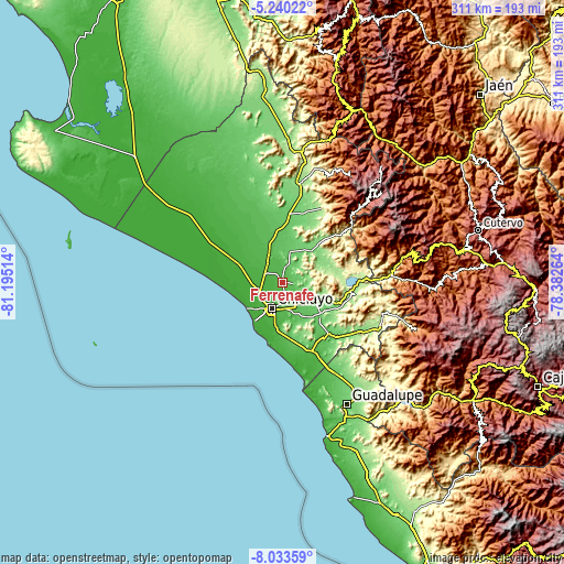
| Width | 9.71 km = 6 mi | 19.41 km = 12.1 mi | 310.6 km = 193 mi |
| Height | 9.71 km = 6 mi | 19.41 km = 12.1 mi | 310.6 km = 193 mi |
| ↑Max Latitude | -6.595237° | -6.551581° | -5.24022° |
| Latitude at center | -6.63889° | -6.63889° | -6.63889° |
| ↓Min Latitude | -6.682539° | -6.726184° | -8.03359° |
| ← Min Longitude | -79.832835° | -79.876781° | -81.19514° |
| Longitude center | -79.78889° | -79.78889° | -79.78889° |
| →Max Longitude | -79.744945° | -79.700999° | -78.38264° |
Nearby cities:
Cities around Ferreñafe sort by population:
• Chiclayo elevation 35 m
15.8 km,  201°
201°
• Lambayeque 23 m
14.7 km,  241°
241°
• Picsi 41 m
9 km,  166°
166°
• Santa Rosa 33 m
13.9 km, 197°
• Reque 25 m
25.4 km,  187°
187°
• Mochumí 40 m
13.3 km,  322°
322°
• San José 31 m
11.8 km, 201°
• Túcume 46 m
16.6 km,  332°
332°
• Mórrope 19 m
27.1 km,  295°
295°
• Pacora 56 m
24 km,  346°
346°
• Pomalca 46 m
14.4 km, 174°
• Manuel Antonio Mesones Muro 63 m
5.6 km,  95°
95°
Multilingual:
 En español:
Ferreñafe elevación 42 m.
 En France:
Ferreñafe élévation 42 m.
 Auf Deutsch:
Ferreñafe höhe über dem Meeresspiegel ist 42 m.

Sources and notes:
- [note 1] Map square and city borders are not equal. Map elevation data is calculated only from area inside that square.
- [src 1] Elevation data from geonames database provided with same terms of usage.
- [src 2] The elevation map of Ferreñafe is generated using elevation data from NASA's 3 arcsec (90m) resolution SRTM data.
- [src 3] Base (background) map © OpenStreetMap contributors tiles are generated by Geofabrik and OpenTopoMap.
Copyright & License:
This Ferreñafe Elevation Map is licensed under CC BY-SA. You may reuse any part from this page, if you give a proper credit by linking to this URL:
 More info on terms of use page.