Huaraz elevation
Huaraz (Ancash, Provincia de Huaraz), Peru elevation is 3059 meters and Huaraz elevation in feet is 10036 ft above sea level [src 1]. Huaraz is a seat of a first-order administrative division (feature code) with elevation that is 738 meters (2421 ft) bigger than average city elevation in Peru.
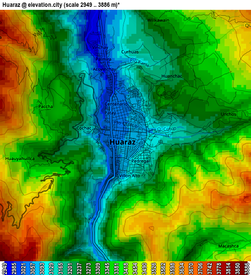
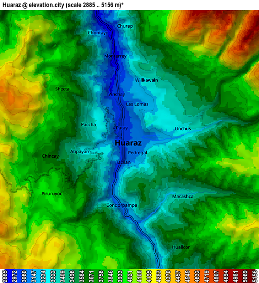
Below is the Elevation map of Huaraz, which displays elevation range with different colors. Scale of the first map is from 2949 to 3886 m (9675 to 12749 ft) with average elevation of 3338.5 meters (=10953 ft) [note 1]
These maps also provides idea of topography and contour of this city, they are displayed at different zoom levels. More info about maps, scale and edge coordinates you can find below images.
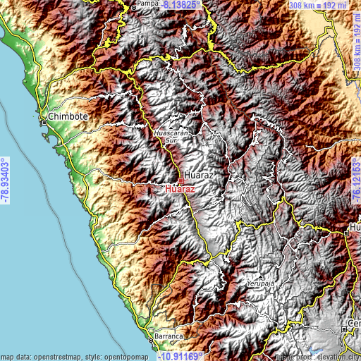
| \ | Map #1 | Map #2 | Topo.Map |
| Scale [m] | 2949..3886 m | 2885..5156 m | × |
| Scale [ft] | 9675..12749 ft | 9465..16916 ft | × |
| Average | 3338.5 m = 10953 ft | 3733.7 m = 12250 ft | × |
| Width | 9.64 km = 6 mi | 19.28 km = 12 mi | 308.4 km = 191.6 mi |
| Height | 9.64 km = 6 mi | 19.28 km = 12 mi | 308.4 km = 191.6 mi |
| ↑Max Latitude | -9.484448° | -9.441101° | -8.13825° |
| Latitude at center | -9.52779° | -9.52779° | -9.52779° |
| ↓Min Latitude | -9.571126° | -9.614457° | -10.91169° |
| ← Min Longitude | -77.571725° | -77.615671° | -78.93403° |
| Longitude center | -77.52778° | -77.52778° | -77.52778° |
| →Max Longitude | -77.483835° | -77.439889° | -76.12153° |
Nearby cities:
Cities around Huaraz sort by population:
• Cajamarquilla elevation 3242 m
27 km,  244°
244°
• Ticapampa 3498 m
26.1 km,  160°
160°
• La Merced 3289 m
25 km,  202°
202°
• Marcara District 2741 m
24.3 km,  339°
339°
• Recuay 3406 m
23 km, 160°
• Pira 3007 m
21.2 km,  258°
258°
• Anta 2781 m
20.3 km, 337°
• Yungar 2832 m
18.2 km, 336°
• Aco 2990 m
18.1 km,  347°
347°
• Tarica 2822 m
15.8 km, 340°
• Jangas 2817 m
14.9 km, 339°
• Olleros 3522 m
12.7 km, 157°
Multilingual:
 En español:
Huaraz elevación 3059 m.
 En France:
Huaraz élévation 3059 m.


Sources and notes:
- [note 1] Map square and city borders are not equal. Map elevation data is calculated only from area inside that square.
- [src 1] Elevation data from geonames database provided with same terms of usage.
- [src 2] The elevation map of Huaraz is generated using elevation data from NASA's 3 arcsec (90m) resolution SRTM data.
- [src 3] Base (background) map © OpenStreetMap contributors tiles are generated by Geofabrik and OpenTopoMap.
Copyright & License:
This Huaraz Elevation Map is licensed under CC BY-SA. You may reuse any part from this page, if you give a proper credit by linking to this URL:
 More info on terms of use page.