Yungar elevation
Yungar (Ancash, Provincia de Carhuaz), Peru elevation is 2832 meters and Yungar elevation in feet is 9291 ft above sea level [src 1]. Yungar is a seat of a third-order administrative division (feature code) with elevation that is 511 meters (1677 ft) bigger than average city elevation in Peru.
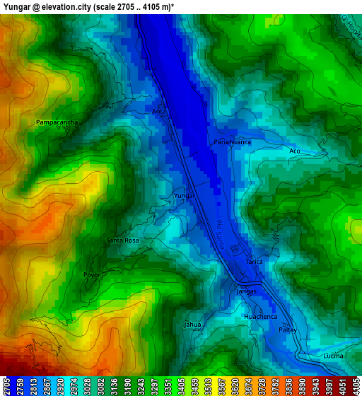
Below is the Elevation map of Yungar, which displays elevation range with different colors. Scale of the first map is from 2705 to 4105 m (8875 to 13468 ft) with average elevation of 3180.7 meters (=10435 ft) [note 1]
These maps also provides idea of topography and contour of this city, they are displayed at different zoom levels. More info about maps, scale and edge coordinates you can find below images.
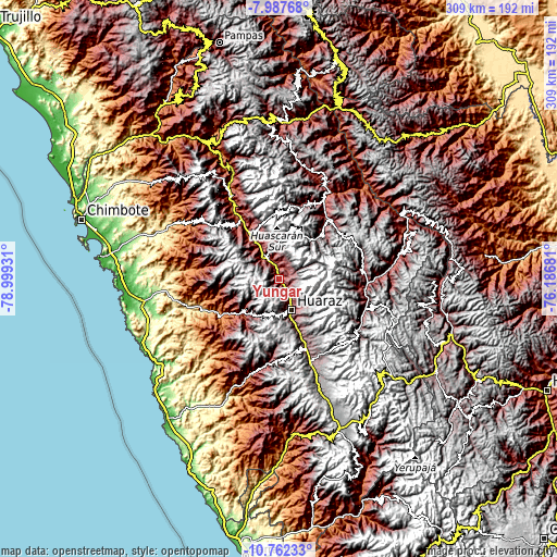
| \ | Map #1 | Topo.Map |
| Scale [m] | 2705..4105 m | × |
| Scale [ft] | 8875..13468 ft | × |
| Average | 3180.7 m = 10435 ft | × |
| Width | 9.64 km = 6 mi | 308.5 km = 191.7 mi |
| Height | 9.64 km = 6 mi | 308.5 km = 191.7 mi |
| ↑Max Latitude | -9.334419° | -7.98768° |
| Latitude at center | -9.37778° | -9.37778° |
| ↓Min Latitude | -9.421135° | -10.76233° |
| ← Min Longitude | -77.637005° | -78.99931° |
| Longitude center | -77.59306° | -77.59306° |
| →Max Longitude | -77.549115° | -76.18681° |
Nearby cities:
Cities around Yungar sort by population:
• Huaraz elevation 3059 m
18.2 km,  156°
156°
• Carhuaz 2650 m
12.1 km,  331°
331°
• Carhuac 2738 m
16.9 km,  319°
319°
• Shilla 3026 m
16.7 km,  347°
347°
• Amashca 2873 m
16.5 km,  339°
339°
• Tinco 2588 m
15.3 km, 321°
• Acopampa 2743 m
9.4 km, 343°
• Marcara District 2741 m
6.3 km, 349°
• Aco 2990 m
3.4 km,  73°
73°
• Jangas 2817 m
3.3 km,  145°
145°
• Tarica 2822 m
2.7 km,  131°
131°
• Anta 2781 m
2.2 km, 347°
Multilingual:
 En español:
Yungar elevación 2832 m.
 En France:
Yungar élévation 2832 m.


Sources and notes:
- [note 1] Map square and city borders are not equal. Map elevation data is calculated only from area inside that square.
- [src 1] Elevation data from geonames database provided with same terms of usage.
- [src 2] The elevation map of Yungar is generated using elevation data from NASA's 3 arcsec (90m) resolution SRTM data.
- [src 3] Base (background) map © OpenStreetMap contributors tiles are generated by Geofabrik and OpenTopoMap.
Copyright & License:
This Yungar Elevation Map is licensed under CC BY-SA. You may reuse any part from this page, if you give a proper credit by linking to this URL:
 More info on terms of use page.