Olleros elevation
Olleros (Ancash, Provincia de Huaraz), Peru elevation is 3522 meters and Olleros elevation in feet is 11555 ft above sea level [src 1]. Olleros is a seat of a third-order administrative division (feature code) with elevation that is 1201 meters (3940 ft) bigger than average city elevation in Peru.
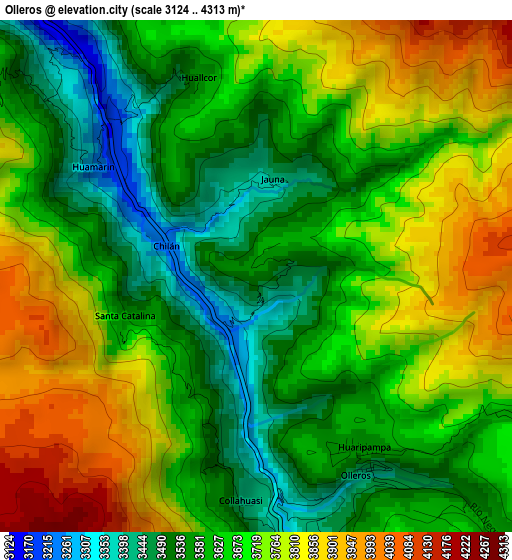
Below is the Elevation map of Olleros, which displays elevation range with different colors. Scale of the first map is from 3124 to 4313 m (10249 to 14150 ft) with average elevation of 3671.3 meters (=12045 ft) [note 1]
These maps also provides idea of topography and contour of this city, they are displayed at different zoom levels. More info about maps, scale and edge coordinates you can find below images.
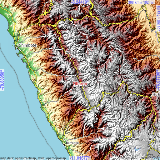
| \ | Map #1 | Topo.Map |
| Scale [m] | 3124..4313 m | × |
| Scale [ft] | 10249..14150 ft | × |
| Average | 3671.3 m = 12045 ft | × |
| Width | 9.63 km = 6 mi | 308.3 km = 191.6 mi |
| Height | 9.63 km = 6 mi | 308.3 km = 191.6 mi |
| ↑Max Latitude | -9.590002° | -8.24419° |
| Latitude at center | -9.63333° | -9.63333° |
| ↓Min Latitude | -9.676653° | -11.01677° |
| ← Min Longitude | -77.527275° | -78.88958° |
| Longitude center | -77.48333° | -77.48333° |
| →Max Longitude | -77.439385° | -76.07708° |
Nearby cities:
Cities around Olleros sort by population:
• Huaraz elevation 3059 m
12.7 km,  337°
337°
• Aco 2990 m
30.7 km, 343°
• Cajamarquilla 3242 m
29.2 km,  270°
270°
• Succha 3554 m
28.8 km,  219°
219°
• Tarica 2822 m
28.5 km, 339°
• Jangas 2817 m
27.6 km, 338°
• Pira 3007 m
26.6 km,  286°
286°
• Aija 3409 m
21.5 km, 220°
• Catac 3541 m
19.3 km,  163°
163°
• La Merced 3289 m
18.5 km,  232°
232°
• Ticapampa 3498 m
13.5 km, 164°
• Recuay 3406 m
10.3 km, 163°
Multilingual:
 En español:
Olleros elevación 3522 m.
 En France:
Olleros élévation 3522 m.
 Auf Deutsch:
Olleros höhe über dem Meeresspiegel ist 3522 m.

Sources and notes:
- [note 1] Map square and city borders are not equal. Map elevation data is calculated only from area inside that square.
- [src 1] Elevation data from geonames database provided with same terms of usage.
- [src 2] The elevation map of Olleros is generated using elevation data from NASA's 3 arcsec (90m) resolution SRTM data.
- [src 3] Base (background) map © OpenStreetMap contributors tiles are generated by Geofabrik and OpenTopoMap.
Copyright & License:
This Olleros Elevation Map is licensed under CC BY-SA. You may reuse any part from this page, if you give a proper credit by linking to this URL:
 More info on terms of use page.