Jamalca elevation
Jamalca (Amazonas, Utcubamba), Peru elevation is 1022 meters and Jamalca elevation in feet is 3353 ft above sea level [src 1]. Jamalca is a seat of a third-order administrative division (feature code) with elevation that is 1299 meters (4262 ft) smaller than average city elevation in Peru.
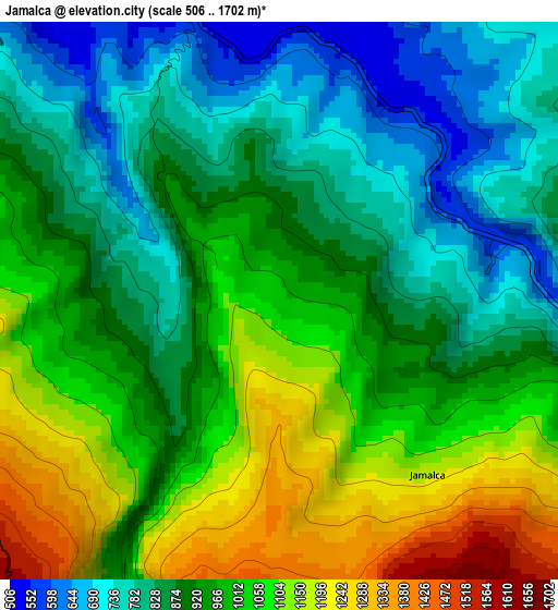
Below is the Elevation map of Jamalca, which displays elevation range with different colors. Scale of the first map is from 506 to 1702 m (1660 to 5584 ft) with average elevation of 949 meters (=3114 ft) [note 1]
These maps also provides idea of topography and contour of this city, they are displayed at different zoom levels. More info about maps, scale and edge coordinates you can find below images.
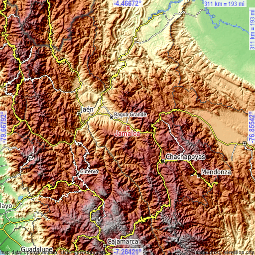
| \ | Map #1 | Topo.Map |
| Scale [m] | 506..1702 m | × |
| Scale [ft] | 1660..5584 ft | × |
| Average | 949 m = 3114 ft | × |
| Width | 9.72 km = 6 mi | 311.1 km = 193.3 mi |
| Height | 9.72 km = 6 mi | 311.1 km = 193.3 mi |
| ↑Max Latitude | -5.823503° | -4.46672° |
| Latitude at center | -5.86722° | -5.86722° |
| ↓Min Latitude | -5.910933° | -7.26421° |
| ← Min Longitude | -78.305615° | -79.66792° |
| Longitude center | -78.26167° | -78.26167° |
| →Max Longitude | -78.217725° | -76.85542° |
Nearby cities:
Cities around Jamalca sort by population:
• La Peca elevation 897 m
34.3 km,  326°
326°
• Bagua Grande 450 m
23.4 km,  301°
301°
• Cajaruro 465 m
23.2 km,  308°
308°
• Cujillo 1503 m
40.9 km,  227°
227°
• Bagua 430 m
39.8 km, 310°
• Paclas 2443 m
38.3 km,  124°
124°
• San Carlos 2023 m
38 km,  106°
106°
• Churuja 1414 m
37.8 km, 115°
• Cuispes 1914 m
36.7 km,  98°
98°
• El Parco District 596 m
35.9 km,  318°
318°
• Santa Catalina 2564 m
35.1 km,  140°
140°
• Lonya Grande 1209 m
30.9 km,  214°
214°
Multilingual:
 En español:
Jamalca elevación 1022 m.
 En France:
Jamalca élévation 1022 m.
 Auf Deutsch:
Jamalca höhe über dem Meeresspiegel ist 1022 m.

Sources and notes:
- [note 1] Map square and city borders are not equal. Map elevation data is calculated only from area inside that square.
- [src 1] Elevation data from geonames database provided with same terms of usage.
- [src 2] The elevation map of Jamalca is generated using elevation data from NASA's 3 arcsec (90m) resolution SRTM data.
- [src 3] Base (background) map © OpenStreetMap contributors tiles are generated by Geofabrik and OpenTopoMap.
Copyright & License:
This Jamalca Elevation Map is licensed under CC BY-SA. You may reuse any part from this page, if you give a proper credit by linking to this URL:
 More info on terms of use page.