Cuispes elevation
Cuispes (Amazonas, Provincia de Bongará), Peru elevation is 1914 meters and Cuispes elevation in feet is 6280 ft above sea level [src 1]. Cuispes is a seat of a third-order administrative division (feature code) with elevation that is 407 meters (1335 ft) smaller than average city elevation in Peru.
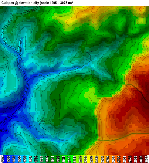
Below is the Elevation map of Cuispes, which displays elevation range with different colors. Scale of the first map is from 1295 to 3075 m (4249 to 10089 ft) with average elevation of 1986.8 meters (=6518 ft) [note 1]
These maps also provides idea of topography and contour of this city, they are displayed at different zoom levels. More info about maps, scale and edge coordinates you can find below images.
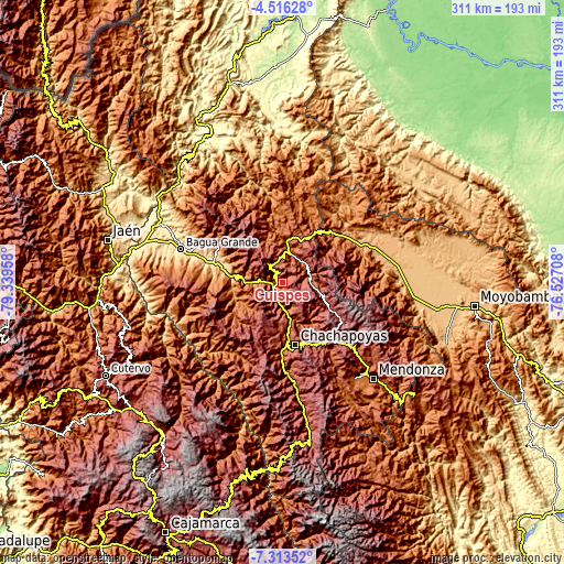
| \ | Map #1 | Topo.Map |
| Scale [m] | 1295..3075 m | × |
| Scale [ft] | 4249..10089 ft | × |
| Average | 1986.8 m = 6518 ft | × |
| Width | 9.72 km = 6 mi | 311 km = 193.2 mi |
| Height | 9.72 km = 6 mi | 311.1 km = 193.3 mi |
| ↑Max Latitude | -5.872957° | -4.51628° |
| Latitude at center | -5.91667° | -5.91667° |
| ↓Min Latitude | -5.960379° | -7.31352° |
| ← Min Longitude | -77.977275° | -79.33958° |
| Longitude center | -77.93333° | -77.93333° |
| →Max Longitude | -77.889385° | -76.52708° |
Nearby cities:
Cities around Cuispes sort by population:
• Olleros elevation 3139 m
35 km,  114°
114°
• Quinjalca 3156 m
34.3 km,  124°
124°
• Huancas 2590 m
29.6 km,  165°
165°
• Luya 2311 m
27.5 km,  182°
182°
• Santa Catalina 2564 m
25.9 km,  213°
213°
• Lamud 2327 m
24.6 km,  185°
185°
• Chisquilla 2879 m
22.4 km,  80°
80°
• Olto 2603 m
20.9 km, 187°
• Yambrasbamba 1920 m
18.9 km,  11°
11°
• Paclas 2443 m
16.9 km,  196°
196°
• Churuja 1414 m
11.1 km, 191°
• San Carlos 2023 m
5.6 km, 180°
Multilingual:
 En español:
Cuispes elevación 1914 m.
 En France:
Cuispes élévation 1914 m.
 Auf Deutsch:
Cuispes höhe über dem Meeresspiegel ist 1914 m.

Sources and notes:
- [note 1] Map square and city borders are not equal. Map elevation data is calculated only from area inside that square.
- [src 1] Elevation data from geonames database provided with same terms of usage.
- [src 2] The elevation map of Cuispes is generated using elevation data from NASA's 3 arcsec (90m) resolution SRTM data.
- [src 3] Base (background) map © OpenStreetMap contributors tiles are generated by Geofabrik and OpenTopoMap.
Copyright & License:
This Cuispes Elevation Map is licensed under CC BY-SA. You may reuse any part from this page, if you give a proper credit by linking to this URL:
 More info on terms of use page.