Cajaruro elevation
Cajaruro (Amazonas, Utcubamba), Peru elevation is 465 meters and Cajaruro elevation in feet is 1526 ft above sea level [src 1]. Cajaruro is a seat of a third-order administrative division (feature code) with elevation that is 1856 meters (6089 ft) smaller than average city elevation in Peru.
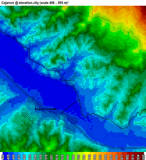
Below is the Elevation map of Cajaruro, which displays elevation range with different colors. Scale of the first map is from 408 to 955 m (1339 to 3133 ft) with average elevation of 528.8 meters (=1735 ft) [note 1]
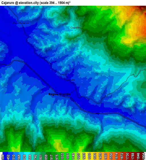
These maps also provides idea of topography and contour of this city, they are displayed at different zoom levels. More info about maps, scale and edge coordinates you can find below images.
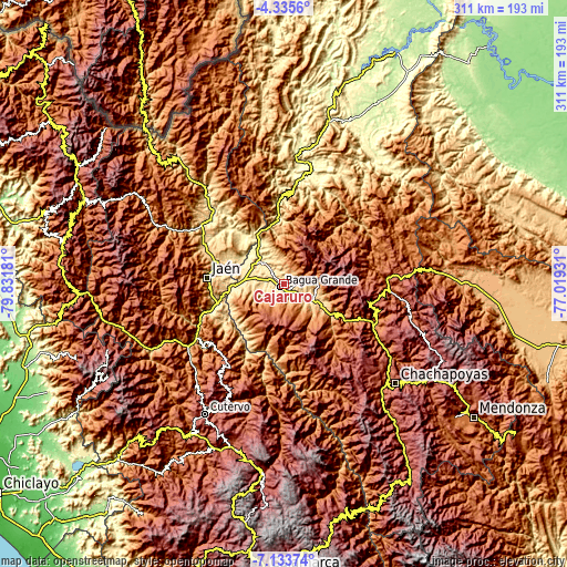
| \ | Map #1 | Map #2 | Topo.Map |
| Scale [m] | 408..955 m | 394..1904 m | × |
| Scale [ft] | 1339..3133 ft | 1293..6247 ft | × |
| Average | 528.8 m = 1735 ft | 693.8 m = 2276 ft | × |
| Width | 9.72 km = 6 mi | 19.45 km = 12.1 mi | 311.1 km = 193.3 mi |
| Height | 9.72 km = 6 mi | 19.45 km = 12.1 mi | 311.2 km = 193.4 mi |
| ↑Max Latitude | -5.692663° | -5.648933° | -4.3356° |
| Latitude at center | -5.73639° | -5.73639° | -5.73639° |
| ↓Min Latitude | -5.780114° | -5.823834° | -7.13374° |
| ← Min Longitude | -78.469505° | -78.513451° | -79.83181° |
| Longitude center | -78.42556° | -78.42556° | -78.42556° |
| →Max Longitude | -78.381615° | -78.337669° | -77.01931° |
Nearby cities:
Cities around Cajaruro sort by population:
• Jaén elevation 730 m
42.4 km,  274°
274°
• La Peca 897 m
14 km,  355°
355°
• Bagua Grande 450 m
2.8 km,  218°
218°
• Bellavista 437 m
29 km,  286°
286°
• La Sacilia 637 m
41.1 km,  234°
234°
• Lonya Grande 1209 m
39.9 km,  179°
179°
• Aramango 536 m
35.6 km, 358°
• Choros 464 m
34.9 km,  238°
238°
• Cumba 462 m
34.2 km, 230°
• Jamalca 1022 m
23.2 km,  128°
128°
• Bagua 430 m
16.6 km,  313°
313°
• El Parco District 596 m
13.6 km,  335°
335°
Multilingual:
 En español:
Cajaruro elevación 465 m.
 En France:
Cajaruro élévation 465 m.
 Auf Deutsch:
Cajaruro höhe über dem Meeresspiegel ist 465 m.

Sources and notes:
- [note 1] Map square and city borders are not equal. Map elevation data is calculated only from area inside that square.
- [src 1] Elevation data from geonames database provided with same terms of usage.
- [src 2] The elevation map of Cajaruro is generated using elevation data from NASA's 3 arcsec (90m) resolution SRTM data.
- [src 3] Base (background) map © OpenStreetMap contributors tiles are generated by Geofabrik and OpenTopoMap.
Copyright & License:
This Cajaruro Elevation Map is licensed under CC BY-SA. You may reuse any part from this page, if you give a proper credit by linking to this URL:
 More info on terms of use page.