Llama elevation
Llama (Ancash, Provincia de Mariscal Luzuriaga), Peru elevation is 3544 meters and Llama elevation in feet is 11627 ft above sea level [src 1]. Llama is a seat of a third-order administrative division (feature code) with elevation that is 1223 meters (4012 ft) bigger than average city elevation in Peru.
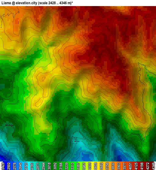
Below is the Elevation map of Llama, which displays elevation range with different colors. Scale of the first map is from 2428 to 4346 m (7966 to 14259 ft) with average elevation of 3545.2 meters (=11631 ft) [note 1]
These maps also provides idea of topography and contour of this city, they are displayed at different zoom levels. More info about maps, scale and edge coordinates you can find below images.
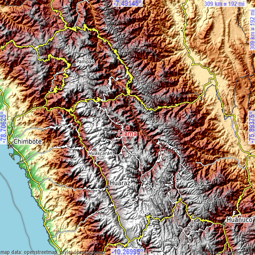
| \ | Map #1 | Topo.Map |
| Scale [m] | 2428..4346 m | × |
| Scale [ft] | 7966..14259 ft | × |
| Average | 3545.2 m = 11631 ft | × |
| Width | 9.66 km = 6 mi | 308.9 km = 191.9 mi |
| Height | 9.66 km = 6 mi | 309 km = 192 mi |
| ↑Max Latitude | -8.839909° | -7.49145° |
| Latitude at center | -8.88333° | -8.88333° |
| ↓Min Latitude | -8.926746° | -10.26995° |
| ← Min Longitude | -77.343945° | -78.70625° |
| Longitude center | -77.3° | -77.3° |
| →Max Longitude | -77.256055° | -75.89375° |
Nearby cities:
Cities around Llama sort by population:
• Yauya elevation 3393 m
11.1 km,  180°
180°
• Pomabamba 3388 m
19.1 km,  286°
286°
• Huancaspata 3306 m
47.4 km,  0°
0°
• Aczo 2668 m
45.3 km,  131°
131°
• Chingas 2852 m
42.9 km, 127°
• Huacaybamba 3165 m
41.8 km,  114°
114°
• Chacas 3900 m
40 km,  193°
193°
• Huacrachuco 3955 m
35.2 km,  42°
42°
• Yanama 3498 m
26.1 km,  230°
230°
• San Luis 3065 m
22.9 km, 193°
• Quinuabamba 4014 m
18.2 km,  336°
336°
• Lucma 3240 m
13.3 km,  253°
253°
Multilingual:
 En español:
Llama elevación 3544 m.
 En France:
Llama élévation 3544 m.


Sources and notes:
- [note 1] Map square and city borders are not equal. Map elevation data is calculated only from area inside that square.
- [src 1] Elevation data from geonames database provided with same terms of usage.
- [src 2] The elevation map of Llama is generated using elevation data from NASA's 3 arcsec (90m) resolution SRTM data.
- [src 3] Base (background) map © OpenStreetMap contributors tiles are generated by Geofabrik and OpenTopoMap.
Copyright & License:
This Llama Elevation Map is licensed under CC BY-SA. You may reuse any part from this page, if you give a proper credit by linking to this URL:
 More info on terms of use page.