Quinuabamba elevation
Quinuabamba (Ancash, Provincia de Pomabamba), Peru elevation is 4014 meters and Quinuabamba elevation in feet is 13169 ft above sea level [src 1]. Quinuabamba is a seat of a third-order administrative division (feature code) with elevation that is 1693 meters (5554 ft) bigger than average city elevation in Peru.
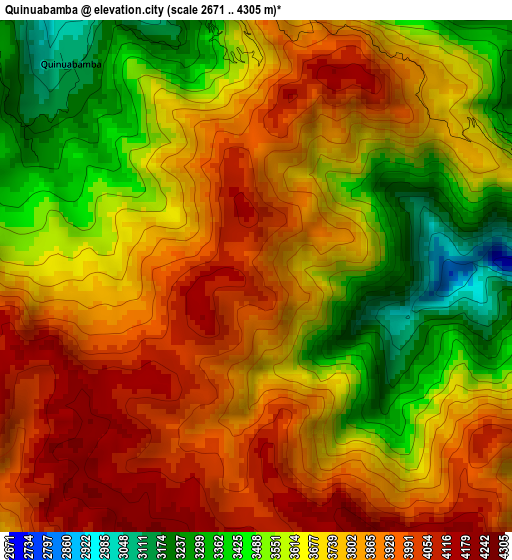
Below is the Elevation map of Quinuabamba, which displays elevation range with different colors. Scale of the first map is from 2671 to 4305 m (8763 to 14124 ft) with average elevation of 3718.6 meters (=12200 ft) [note 1]
These maps also provides idea of topography and contour of this city, they are displayed at different zoom levels. More info about maps, scale and edge coordinates you can find below images.
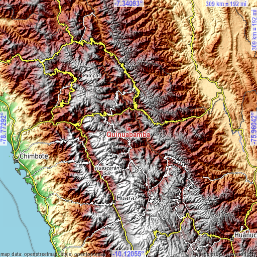
| \ | Map #1 | Topo.Map |
| Scale [m] | 2671..4305 m | × |
| Scale [ft] | 8763..14124 ft | × |
| Average | 3718.6 m = 12200 ft | × |
| Width | 9.66 km = 6 mi | 309.1 km = 192.1 mi |
| Height | 9.66 km = 6 mi | 309.1 km = 192.1 mi |
| ↑Max Latitude | -8.689892° | -7.34093° |
| Latitude at center | -8.73333° | -8.73333° |
| ↓Min Latitude | -8.776763° | -10.12055° |
| ← Min Longitude | -77.410615° | -78.77292° |
| Longitude center | -77.36667° | -77.36667° |
| →Max Longitude | -77.322725° | -75.96042° |
Nearby cities:
Cities around Quinuabamba sort by population:
• Yauya elevation 3393 m
28.7 km,  165°
165°
• Pomabamba 3388 m
15.6 km,  224°
224°
• Quiches 3016 m
40 km,  340°
340°
• San Luis 3065 m
39 km,  177°
177°
• Yanama 3498 m
35.7 km,  201°
201°
• Challas 3296 m
33.2 km,  8°
8°
• Sihuas 2593 m
33.1 km,  303°
303°
• Huacrachuco 3955 m
32.5 km,  73°
73°
• Huancaspata 3306 m
31.7 km, 13°
• Ullulluco 3191 m
31.6 km,  347°
347°
• Lucma 3240 m
21.1 km, 195°
• Llama 3544 m
18.2 km,  156°
156°
Multilingual:
 En español:
Quinuabamba elevación 4014 m.
 En France:
Quinuabamba élévation 4014 m.
 Auf Deutsch:
Quinuabamba höhe über dem Meeresspiegel ist 4014 m.

Sources and notes:
- [note 1] Map square and city borders are not equal. Map elevation data is calculated only from area inside that square.
- [src 1] Elevation data from geonames database provided with same terms of usage.
- [src 2] The elevation map of Quinuabamba is generated using elevation data from NASA's 3 arcsec (90m) resolution SRTM data.
- [src 3] Base (background) map © OpenStreetMap contributors tiles are generated by Geofabrik and OpenTopoMap.
Copyright & License:
This Quinuabamba Elevation Map is licensed under CC BY-SA. You may reuse any part from this page, if you give a proper credit by linking to this URL:
 More info on terms of use page.