Lucma elevation
Lucma (Ancash, Provincia de Mariscal Luzuriaga), Peru elevation is 3240 meters and Lucma elevation in feet is 10630 ft above sea level [src 1]. Lucma is a seat of a third-order administrative division (feature code) with elevation that is 919 meters (3015 ft) bigger than average city elevation in Peru.
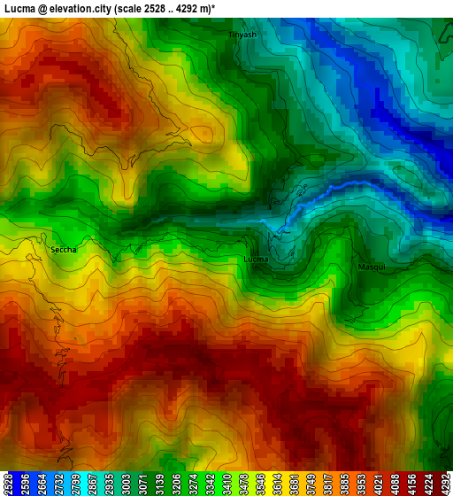
Below is the Elevation map of Lucma, which displays elevation range with different colors. Scale of the first map is from 2528 to 4292 m (8294 to 14081 ft) with average elevation of 3498.1 meters (=11477 ft) [note 1]
These maps also provides idea of topography and contour of this city, they are displayed at different zoom levels. More info about maps, scale and edge coordinates you can find below images.
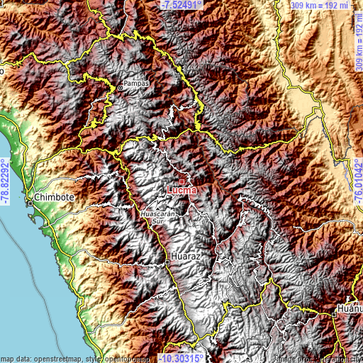
| \ | Map #1 | Topo.Map |
| Scale [m] | 2528..4292 m | × |
| Scale [ft] | 8294..14081 ft | × |
| Average | 3498.1 m = 11477 ft | × |
| Width | 9.65 km = 6 mi | 308.9 km = 191.9 mi |
| Height | 9.65 km = 6 mi | 308.9 km = 191.9 mi |
| ↑Max Latitude | -8.873253° | -7.52491° |
| Latitude at center | -8.91667° | -8.91667° |
| ↓Min Latitude | -8.960082° | -10.30315° |
| ← Min Longitude | -77.460615° | -78.82292° |
| Longitude center | -77.41667° | -77.41667° |
| →Max Longitude | -77.372725° | -76.01042° |
Nearby cities:
Cities around Lucma sort by population:
• Yauya elevation 3393 m
14.8 km,  120°
120°
• Yungay 2521 m
43.5 km,  235°
235°
• Pomabamba 3388 m
10.8 km,  329°
329°
• Mancos 2511 m
44.6 km,  226°
226°
• Ranrahirca 2505 m
43.9 km, 229°
• Amashca 2873 m
43.8 km,  215°
215°
• Shilla 3026 m
41.8 km,  213°
213°
• Chacas 3900 m
35.4 km,  174°
174°
• Quinuabamba 4014 m
21.1 km,  15°
15°
• San Luis 3065 m
19.9 km,  158°
158°
• Yanama 3498 m
14.9 km, 209°
• Llama 3544 m
13.3 km,  73°
73°
Multilingual:
 En español:
Lucma elevación 3240 m.
 En France:
Lucma élévation 3240 m.


Sources and notes:
- [note 1] Map square and city borders are not equal. Map elevation data is calculated only from area inside that square.
- [src 1] Elevation data from geonames database provided with same terms of usage.
- [src 2] The elevation map of Lucma is generated using elevation data from NASA's 3 arcsec (90m) resolution SRTM data.
- [src 3] Base (background) map © OpenStreetMap contributors tiles are generated by Geofabrik and OpenTopoMap.
Copyright & License:
This Lucma Elevation Map is licensed under CC BY-SA. You may reuse any part from this page, if you give a proper credit by linking to this URL:
 More info on terms of use page.