Pomahuaca elevation
Pomahuaca (Cajamarca, Provincia de Jaén), Peru elevation is 1142 meters and Pomahuaca elevation in feet is 3747 ft above sea level [src 1]. Pomahuaca is a seat of a third-order administrative division (feature code) with elevation that is 1179 meters (3868 ft) smaller than average city elevation in Peru.
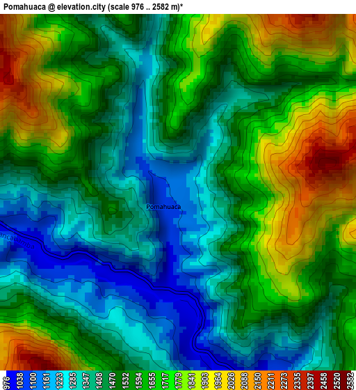
Below is the Elevation map of Pomahuaca, which displays elevation range with different colors. Scale of the first map is from 976 to 2582 m (3202 to 8471 ft) with average elevation of 1544 meters (=5066 ft) [note 1]
These maps also provides idea of topography and contour of this city, they are displayed at different zoom levels. More info about maps, scale and edge coordinates you can find below images.
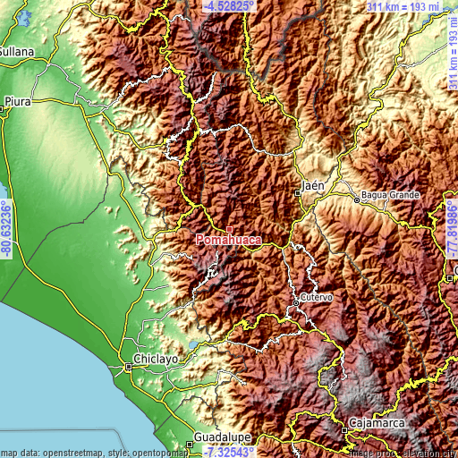
| \ | Map #1 | Topo.Map |
| Scale [m] | 976..2582 m | × |
| Scale [ft] | 3202..8471 ft | × |
| Average | 1544 m = 5066 ft | × |
| Width | 9.72 km = 6 mi | 311 km = 193.2 mi |
| Height | 9.72 km = 6 mi | 311 km = 193.2 mi |
| ↑Max Latitude | -5.884898° | -4.52825° |
| Latitude at center | -5.92861° | -5.92861° |
| ↓Min Latitude | -5.972319° | -7.32543° |
| ← Min Longitude | -79.270055° | -80.63236° |
| Longitude center | -79.22611° | -79.22611° |
| →Max Longitude | -79.182165° | -77.81986° |
Nearby cities:
Cities around Pomahuaca sort by population:
• Jaén elevation 730 m
52.4 km,  61°
61°
• Miracosta 2969 m
53.3 km,  186°
186°
• Las Pirias 1603 m
53.2 km,  50°
50°
• Querocoto 2445 m
52.3 km,  156°
156°
• Huarmaca 2211 m
51.9 km,  320°
320°
• Huabal 1473 m
48.3 km,  43°
43°
• Querocotillo 1966 m
43.7 km,  151°
151°
• Incahuasi 3022 m
35.6 km,  196°
196°
• Sallique 1647 m
31.9 km,  342°
342°
• San Felipe 1943 m
20.2 km,  332°
332°
• Colasay 1821 m
18.4 km,  106°
106°
• Cañaris 2411 m
13.7 km, 198°
Multilingual:
 En español:
Pomahuaca elevación 1142 m.
 En France:
Pomahuaca élévation 1142 m.
 Auf Deutsch:
Pomahuaca höhe über dem Meeresspiegel ist 1142 m.

Sources and notes:
- [note 1] Map square and city borders are not equal. Map elevation data is calculated only from area inside that square.
- [src 1] Elevation data from geonames database provided with same terms of usage.
- [src 2] The elevation map of Pomahuaca is generated using elevation data from NASA's 3 arcsec (90m) resolution SRTM data.
- [src 3] Base (background) map © OpenStreetMap contributors tiles are generated by Geofabrik and OpenTopoMap.
Copyright & License:
This Pomahuaca Elevation Map is licensed under CC BY-SA. You may reuse any part from this page, if you give a proper credit by linking to this URL:
 More info on terms of use page.