Huarmaca elevation
Huarmaca (Piura, Provincia de Huancabamba), Peru elevation is 2211 meters and Huarmaca elevation in feet is 7254 ft above sea level [src 1]. Huarmaca is a seat of a third-order administrative division (feature code) with elevation that is 110 meters (361 ft) smaller than average city elevation in Peru.
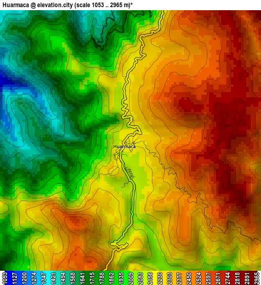
Below is the Elevation map of Huarmaca, which displays elevation range with different colors. Scale of the first map is from 1053 to 2965 m (3455 to 9728 ft) with average elevation of 2171.5 meters (=7124 ft) [note 1]
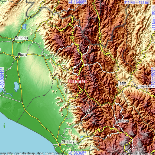
These maps also provides idea of topography and contour of this city, they are displayed at different zoom levels. More info about maps, scale and edge coordinates you can find below images.
| \ | Map #1 | Topo.Map |
| Scale [m] | 1053..2965 m | × |
| Scale [ft] | 3455..9728 ft | × |
| Average | 2171.5 m = 7124 ft | × |
| Width | 9.73 km = 6 mi | 311.2 km = 193.4 mi |
| Height | 9.73 km = 6 mi | 311.2 km = 193.4 mi |
| ↑Max Latitude | -5.52209° | -4.16468° |
| Latitude at center | -5.56583° | -5.56583° |
| ↓Min Latitude | -5.609566° | -6.96365° |
| ← Min Longitude | -79.565885° | -80.92819° |
| Longitude center | -79.52194° | -79.52194° |
| →Max Longitude | -79.477995° | -78.11569° |
Nearby cities:
Cities around Huarmaca sort by population:
• Pueblo Nuevo elevation 170 m
43.4 km,  247°
247°
• Huancabamba 1939 m
37.2 km,  12°
12°
• Pomahuaca 1142 m
51.9 km,  140°
140°
• Yamango 1088 m
50 km,  329°
329°
• Sapalache 2364 m
47.1 km, 11°
• Tunal 1111 m
43.1 km,  336°
336°
• Tabaconas 1895 m
38.5 km,  43°
43°
• San Felipe 1943 m
32.3 km,  133°
133°
• Sondor 2045 m
31 km,  24°
24°
• Sondorillo 1884 m
27.2 km, 21°
• Sallique 1647 m
25.1 km,  113°
113°
• Canchaque 1290 m
23.1 km, 337°
Multilingual:
 En español:
Huarmaca elevación 2211 m.
 En France:
Huarmaca élévation 2211 m.
 Auf Deutsch:
Huarmaca höhe über dem Meeresspiegel ist 2211 m.

Sources and notes:
- [note 1] Map square and city borders are not equal. Map elevation data is calculated only from area inside that square.
- [src 1] Elevation data from geonames database provided with same terms of usage.
- [src 2] The elevation map of Huarmaca is generated using elevation data from NASA's 3 arcsec (90m) resolution SRTM data.
- [src 3] Base (background) map © OpenStreetMap contributors tiles are generated by Geofabrik and OpenTopoMap.
Copyright & License:
This Huarmaca Elevation Map is licensed under CC BY-SA. You may reuse any part from this page, if you give a proper credit by linking to this URL:
 More info on terms of use page.