El Toro elevation
El Toro (Herrera), Panama elevation is 399 meters and El Toro elevation in feet is 1309 ft above sea level [src 1]. El Toro is a seat of a third-order administrative division (feature code) with elevation that is 227 meters (745 ft) bigger than average city elevation in Panama.
Below is the Elevation map of El Toro, which displays elevation range with different colors. Scale of the first map is from 69 to 937 m (226 to 3074 ft) with average elevation of 413.8 meters (=1358 ft) [note 1]
These maps also provides idea of topography and contour of this city, they are displayed at different zoom levels. More info about maps, scale and edge coordinates you can find below images.
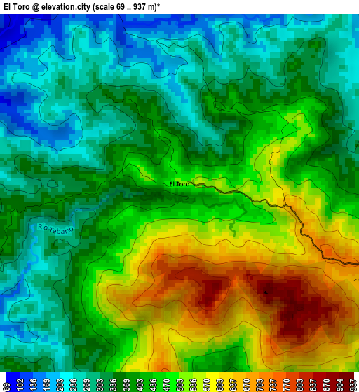
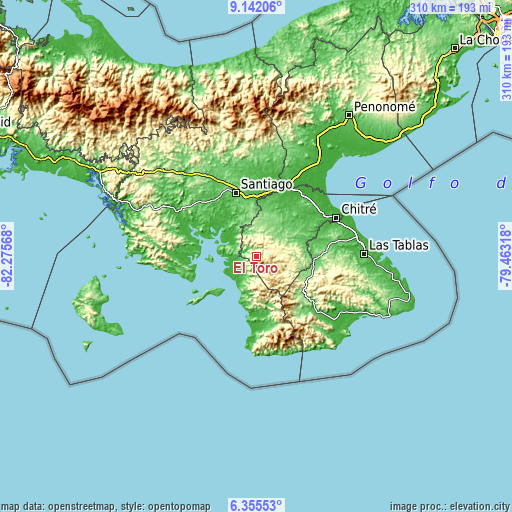
| \ | Map #1 | Topo.Map |
| Scale [m] | 69..937 m | × |
| Scale [ft] | 226..3074 ft | × |
| Average | 413.8 m = 1358 ft | × |
| Width | 9.68 km = 6 mi | 309.8 km = 192.5 mi |
| Height | 9.68 km = 6 mi | 309.9 km = 192.6 mi |
| ↑Max Latitude | 7.794642° | 9.14206° |
| Latitude at center | 7.7511° | 7.7511° |
| ↓Min Latitude | 7.707554° | 6.35553° |
| ← Min Longitude | -80.913375° | -82.27568° |
| Longitude center | -80.86943° | -80.86943° |
| →Max Longitude | -80.825485° | -79.46318° |
Nearby cities:
Cities around El Toro sort by population:
• Ocú elevation 122 m
23.3 km,  25°
25°
• Las Minas 337 m
14.5 km,  69°
69°
• Ponuga 48 m
18.9 km,  320°
320°
• Chumical 128 m
18.9 km,  56°
56°
• Tebario 13 m
12.7 km,  250°
250°
• El Cedro 326 m
24.3 km,  107°
107°
• Cerro Largo 386 m
10.1 km,  24°
24°
• Las Guabas 168 m
18.9 km, 21°
• Quebrada del Rosario 448 m
14.7 km, 107°
• Leones Arriba 481 m
3.1 km, 58°
• Los Cerros de Paja 343 m
22 km,  99°
99°
• Limón de Tijeras 275 m
8.8 km,  326°
326°
Multilingual:
 En español:
El Toro elevación 399 m.
 En France:
El Toro élévation 399 m.


Sources and notes:
- [note 1] Map square and city borders are not equal. Map elevation data is calculated only from area inside that square.
- [src 1] Elevation data from geonames database provided with same terms of usage.
- [src 2] The elevation map of El Toro is generated using elevation data from NASA's 3 arcsec (90m) resolution SRTM data.
- [src 3] Base (background) map © OpenStreetMap contributors tiles are generated by Geofabrik and OpenTopoMap.
Copyright & License:
This El Toro Elevation Map is licensed under CC BY-SA. You may reuse any part from this page, if you give a proper credit by linking to this URL:
 More info on terms of use page.