Los Cerros de Paja elevation
Los Cerros de Paja (Herrera), Panama elevation is 343 meters and Los Cerros de Paja elevation in feet is 1125 ft above sea level [src 1]. Los Cerros de Paja is a seat of a third-order administrative division (feature code) with elevation that is 171 meters (561 ft) bigger than average city elevation in Panama.
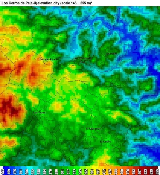
Below is the Elevation map of Los Cerros de Paja, which displays elevation range with different colors. Scale of the first map is from 143 to 555 m (469 to 1821 ft) with average elevation of 295.9 meters (=971 ft) [note 1]
These maps also provides idea of topography and contour of this city, they are displayed at different zoom levels. More info about maps, scale and edge coordinates you can find below images.
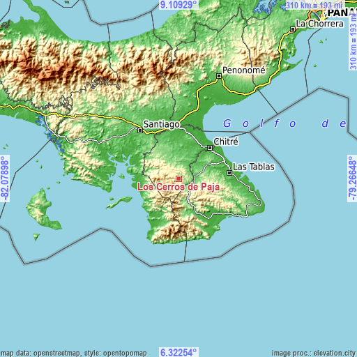
| \ | Map #1 | Topo.Map |
| Scale [m] | 143..555 m | × |
| Scale [ft] | 469..1821 ft | × |
| Average | 295.9 m = 971 ft | × |
| Width | 9.68 km = 6 mi | 309.9 km = 192.6 mi |
| Height | 9.68 km = 6 mi | 309.9 km = 192.6 mi |
| ↑Max Latitude | 7.761755° | 9.10929° |
| Latitude at center | 7.71821° | 7.71821° |
| ↓Min Latitude | 7.674661° | 6.32254° |
| ← Min Longitude | -80.716675° | -82.07898° |
| Longitude center | -80.67273° | -80.67273° |
| →Max Longitude | -80.628785° | -79.26648° |
Nearby cities:
Cities around Los Cerros de Paja sort by population:
• Macaracas elevation 108 m
13.2 km,  83°
83°
• Llano de Piedra 155 m
13.7 km,  118°
118°
• Las Minas 337 m
11.8 km,  317°
317°
• Los Cerritos 119 m
11.2 km,  37°
37°
• Los Pozos 284 m
7.8 km,  22°
22°
• La Mesa 171 m
9.1 km,  138°
138°
• La Arena 105 m
9.5 km,  67°
67°
• Pitaloza Arriba 413 m
8.5 km,  176°
176°
• El Cedro 326 m
3.9 km,  157°
157°
• El Calabacito 222 m
8.3 km,  89°
89°
• El Capurí 268 m
3.3 km, 75°
• Quebrada del Rosario 448 m
7.7 km,  265°
265°
Multilingual:
 En español:
Los Cerros de Paja elevación 343 m.
 En France:
Los Cerros de Paja élévation 343 m.
 Auf Deutsch:
Los Cerros de Paja höhe über dem Meeresspiegel ist 343 m.
 На русском:
Los Cerros de Paja высота над уровнем моря 343 м
Sources and notes:
- [note 1] Map square and city borders are not equal. Map elevation data is calculated only from area inside that square.
- [src 1] Elevation data from geonames database provided with same terms of usage.
- [src 2] The elevation map of Los Cerros de Paja is generated using elevation data from NASA's 3 arcsec (90m) resolution SRTM data.
- [src 3] Base (background) map © OpenStreetMap contributors tiles are generated by Geofabrik and OpenTopoMap.
Copyright & License:
This Los Cerros de Paja Elevation Map is licensed under CC BY-SA. You may reuse any part from this page, if you give a proper credit by linking to this URL:
 More info on terms of use page.