La Mesa elevation
La Mesa (Los Santos), Panama elevation is 171 meters and La Mesa elevation in feet is 561 ft above sea level [src 1]. La Mesa is a seat of a third-order administrative division (feature code) with elevation that is 1 meters (3 ft) smaller than average city elevation in Panama.
Below is the Elevation map of La Mesa, which displays elevation range with different colors. Scale of the first map is from 90 to 513 m (295 to 1683 ft) with average elevation of 200.5 meters (=658 ft) [note 1]
These maps also provides idea of topography and contour of this city, they are displayed at different zoom levels. More info about maps, scale and edge coordinates you can find below images.
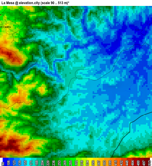
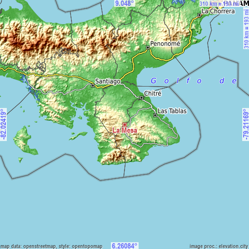
| \ | Map #1 | Topo.Map |
| Scale [m] | 90..513 m | × |
| Scale [ft] | 295..1683 ft | × |
| Average | 200.5 m = 658 ft | × |
| Width | 9.69 km = 6 mi | 309.9 km = 192.6 mi |
| Height | 9.69 km = 6 mi | 309.9 km = 192.6 mi |
| ↑Max Latitude | 7.700251° | 9.048° |
| Latitude at center | 7.6567° | 7.6567° |
| ↓Min Latitude | 7.613144° | 6.26084° |
| ← Min Longitude | -80.661885° | -82.02419° |
| Longitude center | -80.61794° | -80.61794° |
| →Max Longitude | -80.573995° | -79.21169° |
Nearby cities:
Cities around La Mesa sort by population:
• Macaracas elevation 108 m
10.9 km,  40°
40°
• Llano de Piedra 155 m
6 km,  86°
86°
• Los Pozos 284 m
14.4 km,  347°
347°
• La Arena 105 m
10.8 km,  14°
14°
• Pitaloza Arriba 413 m
5.7 km,  253°
253°
• El Cedro 326 m
5.6 km,  305°
305°
• El Calabacito 222 m
7.2 km,  18°
18°
• El Capurí 268 m
8.2 km,  339°
339°
• Los Cerros de Paja 343 m
9.1 km,  318°
318°
• Las Palmas 157 m
13.6 km,  77°
77°
• Altos de Güera 203 m
14.1 km,  181°
181°
• Bajos de Güera 114 m
12.6 km, 183°
Multilingual:
 En español:
La Mesa elevación 171 m.
 En France:
La Mesa élévation 171 m.


Sources and notes:
- [note 1] Map square and city borders are not equal. Map elevation data is calculated only from area inside that square.
- [src 1] Elevation data from geonames database provided with same terms of usage.
- [src 2] The elevation map of La Mesa is generated using elevation data from NASA's 3 arcsec (90m) resolution SRTM data.
- [src 3] Base (background) map © OpenStreetMap contributors tiles are generated by Geofabrik and OpenTopoMap.
Copyright & License:
This La Mesa Elevation Map is licensed under CC BY-SA. You may reuse any part from this page, if you give a proper credit by linking to this URL:
 More info on terms of use page.