Los Pozos elevation
Los Pozos (Herrera), Panama elevation is 284 meters and Los Pozos elevation in feet is 932 ft above sea level [src 1]. Los Pozos is a seat of a second-order administrative division (feature code) with elevation that is 112 meters (367 ft) bigger than average city elevation in Panama.
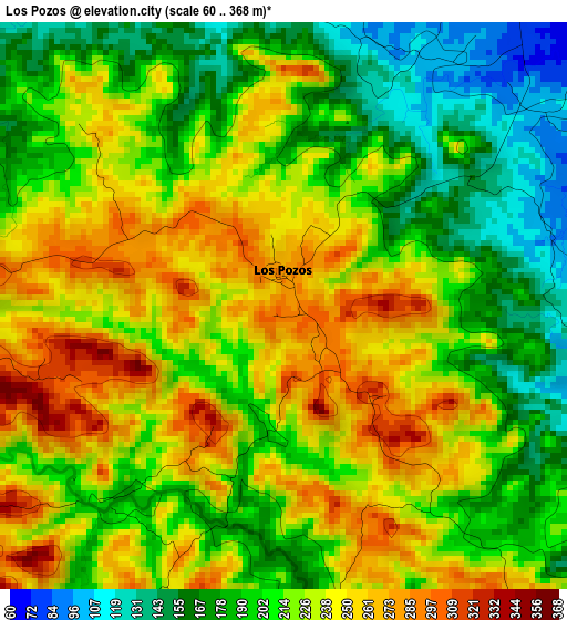
Below is the Elevation map of Los Pozos, which displays elevation range with different colors. Scale of the first map is from 60 to 368 m (197 to 1207 ft) with average elevation of 217.4 meters (=713 ft) [note 1]
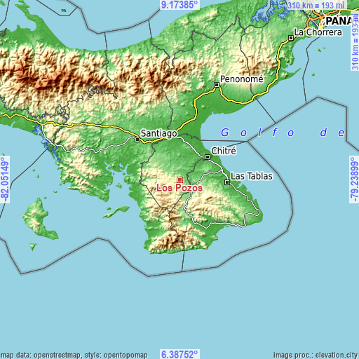
These maps also provides idea of topography and contour of this city, they are displayed at different zoom levels. More info about maps, scale and edge coordinates you can find below images.
| \ | Map #1 | Topo.Map |
| Scale [m] | 60..368 m | × |
| Scale [ft] | 197..1207 ft | × |
| Average | 217.4 m = 713 ft | × |
| Width | 9.68 km = 6 mi | 309.8 km = 192.5 mi |
| Height | 9.68 km = 6 mi | 309.8 km = 192.5 mi |
| ↑Max Latitude | 7.826538° | 9.17385° |
| Latitude at center | 7.783° | 7.783° |
| ↓Min Latitude | 7.739457° | 6.38752° |
| ← Min Longitude | -80.689185° | -82.05149° |
| Longitude center | -80.64524° | -80.64524° |
| →Max Longitude | -80.601295° | -79.23899° |
Nearby cities:
Cities around Los Pozos sort by population:
• Las Minas elevation 337 m
11.2 km,  277°
277°
• Sabana Grande 134 m
10.8 km,  4°
4°
• Los Cerritos 119 m
4.1 km,  67°
67°
• Chumical 128 m
11.3 km,  307°
307°
• Rincón Hondo 58 m
8.2 km,  33°
33°
• La Arena 105 m
6.8 km,  122°
122°
• El Cedro 326 m
10.9 km,  188°
188°
• La Colorada 57 m
10.9 km, 65°
• El Calabacito 222 m
8.9 km,  143°
143°
• El Capurí 268 m
6.4 km,  178°
178°
• Los Cerros de Paja 343 m
7.8 km,  202°
202°
• Chupá 90 m
8 km,  76°
76°
Multilingual:
 En español:
Los Pozos elevación 284 m.
 En France:
Los Pozos élévation 284 m.
 Auf Deutsch:
Los Pozos höhe über dem Meeresspiegel ist 284 m.

Sources and notes:
- [note 1] Map square and city borders are not equal. Map elevation data is calculated only from area inside that square.
- [src 1] Elevation data from geonames database provided with same terms of usage.
- [src 2] The elevation map of Los Pozos is generated using elevation data from NASA's 3 arcsec (90m) resolution SRTM data.
- [src 3] Base (background) map © OpenStreetMap contributors tiles are generated by Geofabrik and OpenTopoMap.
Copyright & License:
This Los Pozos Elevation Map is licensed under CC BY-SA. You may reuse any part from this page, if you give a proper credit by linking to this URL:
 More info on terms of use page.