Tebario elevation
Tebario (Veraguas), Panama elevation is 13 meters and Tebario elevation in feet is 43 ft above sea level [src 1]. Tebario is a seat of a third-order administrative division (feature code) with elevation that is 159 meters (522 ft) smaller than average city elevation in Panama.
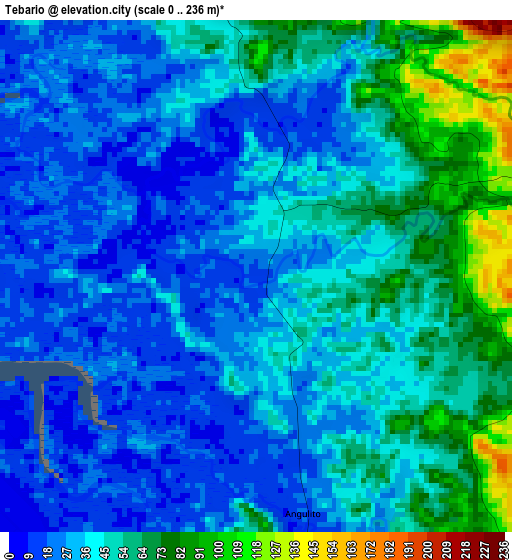
Below is the Elevation map of Tebario, which displays elevation range with different colors. Scale of the first map is from 0 to 236 m (0 to 774 ft) with average elevation of 42 meters (=138 ft) [note 1]
These maps also provides idea of topography and contour of this city, they are displayed at different zoom levels. More info about maps, scale and edge coordinates you can find below images.
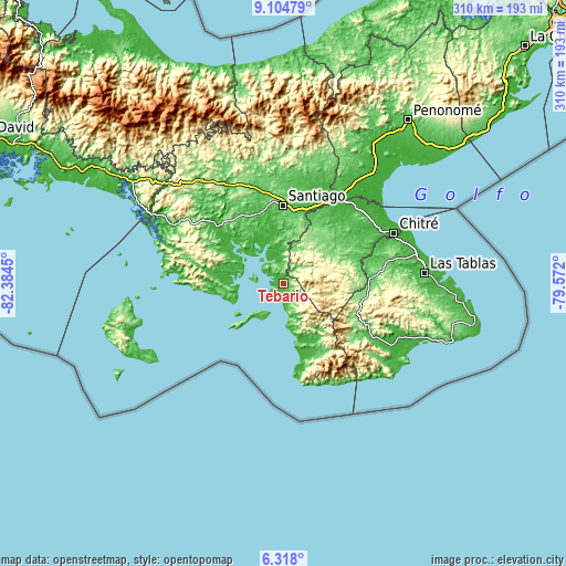
| \ | Map #1 | Topo.Map |
| Scale [m] | 0..236 m | × |
| Scale [ft] | 0..774 ft | × |
| Average | 42 m = 138 ft | × |
| Width | 9.68 km = 6 mi | 309.9 km = 192.6 mi |
| Height | 9.68 km = 6 mi | 309.9 km = 192.6 mi |
| ↑Max Latitude | 7.757235° | 9.10479° |
| Latitude at center | 7.71369° | 7.71369° |
| ↓Min Latitude | 7.67014° | 6.318° |
| ← Min Longitude | -81.022195° | -82.3845° |
| Longitude center | -80.97825° | -80.97825° |
| →Max Longitude | -80.934305° | -79.572° |
Nearby cities:
Cities around Tebario sort by population:
• Las Minas elevation 337 m
27.2 km,  70°
70°
• Ponuga 48 m
18.8 km,  359°
359°
• El Barrito 138 m
27.7 km,  6°
6°
• Las Huacas 32 m
27.5 km,  319°
319°
• El Toro 399 m
12.7 km, 70°
• Cerro Largo 386 m
21 km,  50°
50°
• Las Guabas 168 m
28.8 km,  40°
40°
• Quebrada del Rosario 448 m
26 km,  90°
90°
• La Garceana 58 m
25.2 km,  350°
350°
• Leones Arriba 481 m
15.8 km, 68°
• Leones Arriba 15 m
15.8 km,  286°
286°
• Limón de Tijeras 275 m
13.6 km,  31°
31°
Multilingual:
 En español:
Tebario elevación 13 m.
 En France:
Tebario élévation 13 m.


Sources and notes:
- [note 1] Map square and city borders are not equal. Map elevation data is calculated only from area inside that square.
- [src 1] Elevation data from geonames database provided with same terms of usage.
- [src 2] The elevation map of Tebario is generated using elevation data from NASA's 3 arcsec (90m) resolution SRTM data.
- [src 3] Base (background) map © OpenStreetMap contributors tiles are generated by Geofabrik and OpenTopoMap.
Copyright & License:
This Tebario Elevation Map is licensed under CC BY-SA. You may reuse any part from this page, if you give a proper credit by linking to this URL:
 More info on terms of use page.