Las Huacas elevation
Las Huacas (Veraguas), Panama elevation is 32 meters and Las Huacas elevation in feet is 105 ft above sea level [src 1]. Las Huacas is a seat of a third-order administrative division (feature code) with elevation that is 140 meters (459 ft) smaller than average city elevation in Panama.
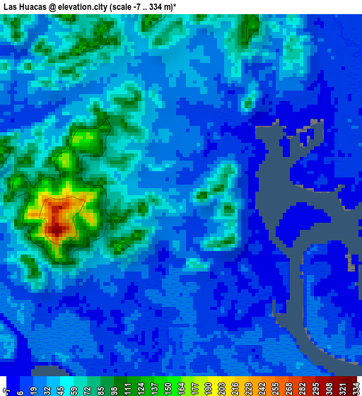
Below is the Elevation map of Las Huacas, which displays elevation range with different colors. Scale of the first map is from -7 to 334 m (-23 to 1096 ft) with average elevation of 38.8 meters (=127 ft) [note 1]
These maps also provides idea of topography and contour of this city, they are displayed at different zoom levels. More info about maps, scale and edge coordinates you can find below images.
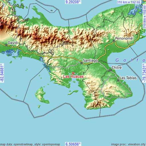
| \ | Map #1 | Topo.Map |
| Scale [m] | -7..334 m | × |
| Scale [ft] | -23..1096 ft | × |
| Average | 38.8 m = 127 ft | × |
| Width | 9.68 km = 6 mi | 309.7 km = 192.4 mi |
| Height | 9.68 km = 6 mi | 309.8 km = 192.5 mi |
| ↑Max Latitude | 7.945196° | 9.29208° |
| Latitude at center | 7.90167° | 7.90167° |
| ↓Min Latitude | 7.85814° | 6.50656° |
| ← Min Longitude | -81.184505° | -82.54681° |
| Longitude center | -81.14056° | -81.14056° |
| →Max Longitude | -81.096615° | -79.73431° |
Nearby cities:
Cities around Las Huacas sort by population:
• Montijo elevation 61 m
13.4 km,  43°
43°
• Río de Jesús 82 m
8.9 km,  344°
344°
• Los Castillos 56 m
13.7 km,  9°
9°
• Ponuga 48 m
17.9 km,  96°
96°
• Guarumal 37 m
17.7 km,  227°
227°
• Utirá 68 m
11.6 km,  312°
312°
• El Marañón 73 m
17 km,  331°
331°
• El Pájaro 57 m
6.1 km,  20°
20°
• La Garceana 58 m
14.2 km,  73°
73°
• Leones Arriba 15 m
16.6 km,  170°
170°
• La Soledad 29 m
15.1 km,  260°
260°
• El Pilón 42 m
9.2 km,  50°
50°
Multilingual:
 En español:
Las Huacas elevación 32 m.
 En France:
Las Huacas élévation 32 m.
 Auf Deutsch:
Las Huacas höhe über dem Meeresspiegel ist 32 m.

Sources and notes:
- [note 1] Map square and city borders are not equal. Map elevation data is calculated only from area inside that square.
- [src 1] Elevation data from geonames database provided with same terms of usage.
- [src 2] The elevation map of Las Huacas is generated using elevation data from NASA's 3 arcsec (90m) resolution SRTM data.
- [src 3] Base (background) map © OpenStreetMap contributors tiles are generated by Geofabrik and OpenTopoMap.
Copyright & License:
This Las Huacas Elevation Map is licensed under CC BY-SA. You may reuse any part from this page, if you give a proper credit by linking to this URL:
 More info on terms of use page.