Ocú elevation
Ocú (Herrera), Panama elevation is 122 meters and Ocú elevation in feet is 400 ft above sea level [src 1]. Ocú is a seat of a second-order administrative division (feature code) with elevation that is 50 meters (164 ft) smaller than average city elevation in Panama.
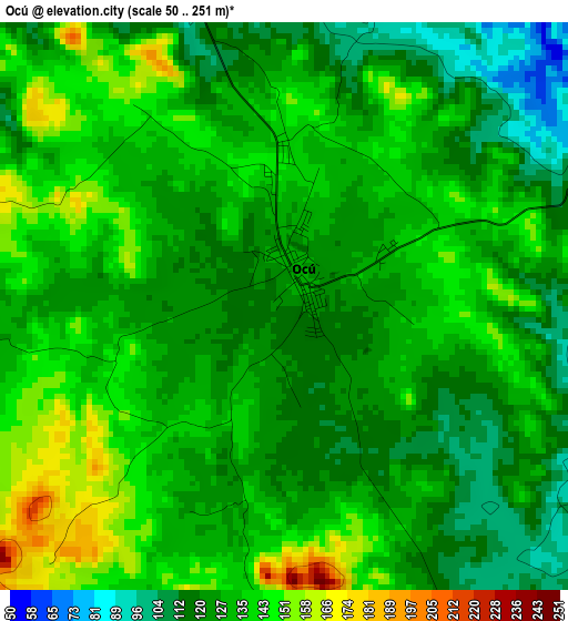
Below is the Elevation map of Ocú, which displays elevation range with different colors. Scale of the first map is from 50 to 251 m (164 to 823 ft) with average elevation of 130.9 meters (=429 ft) [note 1]
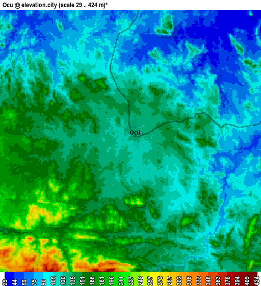
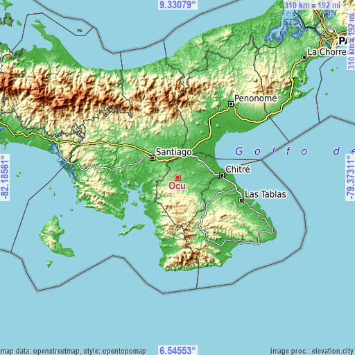
These maps also provides idea of topography and contour of this city, they are displayed at different zoom levels. More info about maps, scale and edge coordinates you can find below images.
| \ | Map #1 | Map #2 | Topo.Map |
| Scale [m] | 50..251 m | 29..424 m | × |
| Scale [ft] | 164..823 ft | 95..1391 ft | × |
| Average | 130.9 m = 429 ft | 127.7 m = 419 ft | × |
| Width | 9.68 km = 6 mi | 19.36 km = 12 mi | 309.7 km = 192.4 mi |
| Height | 9.68 km = 6 mi | 19.36 km = 12 mi | 309.7 km = 192.4 mi |
| ↑Max Latitude | 7.984042° | 8.027559° | 9.33079° |
| Latitude at center | 7.94052° | 7.94052° | 7.94052° |
| ↓Min Latitude | 7.896994° | 7.853463° | 6.54553° |
| ← Min Longitude | -80.823305° | -80.867251° | -82.18561° |
| Longitude center | -80.77936° | -80.77936° | -80.77936° |
| →Max Longitude | -80.735415° | -80.691469° | -79.37311° |
Nearby cities:
Cities around Ocú sort by population:
• Chupampa elevation 63 m
15.1 km,  1°
1°
• Chumical 128 m
12.1 km,  151°
151°
• Peñas Chatas 88 m
8.7 km,  342°
342°
• La Montañuela 63 m
13.2 km,  315°
315°
• Llano Grande 74 m
8.4 km,  63°
63°
• Llano de La Cruz 36 m
15.1 km,  85°
85°
• Cerro Largo 386 m
13.2 km,  205°
205°
• Las Guabas 168 m
4.6 km,  221°
221°
• La Trinidad 90 m
8.9 km,  109°
109°
• El Limón 68 m
13.1 km, 3°
• La Carrillo 174 m
11.9 km,  285°
285°
• Cabuya 94 m
5 km,  19°
19°
Multilingual:
 En español:
Ocú elevación 122 m.
 En France:
Ocú élévation 122 m.


Sources and notes:
- [note 1] Map square and city borders are not equal. Map elevation data is calculated only from area inside that square.
- [src 1] Elevation data from geonames database provided with same terms of usage.
- [src 2] The elevation map of Ocú is generated using elevation data from NASA's 3 arcsec (90m) resolution SRTM data.
- [src 3] Base (background) map © OpenStreetMap contributors tiles are generated by Geofabrik and OpenTopoMap.
Copyright & License:
This Ocú Elevation Map is licensed under CC BY-SA. You may reuse any part from this page, if you give a proper credit by linking to this URL:
 More info on terms of use page.