La Carrillo elevation
La Carrillo (Veraguas), Panama elevation is 174 meters and La Carrillo elevation in feet is 571 ft above sea level [src 1]. La Carrillo is a seat of a third-order administrative division (feature code) with elevation that is 2 meters (7 ft) bigger than average city elevation in Panama.
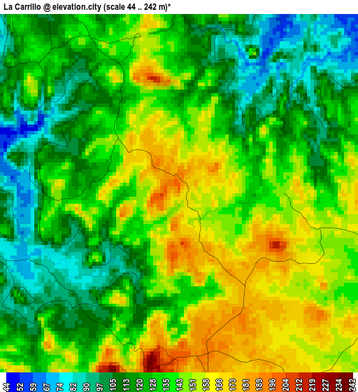
Below is the Elevation map of La Carrillo, which displays elevation range with different colors. Scale of the first map is from 44 to 242 m (144 to 794 ft) with average elevation of 132.7 meters (=435 ft) [note 1]
These maps also provides idea of topography and contour of this city, they are displayed at different zoom levels. More info about maps, scale and edge coordinates you can find below images.
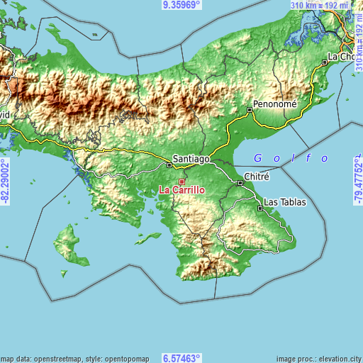
| \ | Map #1 | Topo.Map |
| Scale [m] | 44..242 m | × |
| Scale [ft] | 144..794 ft | × |
| Average | 132.7 m = 435 ft | × |
| Width | 9.68 km = 6 mi | 309.7 km = 192.4 mi |
| Height | 9.68 km = 6 mi | 309.7 km = 192.4 mi |
| ↑Max Latitude | 8.013049° | 9.35969° |
| Latitude at center | 7.96953° | 7.96953° |
| ↓Min Latitude | 7.926007° | 6.57463° |
| ← Min Longitude | -80.927715° | -82.29002° |
| Longitude center | -80.88377° | -80.88377° |
| →Max Longitude | -80.839825° | -79.47752° |
Nearby cities:
Cities around La Carrillo sort by population:
• Ocú elevation 122 m
11.9 km,  105°
105°
• Atalaya 95 m
9.3 km,  330°
330°
• La Colorada 103 m
12.2 km,  293°
293°
• El Espino de Santa Rosa 48 m
15.2 km,  25°
25°
• Ponuga 48 m
14.3 km,  227°
227°
• Peñas Chatas 88 m
10.2 km,  60°
60°
• La Montañuela 63 m
6.6 km,  20°
20°
• El Barrito 138 m
7.1 km,  262°
262°
• Las Guabas 168 m
10.8 km,  128°
128°
• La Garceana 58 m
15 km, 256°
• Cabuya 94 m
13.2 km,  83°
83°
• San Antonio 92 m
12.7 km,  335°
335°
Multilingual:
 En español:
La Carrillo elevación 174 m.
 En France:
La Carrillo élévation 174 m.
 Auf Deutsch:
La Carrillo höhe über dem Meeresspiegel ist 174 m.

Sources and notes:
- [note 1] Map square and city borders are not equal. Map elevation data is calculated only from area inside that square.
- [src 1] Elevation data from geonames database provided with same terms of usage.
- [src 2] The elevation map of La Carrillo is generated using elevation data from NASA's 3 arcsec (90m) resolution SRTM data.
- [src 3] Base (background) map © OpenStreetMap contributors tiles are generated by Geofabrik and OpenTopoMap.
Copyright & License:
This La Carrillo Elevation Map is licensed under CC BY-SA. You may reuse any part from this page, if you give a proper credit by linking to this URL:
 More info on terms of use page.