El Espino de Santa Rosa elevation
El Espino de Santa Rosa (Veraguas), Panama elevation is 48 meters and El Espino de Santa Rosa elevation in feet is 157 ft above sea level [src 1]. El Espino de Santa Rosa is a populated place (feature code) with elevation that is 124 meters (407 ft) smaller than average city elevation in Panama.
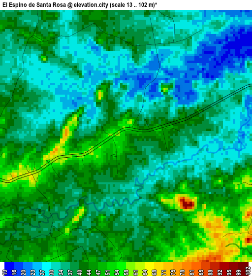
Below is the Elevation map of El Espino de Santa Rosa, which displays elevation range with different colors. Scale of the first map is from 13 to 102 m (43 to 335 ft) with average elevation of 38.9 meters (=128 ft) [note 1]
These maps also provides idea of topography and contour of this city, they are displayed at different zoom levels. More info about maps, scale and edge coordinates you can find below images.
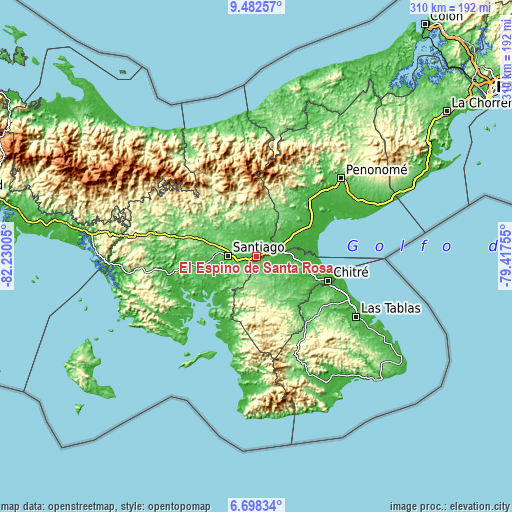
| \ | Map #1 | Topo.Map |
| Scale [m] | 13..102 m | × |
| Scale [ft] | 43..335 ft | × |
| Average | 38.9 m = 128 ft | × |
| Width | 9.68 km = 6 mi | 309.6 km = 192.4 mi |
| Height | 9.68 km = 6 mi | 309.6 km = 192.4 mi |
| ↑Max Latitude | 8.136365° | 9.48257° |
| Latitude at center | 8.09286° | 8.09286° |
| ↓Min Latitude | 8.04935° | 6.69834° |
| ← Min Longitude | -80.867745° | -82.23005° |
| Longitude center | -80.8238° | -80.8238° |
| →Max Longitude | -80.779855° | -79.41755° |
Nearby cities:
Cities around El Espino de Santa Rosa sort by population:
• Atalaya elevation 95 m
12.5 km,  243°
243°
• Los Canelos 26 m
13.1 km,  78°
78°
• La Raya de Santa María 42 m
7.9 km,  1°
1°
• Chupampa 63 m
5.5 km,  109°
109°
• Las Guías Abajo 34 m
13.6 km,  33°
33°
• Peñas Chatas 88 m
8.9 km,  165°
165°
• La Montañuela 63 m
8.7 km,  209°
209°
• La Raya de Calobre 53 m
13.7 km,  358°
358°
• Los Higos 52 m
13.2 km,  342°
342°
• Cabuya 94 m
13.9 km,  151°
151°
• San Antonio 92 m
12.1 km,  259°
259°
• El Limón 68 m
6.8 km,  124°
124°
Multilingual:
 En español:
El Espino de Santa Rosa elevación 48 m.
 En France:
El Espino de Santa Rosa élévation 48 m.
 Auf Deutsch:
El Espino de Santa Rosa höhe über dem Meeresspiegel ist 48 m.
 На русском:
El Espino de Santa Rosa высота над уровнем моря 48 м
Sources and notes:
- [note 1] Map square and city borders are not equal. Map elevation data is calculated only from area inside that square.
- [src 1] Elevation data from geonames database provided with same terms of usage.
- [src 2] The elevation map of El Espino de Santa Rosa is generated using elevation data from NASA's 3 arcsec (90m) resolution SRTM data.
- [src 3] Base (background) map © OpenStreetMap contributors tiles are generated by Geofabrik and OpenTopoMap.
Copyright & License:
This El Espino de Santa Rosa Elevation Map is licensed under CC BY-SA. You may reuse any part from this page, if you give a proper credit by linking to this URL:
 More info on terms of use page.