Los Higos elevation
Los Higos (Veraguas), Panama elevation is 52 meters and Los Higos elevation in feet is 171 ft above sea level [src 1]. Los Higos is a seat of a third-order administrative division (feature code) with elevation that is 120 meters (394 ft) smaller than average city elevation in Panama.
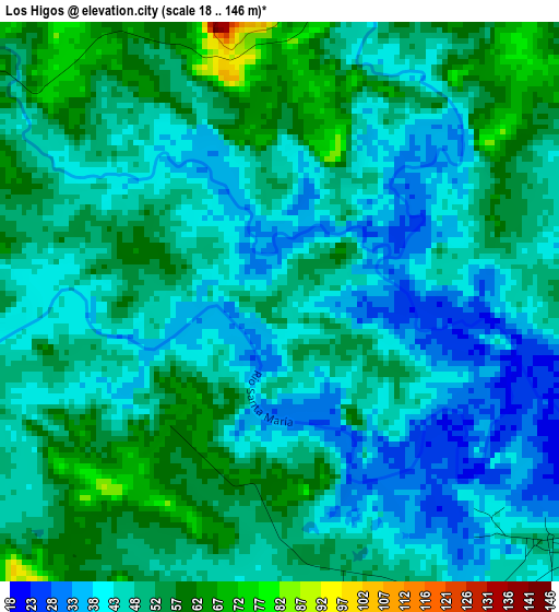
Below is the Elevation map of Los Higos, which displays elevation range with different colors. Scale of the first map is from 18 to 146 m (59 to 479 ft) with average elevation of 47.6 meters (=156 ft) [note 1]
These maps also provides idea of topography and contour of this city, they are displayed at different zoom levels. More info about maps, scale and edge coordinates you can find below images.
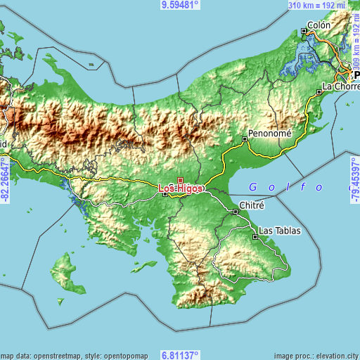
| \ | Map #1 | Topo.Map |
| Scale [m] | 18..146 m | × |
| Scale [ft] | 59..479 ft | × |
| Average | 47.6 m = 156 ft | × |
| Width | 9.67 km = 6 mi | 309.5 km = 192.3 mi |
| Height | 9.67 km = 6 mi | 309.5 km = 192.3 mi |
| ↑Max Latitude | 8.249023° | 9.59481° |
| Latitude at center | 8.20553° | 8.20553° |
| ↓Min Latitude | 8.162032° | 6.81137° |
| ← Min Longitude | -80.904165° | -82.26647° |
| Longitude center | -80.86022° | -80.86022° |
| →Max Longitude | -80.816275° | -79.45397° |
Nearby cities:
Cities around Los Higos sort by population:
• Canto del Llano elevation 111 m
14.5 km,  231°
231°
• San Francisco 88 m
13.4 km,  289°
289°
• El Espino de Santa Rosa 48 m
13.2 km,  162°
162°
• El Uvito 85 m
16.9 km, 234°
• Calobre 125 m
12.8 km,  9°
9°
• La Raya de Santa María 42 m
6.3 km,  137°
137°
• Chupampa 63 m
17.1 km,  147°
147°
• Las Guías Abajo 34 m
11.7 km,  96°
96°
• La Raya de Calobre 53 m
3.8 km,  71°
71°
• Boquerón 70 m
4.3 km,  1°
1°
• El Coclá 250 m
14.5 km,  332°
332°
• San Antonio 92 m
16.7 km,  208°
208°
Multilingual:
 En español:
Los Higos elevación 52 m.
 En France:
Los Higos élévation 52 m.
 Auf Deutsch:
Los Higos höhe über dem Meeresspiegel ist 52 m.

Sources and notes:
- [note 1] Map square and city borders are not equal. Map elevation data is calculated only from area inside that square.
- [src 1] Elevation data from geonames database provided with same terms of usage.
- [src 2] The elevation map of Los Higos is generated using elevation data from NASA's 3 arcsec (90m) resolution SRTM data.
- [src 3] Base (background) map © OpenStreetMap contributors tiles are generated by Geofabrik and OpenTopoMap.
Copyright & License:
This Los Higos Elevation Map is licensed under CC BY-SA. You may reuse any part from this page, if you give a proper credit by linking to this URL:
 More info on terms of use page.