El Uvito elevation
El Uvito (Veraguas), Panama elevation is 85 meters and El Uvito elevation in feet is 279 ft above sea level [src 1]. El Uvito is a populated place (feature code) with elevation that is 87 meters (285 ft) smaller than average city elevation in Panama.
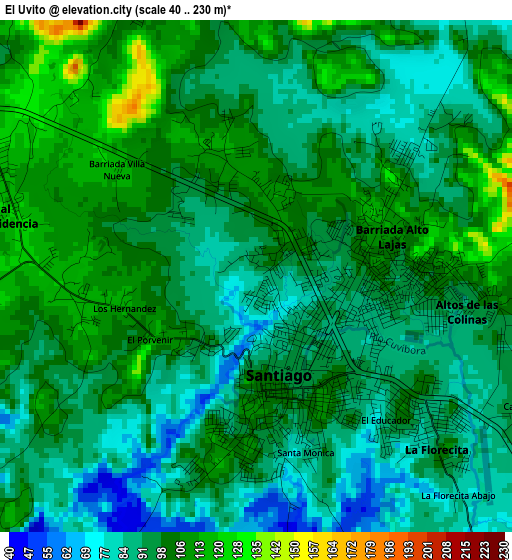
Below is the Elevation map of El Uvito, which displays elevation range with different colors. Scale of the first map is from 40 to 230 m (131 to 755 ft) with average elevation of 96.6 meters (=317 ft) [note 1]
These maps also provides idea of topography and contour of this city, they are displayed at different zoom levels. More info about maps, scale and edge coordinates you can find below images.
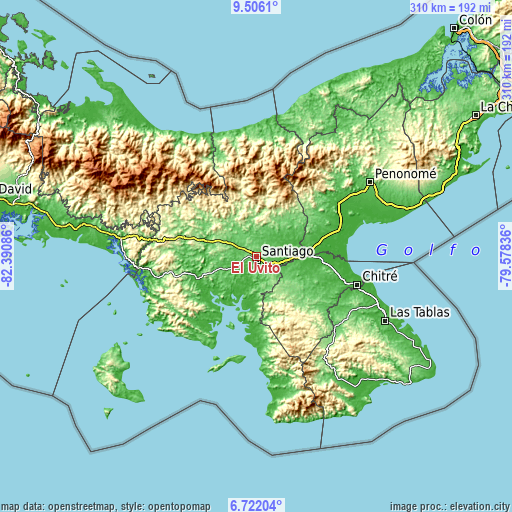
| \ | Map #1 | Topo.Map |
| Scale [m] | 40..230 m | × |
| Scale [ft] | 131..755 ft | × |
| Average | 96.6 m = 317 ft | × |
| Width | 9.67 km = 6 mi | 309.6 km = 192.4 mi |
| Height | 9.67 km = 6 mi | 309.6 km = 192.4 mi |
| ↑Max Latitude | 8.159983° | 9.5061° |
| Latitude at center | 8.11648° | 8.11648° |
| ↓Min Latitude | 8.072973° | 6.72204° |
| ← Min Longitude | -81.028555° | -82.39086° |
| Longitude center | -80.98461° | -80.98461° |
| →Max Longitude | -80.940665° | -79.57836° |
Nearby cities:
Cities around El Uvito sort by population:
• Santiago de Veraguas elevation 100 m
1.8 km,  175°
175°
• Canto del Llano 111 m
2.5 km,  68°
68°
• Atalaya 95 m
10.5 km,  141°
141°
• La Peña 121 m
4.8 km,  285°
285°
• Los Algarrobos 115 m
3.3 km,  255°
255°
• Montijo 61 m
16.3 km,  209°
209°
• San Francisco 88 m
14.5 km,  4°
4°
• La Colorada 103 m
11.5 km, 180°
• San Pedro del Espino 63 m
11.5 km,  283°
283°
• La Montañuela 63 m
16.8 km,  127°
127°
• Los Higos 52 m
16.9 km,  54°
54°
• San Antonio 92 m
7.6 km, 129°
Multilingual:
 En español:
El Uvito elevación 85 m.
 En France:
El Uvito élévation 85 m.


Sources and notes:
- [note 1] Map square and city borders are not equal. Map elevation data is calculated only from area inside that square.
- [src 1] Elevation data from geonames database provided with same terms of usage.
- [src 2] The elevation map of El Uvito is generated using elevation data from NASA's 3 arcsec (90m) resolution SRTM data.
- [src 3] Base (background) map © OpenStreetMap contributors tiles are generated by Geofabrik and OpenTopoMap.
Copyright & License:
This El Uvito Elevation Map is licensed under CC BY-SA. You may reuse any part from this page, if you give a proper credit by linking to this URL:
 More info on terms of use page.