Biratnagar elevation
Biratnagar (Eastern Region, Kosī Zone), Nepal elevation is 74 meters and Biratnagar elevation in feet is 243 ft above sea level [src 1]. Biratnagar is a populated place (feature code) with elevation that is 885 meters (2904 ft) smaller than average city elevation in Nepal.
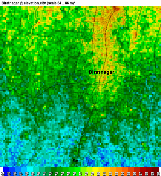
Below is the Elevation map of Biratnagar, which displays elevation range with different colors. Scale of the first map is from 64 to 86 m (210 to 282 ft) with average elevation of 73.1 meters (=240 ft) [note 1]
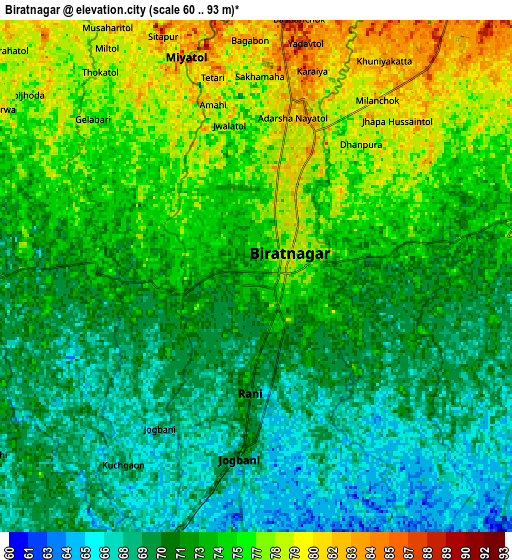
These maps also provides idea of topography and contour of this city, they are displayed at different zoom levels. More info about maps, scale and edge coordinates you can find below images.
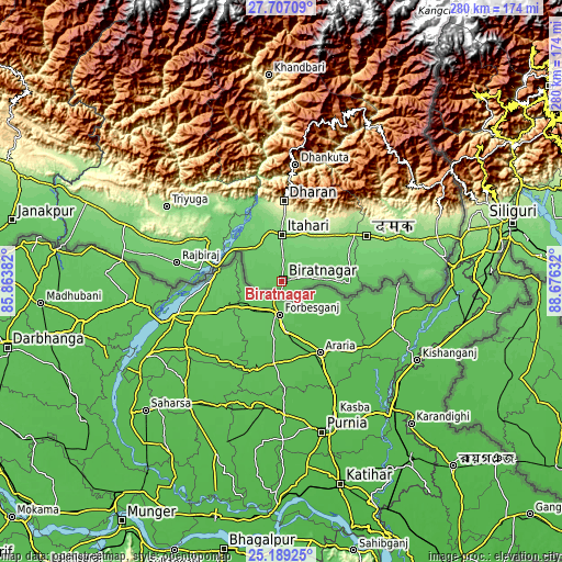
| \ | Map #1 | Map #2 | Topo.Map |
| Scale [m] | 64..86 m | 60..93 m | × |
| Scale [ft] | 210..282 ft | 197..305 ft | × |
| Average | 73.1 m = 240 ft | 72.9 m = 239 ft | × |
| Width | 8.75 km = 5.4 mi | 17.5 km = 10.9 mi | 280 km = 174 mi |
| Height | 8.75 km = 5.4 mi | 17.5 km = 10.9 mi | 280 km = 174 mi |
| ↑Max Latitude | 26.494387° | 26.53371° | 27.70709° |
| Latitude at center | 26.45505° | 26.45505° | 26.45505° |
| ↓Min Latitude | 26.4157° | 26.376336° | 25.18925° |
| ← Min Longitude | 87.226125° | 87.182179° | 85.86382° |
| Longitude center | 87.27007° | 87.27007° | 87.27007° |
| →Max Longitude | 87.314015° | 87.357961° | 88.67632° |
Nearby cities:
Cities around Biratnagar sort by population:
• Dharān elevation 375 m
40 km,  1°
1°
• Triyuga 165 m
68 km,  303°
303°
• Inaruwa 87 m
20.8 km,  324°
324°
• Titahari 118 m
23.2 km, 0°
• Rājbirāj 89 m
52.8 km,  280°
280°
• Lahān 123 m
83.7 km,  290°
290°
• Siraha 82 m
107.9 km, 281°
• Khanbari 892 m
102.6 km,  356°
356°
• Dhankutā 1188 m
59.1 km,  6°
6°
• Bhadrapur 91 m
82.6 km,  83°
83°
• Ilām 1218 m
82.6 km,  52°
52°
• Bhojpur 1573 m
82.7 km,  344°
344°
Multilingual:
 En español:
Biratnagar elevación 74 m.
 En France:
Biratnagar élévation 74 m.
 Auf Deutsch:
Biratnagar höhe über dem Meeresspiegel ist 74 m.

Sources and notes:
- [note 1] Map square and city borders are not equal. Map elevation data is calculated only from area inside that square.
- [src 1] Elevation data from geonames database provided with same terms of usage.
- [src 2] The elevation map of Biratnagar is generated using elevation data from NASA's 3 arcsec (90m) resolution SRTM data.
- [src 3] Base (background) map © OpenStreetMap contributors tiles are generated by Geofabrik and OpenTopoMap.
Copyright & License:
This Biratnagar Elevation Map is licensed under CC BY-SA. You may reuse any part from this page, if you give a proper credit by linking to this URL:
 More info on terms of use page.