Ilām elevation
Ilām (Eastern Region, Mechī Zone), Nepal elevation is 1218 meters and Ilām elevation in feet is 3996 ft above sea level [src 1]. Ilām is a seat of a third-order administrative division (feature code) with elevation that is 259 meters (850 ft) bigger than average city elevation in Nepal.
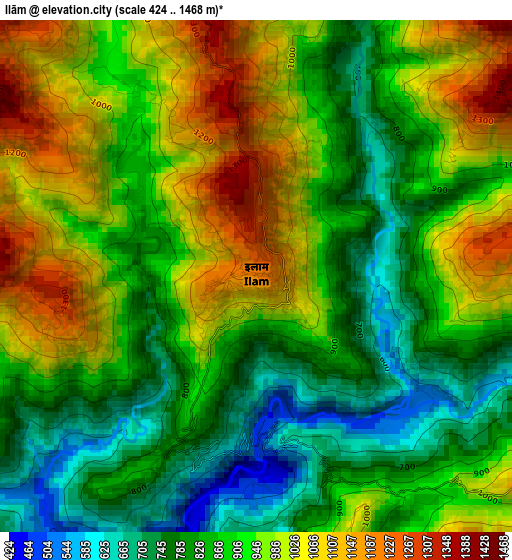
Below is the Elevation map of Ilām, which displays elevation range with different colors. Scale of the first map is from 424 to 1468 m (1391 to 4816 ft) with average elevation of 909.4 meters (=2984 ft) [note 1]
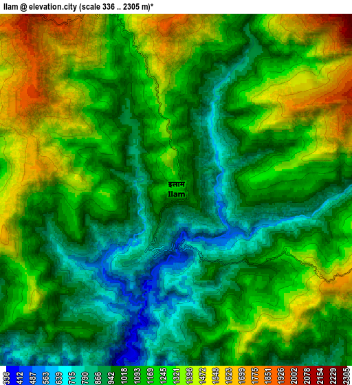
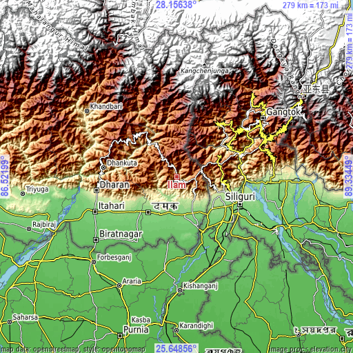
These maps also provides idea of topography and contour of this city, they are displayed at different zoom levels. More info about maps, scale and edge coordinates you can find below images.
| \ | Map #1 | Map #2 | Topo.Map |
| Scale [m] | 424..1468 m | 336..2305 m | × |
| Scale [ft] | 1391..4816 ft | 1102..7562 ft | × |
| Average | 909.4 m = 2984 ft | 1146.7 m = 3762 ft | × |
| Width | 8.71 km = 5.4 mi | 17.43 km = 10.8 mi | 278.8 km = 173.2 mi |
| Height | 8.71 km = 5.4 mi | 17.43 km = 10.8 mi | 278.9 km = 173.3 mi |
| ↑Max Latitude | 26.94861° | 26.987777° | 28.15638° |
| Latitude at center | 26.90943° | 26.90943° | 26.90943° |
| ↓Min Latitude | 26.870236° | 26.831029° | 25.64856° |
| ← Min Longitude | 87.884295° | 87.840349° | 86.52199° |
| Longitude center | 87.92824° | 87.92824° | 87.92824° |
| →Max Longitude | 87.972185° | 88.016131° | 89.33449° |
Nearby cities:
Cities around Ilām sort by population:
• Biratnagar elevation 74 m
82.6 km,  232°
232°
• Dharān 375 m
65.2 km,  260°
260°
• Triyuga 165 m
122.6 km, 263°
• Inaruwa 87 m
84.5 km,  246°
246°
• Titahari 118 m
70.4 km, 247°
• Rājbirāj 89 m
124.2 km, 250°
• Lahān 123 m
145 km, 261°
• Khanbari 892 m
88.2 km,  306°
306°
• Dhankutā 1188 m
59.5 km,  277°
277°
• Bhadrapur 91 m
43.8 km,  157°
157°
• Bhojpur 1573 m
92.1 km,  288°
288°
• Namche Bazar 3433 m
156.1 km, 309°
Multilingual:
 En español:
Ilām elevación 1218 m.
 En France:
Ilām élévation 1218 m.


Sources and notes:
- [note 1] Map square and city borders are not equal. Map elevation data is calculated only from area inside that square.
- [src 1] Elevation data from geonames database provided with same terms of usage.
- [src 2] The elevation map of Ilām is generated using elevation data from NASA's 3 arcsec (90m) resolution SRTM data.
- [src 3] Base (background) map © OpenStreetMap contributors tiles are generated by Geofabrik and OpenTopoMap.
Copyright & License:
This Ilām Elevation Map is licensed under CC BY-SA. You may reuse any part from this page, if you give a proper credit by linking to this URL:
 More info on terms of use page.