Rājbirāj elevation
Rājbirāj (Eastern Region), Nepal elevation is 89 meters and Rājbirāj elevation in feet is 292 ft above sea level [src 1]. Rājbirāj is a populated place (feature code) with elevation that is 870 meters (2854 ft) smaller than average city elevation in Nepal.
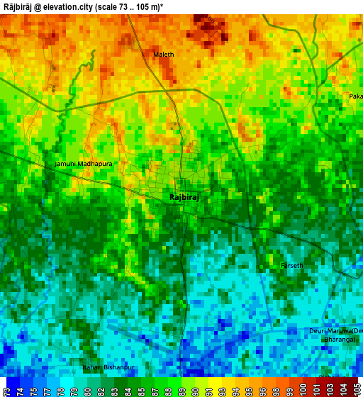
Below is the Elevation map of Rājbirāj, which displays elevation range with different colors. Scale of the first map is from 73 to 105 m (240 to 344 ft) with average elevation of 86.2 meters (=283 ft) [note 1]
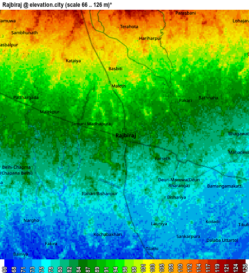
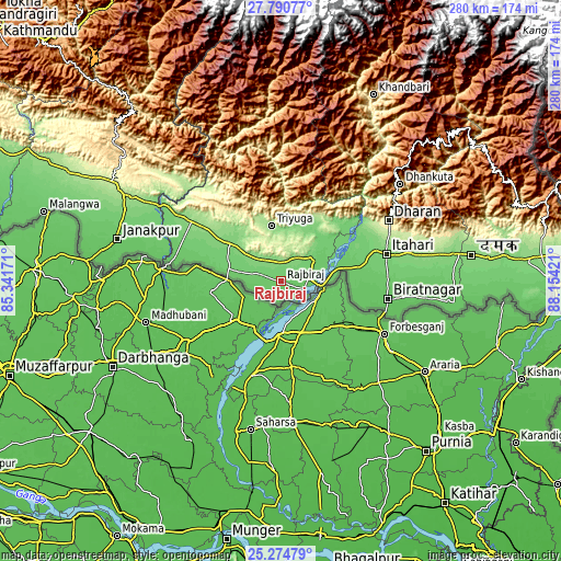
These maps also provides idea of topography and contour of this city, they are displayed at different zoom levels. More info about maps, scale and edge coordinates you can find below images.
| \ | Map #1 | Map #2 | Topo.Map |
| Scale [m] | 73..105 m | 66..126 m | × |
| Scale [ft] | 240..344 ft | 217..413 ft | × |
| Average | 86.2 m = 283 ft | 87.1 m = 286 ft | × |
| Width | 8.74 km = 5.4 mi | 17.49 km = 10.9 mi | 279.8 km = 173.9 mi |
| Height | 8.74 km = 5.4 mi | 17.49 km = 10.9 mi | 279.8 km = 173.9 mi |
| ↑Max Latitude | 26.578988° | 26.618282° | 27.79077° |
| Latitude at center | 26.53968° | 26.53968° | 26.53968° |
| ↓Min Latitude | 26.500359° | 26.461024° | 25.27479° |
| ← Min Longitude | 86.704015° | 86.660069° | 85.34171° |
| Longitude center | 86.74796° | 86.74796° | 86.74796° |
| →Max Longitude | 86.791905° | 86.835851° | 88.15421° |
Nearby cities:
Cities around Rājbirāj sort by population:
• Biratnagar elevation 74 m
52.8 km,  100°
100°
• Dharān 375 m
61 km,  59°
59°
• Janakpur 83 m
84.3 km,  284°
284°
• Triyuga 165 m
28.5 km,  350°
350°
• Inaruwa 87 m
40.5 km,  79°
79°
• Titahari 118 m
54.1 km, 75°
• Lahān 123 m
33.1 km,  307°
307°
• Siraha 82 m
55.2 km, 283°
• Jaleshwar 72 m
95 km, 277°
• Khanbari 892 m
103.6 km,  26°
26°
• Dhankutā 1188 m
76.2 km,  49°
49°
• Bhojpur 1573 m
76.2 km,  22°
22°
Multilingual:
 En español:
Rājbirāj elevación 89 m.
 En France:
Rājbirāj élévation 89 m.


Sources and notes:
- [note 1] Map square and city borders are not equal. Map elevation data is calculated only from area inside that square.
- [src 1] Elevation data from geonames database provided with same terms of usage.
- [src 2] The elevation map of Rājbirāj is generated using elevation data from NASA's 3 arcsec (90m) resolution SRTM data.
- [src 3] Base (background) map © OpenStreetMap contributors tiles are generated by Geofabrik and OpenTopoMap.
Copyright & License:
This Rājbirāj Elevation Map is licensed under CC BY-SA. You may reuse any part from this page, if you give a proper credit by linking to this URL:
 More info on terms of use page.