Treungen elevation
Treungen (Telemark, Nissedal), Norway elevation is 260 meters and Treungen elevation in feet is 853 ft above sea level [src 1]. Treungen is a seat of a second-order administrative division (feature code) with elevation that is 159 meters (522 ft) bigger than average city elevation in Norway.
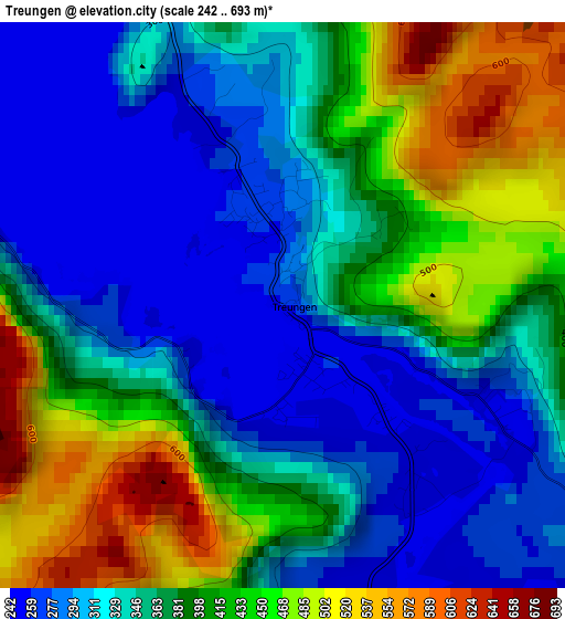
Below is the Elevation map of Treungen, which displays elevation range with different colors. Scale of the first map is from 242 to 693 m (794 to 2274 ft) with average elevation of 370.4 meters (=1215 ft) [note 1]
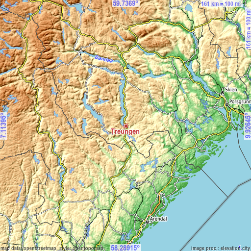
These maps also provides idea of topography and contour of this city, they are displayed at different zoom levels. More info about maps, scale and edge coordinates you can find below images.
| \ | Map #1 | Topo.Map |
| Scale [m] | 242..693 m | × |
| Scale [ft] | 794..2274 ft | × |
| Average | 370.4 m = 1215 ft | × |
| Width | 5.03 km = 3.1 mi | 161 km = 100 mi |
| Height | 5.03 km = 3.1 mi | 161 km = 100 mi |
| ↑Max Latitude | 59.043253° | 59.7369° |
| Latitude at center | 59.02064° | 59.02064° |
| ↓Min Latitude | 58.998013° | 58.28915° |
| ← Min Longitude | 8.476255° | 7.11395° |
| Longitude center | 8.5202° | 8.5202° |
| →Max Longitude | 8.564145° | 9.92645° |
Nearby cities:
Cities around Treungen sort by population:
• Risør elevation 9 m
52.9 km,  129°
129°
• Ulefoss 26 m
51.5 km,  55°
55°
• Tvedestrand 10 m
50.2 km,  151°
151°
• Lunde 81 m
45.3 km,  47°
47°
• Prestestranda 109 m
32 km,  74°
74°
• Seljord 133 m
52 km,  6°
6°
• Kviteseid 92 m
42.5 km,  357°
357°
• Åmli 164 m
28.4 km,  184°
184°
• Myra 176 m
36 km, 146°
• Fyresdal 295 m
30.4 km,  306°
306°
• Gjerstad 78 m
32.5 km,  118°
118°
• Bygland 207 m
46.7 km,  242°
242°
Multilingual:
 En español:
Treungen elevación 260 m.
 En France:
Treungen élévation 260 m.
 Auf Deutsch:
Treungen höhe über dem Meeresspiegel ist 260 m.

Sources and notes:
- [note 1] Map square and city borders are not equal. Map elevation data is calculated only from area inside that square.
- [src 1] Elevation data from geonames database provided with same terms of usage.
- [src 2] The elevation map of Treungen is generated using elevation data from NASA's 3 arcsec (90m) resolution SRTM data.
- [src 3] Base (background) map © OpenStreetMap contributors tiles are generated by Geofabrik and OpenTopoMap.
Copyright & License:
This Treungen Elevation Map is licensed under CC BY-SA. You may reuse any part from this page, if you give a proper credit by linking to this URL:
 More info on terms of use page.