Bygland elevation
Bygland (Aust-Agder), Norway elevation is 207 meters and Bygland elevation in feet is 679 ft above sea level [src 1]. Bygland is a seat of a second-order administrative division (feature code) with elevation that is 106 meters (348 ft) bigger than average city elevation in Norway.
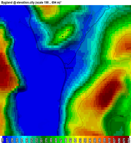
Below is the Elevation map of Bygland, which displays elevation range with different colors. Scale of the first map is from 198 to 694 m (650 to 2277 ft) with average elevation of 344.7 meters (=1131 ft) [note 1]
These maps also provides idea of topography and contour of this city, they are displayed at different zoom levels. More info about maps, scale and edge coordinates you can find below images.
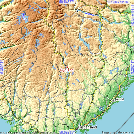
| \ | Map #1 | Topo.Map |
| Scale [m] | 198..694 m | × |
| Scale [ft] | 650..2277 ft | × |
| Average | 344.7 m = 1131 ft | × |
| Width | 5.06 km = 3.1 mi | 161.9 km = 100.6 mi |
| Height | 5.06 km = 3.1 mi | 161.9 km = 100.6 mi |
| ↑Max Latitude | 58.851239° | 59.54877° |
| Latitude at center | 58.8285° | 58.8285° |
| ↓Min Latitude | 58.805746° | 58.09295° |
| ← Min Longitude | 7.752215° | 6.38991° |
| Longitude center | 7.79616° | 7.79616° |
| →Max Longitude | 7.840105° | 9.20241° |
Nearby cities:
Cities around Bygland sort by population:
• Vennesla elevation 53 m
63.1 km,  170°
170°
• Birkeland 52 m
60.8 km,  155°
155°
• Åmli 164 m
40.2 km,  100°
100°
• Myra 176 m
62.1 km, 98°
• Fyresdal 295 m
42.9 km,  23°
23°
• Blakstad 56 m
60.9 km,  126°
126°
• Tingvatn 168 m
60.4 km,  213°
213°
• Treungen 260 m
46.7 km,  62°
62°
• Valle 319 m
45.2 km,  340°
340°
• Birketveit 233 m
41.7 km, 170°
• Kyrkjebygda 262 m
32.4 km,  222°
222°
• Evje 185 m
27 km,  179°
179°
Multilingual:
 En español:
Bygland elevación 207 m.
 En France:
Bygland élévation 207 m.


Sources and notes:
- [note 1] Map square and city borders are not equal. Map elevation data is calculated only from area inside that square.
- [src 1] Elevation data from geonames database provided with same terms of usage.
- [src 2] The elevation map of Bygland is generated using elevation data from NASA's 3 arcsec (90m) resolution SRTM data.
- [src 3] Base (background) map © OpenStreetMap contributors tiles are generated by Geofabrik and OpenTopoMap.
Copyright & License:
This Bygland Elevation Map is licensed under CC BY-SA. You may reuse any part from this page, if you give a proper credit by linking to this URL:
 More info on terms of use page.