Fyresdal elevation
Fyresdal (Telemark), Norway elevation is 295 meters and Fyresdal elevation in feet is 968 ft above sea level [src 1]. Fyresdal is a seat of a second-order administrative division (feature code) with elevation that is 194 meters (636 ft) bigger than average city elevation in Norway.
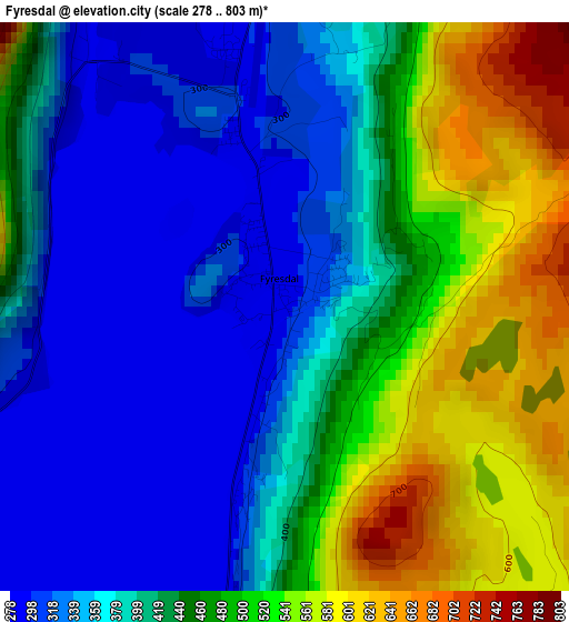
Below is the Elevation map of Fyresdal, which displays elevation range with different colors. Scale of the first map is from 278 to 803 m (912 to 2635 ft) with average elevation of 424.4 meters (=1392 ft) [note 1]
These maps also provides idea of topography and contour of this city, they are displayed at different zoom levels. More info about maps, scale and edge coordinates you can find below images.
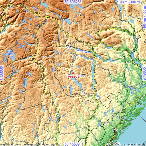
| \ | Map #1 | Topo.Map |
| Scale [m] | 278..803 m | × |
| Scale [ft] | 912..2635 ft | × |
| Average | 424.4 m = 1392 ft | × |
| Width | 5.01 km = 3.1 mi | 160.2 km = 99.5 mi |
| Height | 5.01 km = 3.1 mi | 160.2 km = 99.5 mi |
| ↑Max Latitude | 59.205935° | 59.89628° |
| Latitude at center | 59.18343° | 59.18343° |
| ↓Min Latitude | 59.16091° | 58.45539° |
| ← Min Longitude | 8.048155° | 6.68585° |
| Longitude center | 8.0921° | 8.0921° |
| →Max Longitude | 8.136045° | 9.49835° |
Nearby cities:
Cities around Fyresdal sort by population:
• Bø elevation 67 m
61.1 km,  65°
65°
• Lunde 81 m
58.9 km,  77°
77°
• Prestestranda 109 m
55.9 km,  99°
99°
• Seljord 133 m
45.3 km,  42°
42°
• Dalen 79 m
29.5 km,  350°
350°
• Kviteseid 92 m
33.3 km, 43°
• Åmli 164 m
51.6 km,  154°
154°
• Hovden 782 m
59.1 km,  315°
315°
• Åmot 471 m
43.4 km, 352°
• Bygland 207 m
42.9 km,  203°
203°
• Valle 319 m
31.9 km,  275°
275°
• Treungen 260 m
30.4 km,  126°
126°
Multilingual:
 En español:
Fyresdal elevación 295 m.
 En France:
Fyresdal élévation 295 m.
 Auf Deutsch:
Fyresdal höhe über dem Meeresspiegel ist 295 m.

Sources and notes:
- [note 1] Map square and city borders are not equal. Map elevation data is calculated only from area inside that square.
- [src 1] Elevation data from geonames database provided with same terms of usage.
- [src 2] The elevation map of Fyresdal is generated using elevation data from NASA's 3 arcsec (90m) resolution SRTM data.
- [src 3] Base (background) map © OpenStreetMap contributors tiles are generated by Geofabrik and OpenTopoMap.
Copyright & License:
This Fyresdal Elevation Map is licensed under CC BY-SA. You may reuse any part from this page, if you give a proper credit by linking to this URL:
 More info on terms of use page.