Risør elevation
Risør (Aust-Agder), Norway elevation is 9 meters and Risør elevation in feet is 30 ft above sea level [src 1]. Risør is a seat of a second-order administrative division (feature code) with elevation that is 92 meters (302 ft) smaller than average city elevation in Norway.
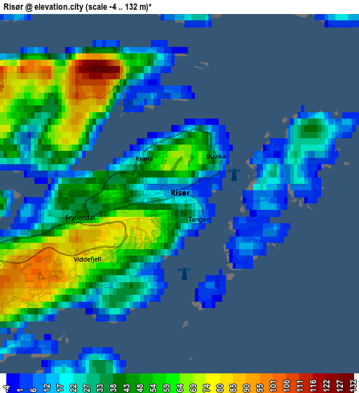
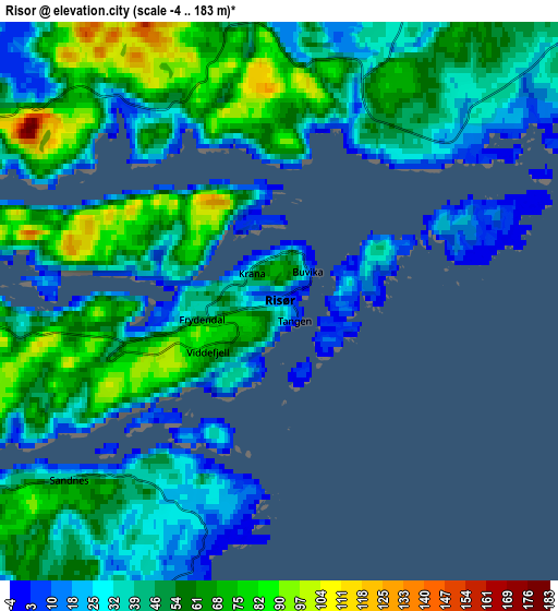
Below is the Elevation map of Risør, which displays elevation range with different colors. Scale of the first map is from -4 to 132 m (-13 to 433 ft) with average elevation of 39 meters (=128 ft) [note 1]
These maps also provides idea of topography and contour of this city, they are displayed at different zoom levels. More info about maps, scale and edge coordinates you can find below images.
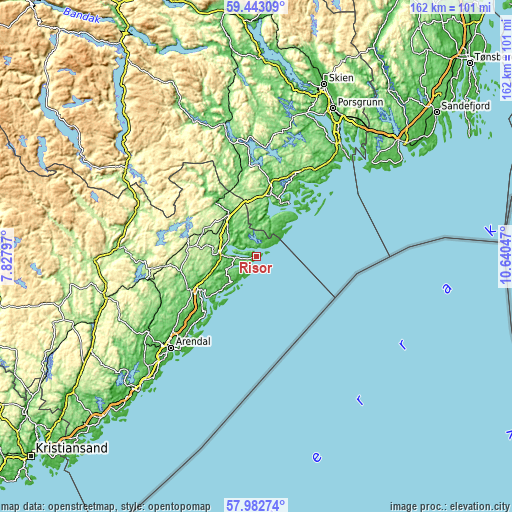
| \ | Map #1 | Map #2 | Topo.Map |
| Scale [m] | -4..132 m | -4..183 m | × |
| Scale [ft] | -13..433 ft | -13..600 ft | × |
| Average | 39 m = 128 ft | 47.9 m = 157 ft | × |
| Width | 5.07 km = 3.2 mi | 10.15 km = 6.3 mi | 162.4 km = 100.9 mi |
| Height | 5.07 km = 3.2 mi | 10.15 km = 6.3 mi | 162.4 km = 100.9 mi |
| ↑Max Latitude | 58.743379° | 58.766174° | 59.44309° |
| Latitude at center | 58.72057° | 58.72057° | 58.72057° |
| ↓Min Latitude | 58.697746° | 58.674906° | 57.98274° |
| ← Min Longitude | 9.190275° | 9.146329° | 7.82797° |
| Longitude center | 9.23422° | 9.23422° | 9.23422° |
| →Max Longitude | 9.278165° | 9.322111° | 10.64047° |
Nearby cities:
Cities around Risør sort by population:
• Porsgrunn elevation 9 m
52.6 km,  27°
27°
• Arendal 19 m
39.3 km,  222°
222°
• Kragerø 6 m
19.5 km, 32°
• Fevik 21 m
50 km, 220°
• Tvedestrand 10 m
20.6 km,  237°
237°
• Herre 12 m
46.6 km,  23°
23°
• Prestestranda 109 m
43.1 km,  346°
346°
• Åmli 164 m
43.6 km,  276°
276°
• Myra 176 m
21.7 km, 278°
• Gjerstad 78 m
21.7 km,  325°
325°
• Langesund 5 m
43 km,  43°
43°
• Blakstad 56 m
41.7 km,  234°
234°
Multilingual:
 En español:
Risør elevación 9 m.
 En France:
Risør élévation 9 m.


Sources and notes:
- [note 1] Map square and city borders are not equal. Map elevation data is calculated only from area inside that square.
- [src 1] Elevation data from geonames database provided with same terms of usage.
- [src 2] The elevation map of Risør is generated using elevation data from NASA's 3 arcsec (90m) resolution SRTM data.
- [src 3] Base (background) map © OpenStreetMap contributors tiles are generated by Geofabrik and OpenTopoMap.
Copyright & License:
This Risør Elevation Map is licensed under CC BY-SA. You may reuse any part from this page, if you give a proper credit by linking to this URL:
 More info on terms of use page.