Aboh elevation
Aboh (Imo, Aboh-Mbaise), Nigeria elevation is 139 meters and Aboh elevation in feet is 456 ft above sea level [src 1]. Aboh is a seat of a second-order administrative division (feature code) with elevation that is 158 meters (518 ft) smaller than average city elevation in Nigeria.
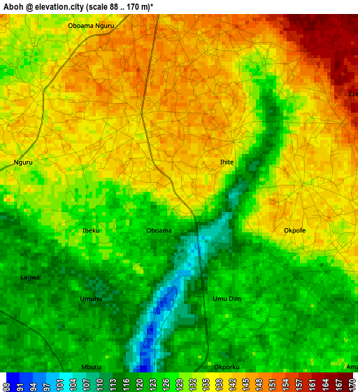
Below is the Elevation map of Aboh, which displays elevation range with different colors. Scale of the first map is from 88 to 170 m (289 to 558 ft) with average elevation of 131.5 meters (=431 ft) [note 1]
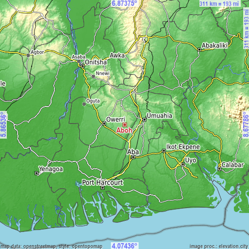
These maps also provides idea of topography and contour of this city, they are displayed at different zoom levels. More info about maps, scale and edge coordinates you can find below images.
| \ | Map #1 | Topo.Map |
| Scale [m] | 88..170 m | × |
| Scale [ft] | 289..558 ft | × |
| Average | 131.5 m = 431 ft | × |
| Width | 9.73 km = 6 mi | 311.3 km = 193.4 mi |
| Height | 9.73 km = 6 mi | 311.3 km = 193.4 mi |
| ↑Max Latitude | 5.519433° | 6.87375° |
| Latitude at center | 5.47569° | 5.47569° |
| ↓Min Latitude | 5.431944° | 4.07436° |
| ← Min Longitude | 7.227665° | 5.86536° |
| Longitude center | 7.27161° | 7.27161° |
| →Max Longitude | 7.315555° | 8.67786° |
Nearby cities:
Cities around Aboh sort by population:
• Umuahia elevation 148 m
25.3 km,  77°
77°
• Owerri 73 m
26.4 km,  271°
271°
• Orodo 138 m
30.7 km,  300°
300°
• Iho 149 m
22.5 km, 301°
• Nwaorieubi 115 m
30.6 km,  292°
292°
• Omoba 98 m
29.9 km,  150°
150°
• Umuelemai 147 m
23.8 km,  352°
352°
• Umuneke-Ngor 66 m
20.5 km,  220°
220°
• Okpuala-Ngwa 118 m
18.4 km,  135°
135°
• Isinweke 171 m
18.3 km,  28°
28°
• Afor-Oru 137 m
7.3 km,  357°
357°
• Itu 141 m
6.7 km,  101°
101°
Multilingual:
 En español:
Aboh elevación 139 m.
 En France:
Aboh élévation 139 m.


Sources and notes:
- [note 1] Map square and city borders are not equal. Map elevation data is calculated only from area inside that square.
- [src 1] Elevation data from geonames database provided with same terms of usage.
- [src 2] The elevation map of Aboh is generated using elevation data from NASA's 3 arcsec (90m) resolution SRTM data.
- [src 3] Base (background) map © OpenStreetMap contributors tiles are generated by Geofabrik and OpenTopoMap.
Copyright & License:
This Aboh Elevation Map is licensed under CC BY-SA. You may reuse any part from this page, if you give a proper credit by linking to this URL:
 More info on terms of use page.