Orodo elevation
Orodo (Imo, Mbatoli), Nigeria elevation is 138 meters and Orodo elevation in feet is 453 ft above sea level [src 1]. Orodo is a populated place (feature code) with elevation that is 159 meters (522 ft) smaller than average city elevation in Nigeria.
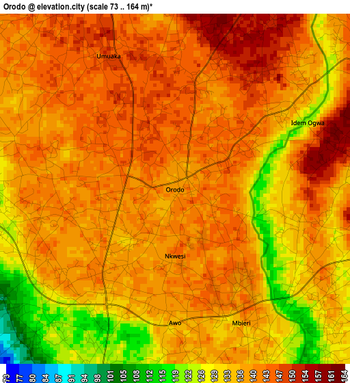
Below is the Elevation map of Orodo, which displays elevation range with different colors. Scale of the first map is from 73 to 164 m (240 to 538 ft) with average elevation of 137.1 meters (=450 ft) [note 1]
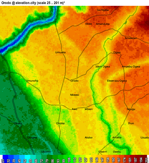
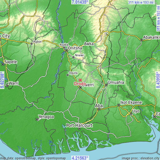
These maps also provides idea of topography and contour of this city, they are displayed at different zoom levels. More info about maps, scale and edge coordinates you can find below images.
| \ | Map #1 | Map #2 | Topo.Map |
| Scale [m] | 73..164 m | 25..201 m | × |
| Scale [ft] | 240..538 ft | 82..659 ft | × |
| Average | 137.1 m = 450 ft | 129.1 m = 424 ft | × |
| Width | 9.73 km = 6 mi | 19.45 km = 12.1 mi | 311.2 km = 193.4 mi |
| Height | 9.73 km = 6 mi | 19.45 km = 12.1 mi | 311.2 km = 193.4 mi |
| ↑Max Latitude | 5.660403° | 5.704132° | 7.01435° |
| Latitude at center | 5.61667° | 5.61667° | 5.61667° |
| ↓Min Latitude | 5.572934° | 5.529195° | 4.21563° |
| ← Min Longitude | 6.989385° | 6.945439° | 5.62708° |
| Longitude center | 7.03333° | 7.03333° | 7.03333° |
| →Max Longitude | 7.077275° | 7.121221° | 8.43958° |
Nearby cities:
Cities around Orodo sort by population:
• Owerri elevation 73 m
14.8 km,  180°
180°
• Nkwerre 179 m
17.7 km,  26°
26°
• Orlu 173 m
19.9 km,  0°
0°
• Iho 149 m
8.2 km,  117°
117°
• Dikenafai 166 m
21.7 km,  38°
38°
• Mgbidi 72 m
20.5 km,  308°
308°
• Umumma 136 m
18.3 km,  328°
328°
• Umuguma 63 m
18.2 km,  204°
204°
• Amaigbo 171 m
15.5 km, 35°
• Nnenasa 156 m
13.1 km,  350°
350°
• Umundugba 157 m
7.9 km, 32°
• Nwaorieubi 115 m
4.3 km,  205°
205°
Multilingual:
 En español:
Orodo elevación 138 m.
 En France:
Orodo élévation 138 m.


Sources and notes:
- [note 1] Map square and city borders are not equal. Map elevation data is calculated only from area inside that square.
- [src 1] Elevation data from geonames database provided with same terms of usage.
- [src 2] The elevation map of Orodo is generated using elevation data from NASA's 3 arcsec (90m) resolution SRTM data.
- [src 3] Base (background) map © OpenStreetMap contributors tiles are generated by Geofabrik and OpenTopoMap.
Copyright & License:
This Orodo Elevation Map is licensed under CC BY-SA. You may reuse any part from this page, if you give a proper credit by linking to this URL:
 More info on terms of use page.