Enugu elevation
Enugu, Nigeria elevation is 192 meters and Enugu elevation in feet is 630 ft above sea level [src 1]. Enugu is a seat of a first-order administrative division (feature code) with elevation that is 105 meters (344 ft) smaller than average city elevation in Nigeria.
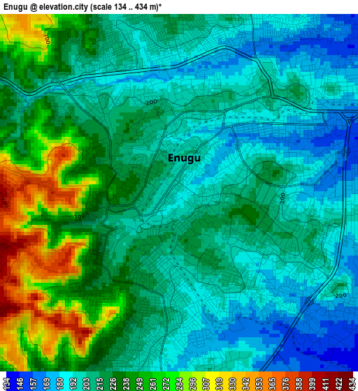
Below is the Elevation map of Enugu, which displays elevation range with different colors. Scale of the first map is from 134 to 434 m (440 to 1424 ft) with average elevation of 219 meters (=719 ft) [note 1]
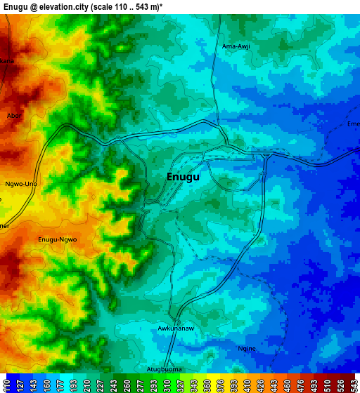
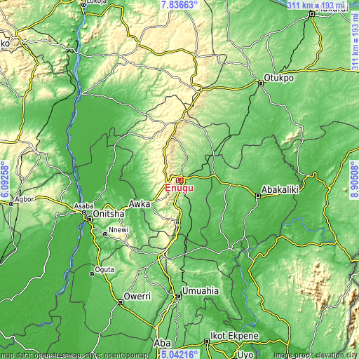
These maps also provides idea of topography and contour of this city, they are displayed at different zoom levels. More info about maps, scale and edge coordinates you can find below images.
| \ | Map #1 | Map #2 | Topo.Map |
| Scale [m] | 134..434 m | 110..543 m | × |
| Scale [ft] | 440..1424 ft | 361..1781 ft | × |
| Average | 219 m = 719 ft | 238 m = 781 ft | × |
| Width | 9.71 km = 6 mi | 19.42 km = 12.1 mi | 310.7 km = 193.1 mi |
| Height | 9.71 km = 6 mi | 19.42 km = 12.1 mi | 310.7 km = 193.1 mi |
| ↑Max Latitude | 6.484986° | 6.528648° | 7.83663° |
| Latitude at center | 6.44132° | 6.44132° | 6.44132° |
| ↓Min Latitude | 6.39765° | 6.353977° | 5.04216° |
| ← Min Longitude | 7.454885° | 7.410939° | 6.09258° |
| Longitude center | 7.49883° | 7.49883° | 7.49883° |
| →Max Longitude | 7.542775° | 7.586721° | 8.90508° |
Nearby cities:
Cities around Enugu sort by population:
• Aku elevation 299 m
35.8 km,  326°
326°
• Eha Amufu 109 m
37.6 km,  49°
49°
• Udi 437 m
16.4 km,  211°
211°
• Opi 496 m
38.6 km,  349°
349°
• Amagunze 92 m
21 km,  125°
125°
• Mberubu 82 m
33.2 km,  154°
154°
• Ezillo 71 m
35.3 km,  92°
92°
• Oji River 74 m
32.6 km,  230°
230°
• Ogbede 361 m
29.2 km, 331°
• Aguobu-Owa 200 m
26.2 km,  252°
252°
• Agbani 151 m
15.9 km,  159°
159°
• Nkwo Nike 173 m
7.6 km,  9°
9°
Multilingual:
 En español:
Enugu elevación 192 m.
 En France:
Enugu élévation 192 m.


Sources and notes:
- [note 1] Map square and city borders are not equal. Map elevation data is calculated only from area inside that square.
- [src 1] Elevation data from geonames database provided with same terms of usage.
- [src 2] The elevation map of Enugu is generated using elevation data from NASA's 3 arcsec (90m) resolution SRTM data.
- [src 3] Base (background) map © OpenStreetMap contributors tiles are generated by Geofabrik and OpenTopoMap.
Copyright & License:
This Enugu Elevation Map is licensed under CC BY-SA. You may reuse any part from this page, if you give a proper credit by linking to this URL:
 More info on terms of use page.