Gorgoram elevation
Gorgoram (Yobe, Jakusko), Nigeria elevation is 348 meters and Gorgoram elevation in feet is 1142 ft above sea level [src 1]. Gorgoram is a populated place (feature code) with elevation that is 51 meters (167 ft) bigger than average city elevation in Nigeria.
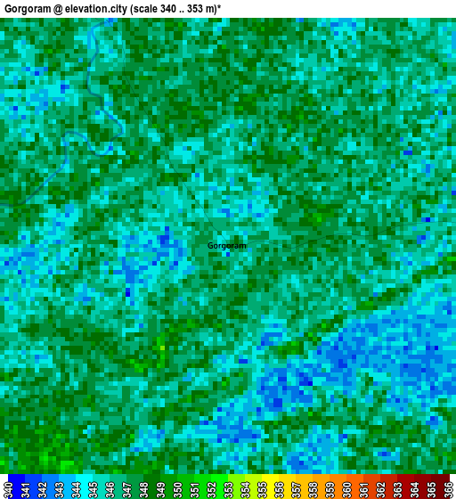
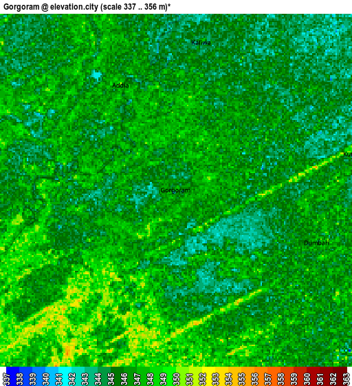
Below is the Elevation map of Gorgoram, which displays elevation range with different colors. Scale of the first map is from 340 to 353 m (1115 to 1158 ft) with average elevation of 345.9 meters (=1135 ft) [note 1]
These maps also provides idea of topography and contour of this city, they are displayed at different zoom levels. More info about maps, scale and edge coordinates you can find below images.
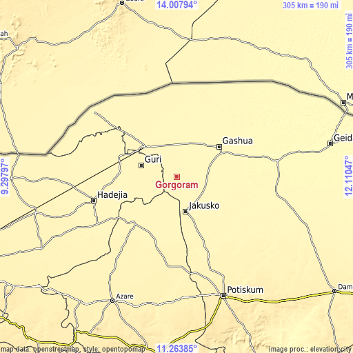
| \ | Map #1 | Map #2 | Topo.Map |
| Scale [m] | 340..353 m | 337..356 m | × |
| Scale [ft] | 1115..1158 ft | 1106..1168 ft | × |
| Average | 345.9 m = 1135 ft | 346 m = 1135 ft | × |
| Width | 9.54 km = 5.9 mi | 19.07 km = 11.8 mi | 305.1 km = 189.6 mi |
| Height | 9.54 km = 5.9 mi | 19.07 km = 11.8 mi | 305.1 km = 189.6 mi |
| ↑Max Latitude | 12.682457° | 12.725326° | 14.00794° |
| Latitude at center | 12.63958° | 12.63958° | 12.63958° |
| ↓Min Latitude | 12.596696° | 12.553805° | 11.26385° |
| ← Min Longitude | 10.660275° | 10.616329° | 9.29797° |
| Longitude center | 10.70422° | 10.70422° | 10.70422° |
| →Max Longitude | 10.748165° | 10.792111° | 12.11047° |
Nearby cities:
Cities around Gorgoram sort by population:
• Gashua elevation 339 m
44.8 km,  54°
54°
• Nguru 349 m
37.7 km,  314°
314°
• Hadejia 359 m
74.9 km,  253°
253°
• Kumagunnam 346 m
57.8 km,  352°
352°
• Gamawa 364 m
59.1 km,  197°
197°
• Katagum 362 m
55 km,  224°
224°
• Birniwa 353 m
53.5 km,  288°
288°
• Gwio Kura 342 m
39.5 km,  84°
84°
• Kiri Kasamma 354 m
49.1 km,  276°
276°
• Guri 354 m
32.4 km, 287°
• Jajimaji 342 m
30.9 km,  21°
21°
• Jakusko 352 m
30.8 km,  165°
165°
Multilingual:
 En español:
Gorgoram elevación 348 m.
 En France:
Gorgoram élévation 348 m.
 Auf Deutsch:
Gorgoram höhe über dem Meeresspiegel ist 348 m.

Sources and notes:
- [note 1] Map square and city borders are not equal. Map elevation data is calculated only from area inside that square.
- [src 1] Elevation data from geonames database provided with same terms of usage.
- [src 2] The elevation map of Gorgoram is generated using elevation data from NASA's 3 arcsec (90m) resolution SRTM data.
- [src 3] Base (background) map © OpenStreetMap contributors tiles are generated by Geofabrik and OpenTopoMap.
Copyright & License:
This Gorgoram Elevation Map is licensed under CC BY-SA. You may reuse any part from this page, if you give a proper credit by linking to this URL:
 More info on terms of use page.