Gwagwalada elevation
Gwagwalada (FCT), Nigeria elevation is 186 meters and Gwagwalada elevation in feet is 610 ft above sea level [src 1]. Gwagwalada is a seat of a second-order administrative division (feature code) with elevation that is 111 meters (364 ft) smaller than average city elevation in Nigeria.
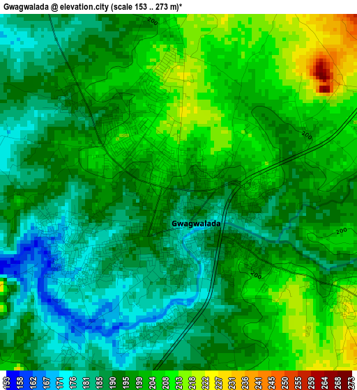
Below is the Elevation map of Gwagwalada, which displays elevation range with different colors. Scale of the first map is from 153 to 273 m (502 to 896 ft) with average elevation of 195.7 meters (=642 ft) [note 1]
These maps also provides idea of topography and contour of this city, they are displayed at different zoom levels. More info about maps, scale and edge coordinates you can find below images.
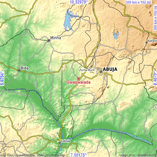
| \ | Map #1 | Topo.Map |
| Scale [m] | 153..273 m | × |
| Scale [ft] | 502..896 ft | × |
| Average | 195.7 m = 642 ft | × |
| Width | 9.65 km = 6 mi | 308.9 km = 191.9 mi |
| Height | 9.65 km = 6 mi | 308.9 km = 191.9 mi |
| ↑Max Latitude | 8.986828° | 10.32979° |
| Latitude at center | 8.94342° | 8.94342° |
| ↓Min Latitude | 8.900006° | 7.55175° |
| ← Min Longitude | 7.037705° | 5.6754° |
| Longitude center | 7.08165° | 7.08165° |
| →Max Longitude | 7.125595° | 8.4879° |
Nearby cities:
Cities around Gwagwalada sort by population:
• Abuja elevation 476 m
47.2 km,  74°
74°
• Suleja 421 m
28.5 km,  22°
22°
• Kuje 300 m
17.5 km,  113°
113°
• Lapai 169 m
57.2 km,  281°
281°
• Madala 416 m
23 km,  38°
38°
• Buga 187 m
57.9 km,  150°
150°
• Kwali 197 m
9.6 km,  226°
226°
• Toto 140 m
61.8 km,  180°
180°
• Abaji 138 m
54.4 km,  196°
196°
• Bwari 567 m
49.8 km, 41°
• Sabon Wuse 526 m
47.7 km, 24°
• Gawu Babangida 290 m
38.5 km,  345°
345°
Multilingual:
 En español:
Gwagwalada elevación 186 m.
 En France:
Gwagwalada élévation 186 m.
 Auf Deutsch:
Gwagwalada höhe über dem Meeresspiegel ist 186 m.

Sources and notes:
- [note 1] Map square and city borders are not equal. Map elevation data is calculated only from area inside that square.
- [src 1] Elevation data from geonames database provided with same terms of usage.
- [src 2] The elevation map of Gwagwalada is generated using elevation data from NASA's 3 arcsec (90m) resolution SRTM data.
- [src 3] Base (background) map © OpenStreetMap contributors tiles are generated by Geofabrik and OpenTopoMap.
Copyright & License:
This Gwagwalada Elevation Map is licensed under CC BY-SA. You may reuse any part from this page, if you give a proper credit by linking to this URL:
 More info on terms of use page.