Kuje elevation
Kuje (FCT), Nigeria elevation is 300 meters and Kuje elevation in feet is 984 ft above sea level [src 1]. Kuje is a seat of a second-order administrative division (feature code) with elevation that is 3 meters (10 ft) bigger than average city elevation in Nigeria.
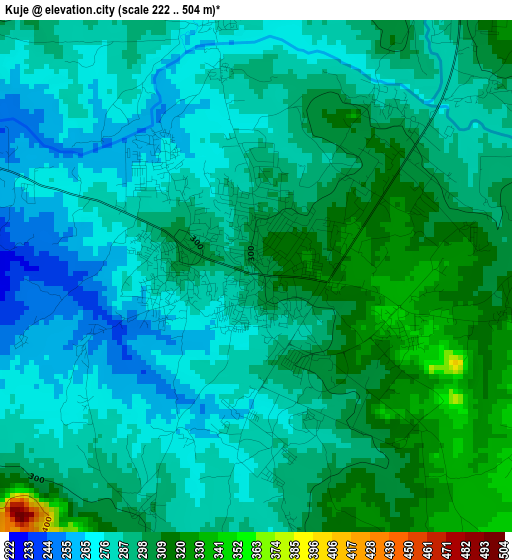
Below is the Elevation map of Kuje, which displays elevation range with different colors. Scale of the first map is from 222 to 504 m (728 to 1654 ft) with average elevation of 290.9 meters (=954 ft) [note 1]
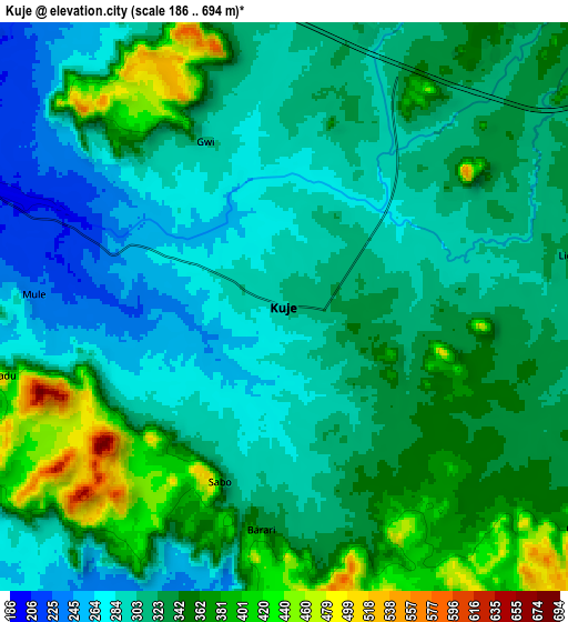
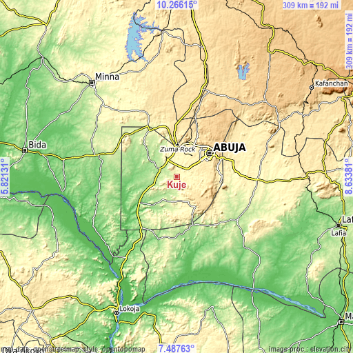
These maps also provides idea of topography and contour of this city, they are displayed at different zoom levels. More info about maps, scale and edge coordinates you can find below images.
| \ | Map #1 | Map #2 | Topo.Map |
| Scale [m] | 222..504 m | 186..694 m | × |
| Scale [ft] | 728..1654 ft | 610..2277 ft | × |
| Average | 290.9 m = 954 ft | 326.4 m = 1071 ft | × |
| Width | 9.66 km = 6 mi | 19.31 km = 12 mi | 308.9 km = 191.9 mi |
| Height | 9.66 km = 6 mi | 19.31 km = 12 mi | 309 km = 192 mi |
| ↑Max Latitude | 8.922936° | 8.966347° | 10.26615° |
| Latitude at center | 8.87952° | 8.87952° | 8.87952° |
| ↓Min Latitude | 8.836099° | 8.792672° | 7.48763° |
| ← Min Longitude | 7.183615° | 7.139669° | 5.82131° |
| Longitude center | 7.22756° | 7.22756° | 7.22756° |
| →Max Longitude | 7.271505° | 7.315451° | 8.63381° |
Nearby cities:
Cities around Kuje sort by population:
• Abuja elevation 476 m
35.4 km,  55°
55°
• Suleja 421 m
33.9 km,  351°
351°
• Madala 416 m
25.1 km,  356°
356°
• Buga 187 m
45 km,  163°
163°
• Kwali 197 m
23 km,  271°
271°
• Toto 140 m
57.1 km,  196°
196°
• Abaji 138 m
54.8 km,  214°
214°
• Gawu Babangida 290 m
51.3 km,  329°
329°
• Sabon Wuse 526 m
50.7 km,  4°
4°
• Karu 390 m
49.8 km,  73°
73°
• Bwari 567 m
47.6 km,  20°
20°
• Gwagwalada 186 m
17.5 km,  293°
293°
Multilingual:
 En español:
Kuje elevación 300 m.
 En France:
Kuje élévation 300 m.


Sources and notes:
- [note 1] Map square and city borders are not equal. Map elevation data is calculated only from area inside that square.
- [src 1] Elevation data from geonames database provided with same terms of usage.
- [src 2] The elevation map of Kuje is generated using elevation data from NASA's 3 arcsec (90m) resolution SRTM data.
- [src 3] Base (background) map © OpenStreetMap contributors tiles are generated by Geofabrik and OpenTopoMap.
Copyright & License:
This Kuje Elevation Map is licensed under CC BY-SA. You may reuse any part from this page, if you give a proper credit by linking to this URL:
 More info on terms of use page.