Gwarzo elevation
Gwarzo (Kano), Nigeria elevation is 581 meters and Gwarzo elevation in feet is 1906 ft above sea level [src 1]. Gwarzo is a seat of a second-order administrative division (feature code) with elevation that is 284 meters (932 ft) bigger than average city elevation in Nigeria.
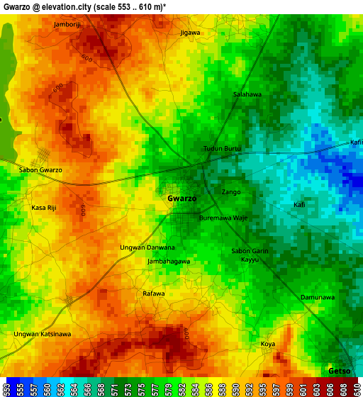
Below is the Elevation map of Gwarzo, which displays elevation range with different colors. Scale of the first map is from 553 to 610 m (1814 to 2001 ft) with average elevation of 583.3 meters (=1914 ft) [note 1]
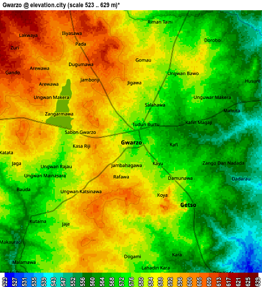
These maps also provides idea of topography and contour of this city, they are displayed at different zoom levels. More info about maps, scale and edge coordinates you can find below images.
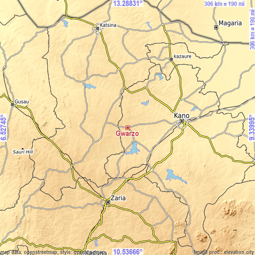
| \ | Map #1 | Map #2 | Topo.Map |
| Scale [m] | 553..610 m | 523..629 m | × |
| Scale [ft] | 1814..2001 ft | 1716..2064 ft | × |
| Average | 583.3 m = 1914 ft | 579.1 m = 1900 ft | × |
| Width | 9.56 km = 5.9 mi | 19.12 km = 11.9 mi | 306 km = 190.1 mi |
| Height | 9.56 km = 5.9 mi | 19.12 km = 11.9 mi | 306 km = 190.1 mi |
| ↑Max Latitude | 11.958965° | 12.001953° | 13.28831° |
| Latitude at center | 11.91597° | 11.91597° | 11.91597° |
| ↓Min Latitude | 11.872968° | 11.82996° | 10.53666° |
| ← Min Longitude | 7.889755° | 7.845809° | 6.52745° |
| Longitude center | 7.9337° | 7.9337° | 7.9337° |
| →Max Longitude | 7.977645° | 8.021591° | 9.33995° |
Nearby cities:
Cities around Gwarzo sort by population:
• Malumfashi elevation 618 m
36.9 km,  247°
247°
• Musawa 578 m
37.2 km,  309°
309°
• Jikamshi 565 m
33.5 km,  328°
328°
• Gora 593 m
29.2 km,  269°
269°
• Tofa 501 m
40.1 km,  66°
66°
• Kafur 587 m
40 km,  221°
221°
• Bagwai 518 m
34.7 km,  39°
39°
• Rimin Gado 521 m
34.6 km,  80°
80°
• Kiru 524 m
32.3 km,  137°
137°
• Kabo 510 m
26.6 km,  104°
104°
• Karaye 542 m
17.2 km,  148°
148°
• Shanono 584 m
16.4 km,  22°
22°
Multilingual:
 En español:
Gwarzo elevación 581 m.
 En France:
Gwarzo élévation 581 m.


Sources and notes:
- [note 1] Map square and city borders are not equal. Map elevation data is calculated only from area inside that square.
- [src 1] Elevation data from geonames database provided with same terms of usage.
- [src 2] The elevation map of Gwarzo is generated using elevation data from NASA's 3 arcsec (90m) resolution SRTM data.
- [src 3] Base (background) map © OpenStreetMap contributors tiles are generated by Geofabrik and OpenTopoMap.
Copyright & License:
This Gwarzo Elevation Map is licensed under CC BY-SA. You may reuse any part from this page, if you give a proper credit by linking to this URL:
 More info on terms of use page.