Malumfashi elevation
Malumfashi (Katsina), Nigeria elevation is 618 meters and Malumfashi elevation in feet is 2028 ft above sea level [src 1]. Malumfashi is a seat of a second-order administrative division (feature code) with elevation that is 321 meters (1053 ft) bigger than average city elevation in Nigeria.
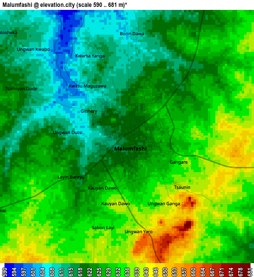
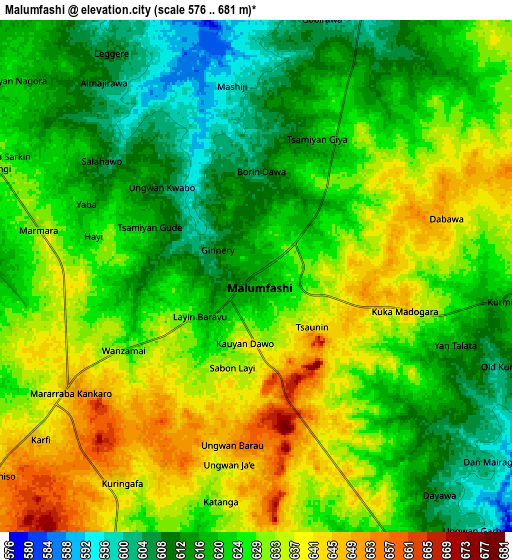
Below is the Elevation map of Malumfashi, which displays elevation range with different colors. Scale of the first map is from 590 to 681 m (1936 to 2234 ft) with average elevation of 625.6 meters (=2052 ft) [note 1]
These maps also provides idea of topography and contour of this city, they are displayed at different zoom levels. More info about maps, scale and edge coordinates you can find below images.
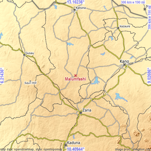
| \ | Map #1 | Map #2 | Topo.Map |
| Scale [m] | 590..681 m | 576..681 m | × |
| Scale [ft] | 1936..2234 ft | 1890..2234 ft | × |
| Average | 625.6 m = 2052 ft | 625.5 m = 2052 ft | × |
| Width | 9.57 km = 5.9 mi | 19.13 km = 11.9 mi | 306.1 km = 190.2 mi |
| Height | 9.57 km = 5.9 mi | 19.13 km = 11.9 mi | 306.1 km = 190.2 mi |
| ↑Max Latitude | 11.832365° | 11.875373° | 13.16236° |
| Latitude at center | 11.78935° | 11.78935° | 11.78935° |
| ↓Min Latitude | 11.746328° | 11.7033° | 10.40944° |
| ← Min Longitude | 7.576665° | 7.532719° | 6.21436° |
| Longitude center | 7.62061° | 7.62061° | 7.62061° |
| →Max Longitude | 7.664555° | 7.708501° | 9.02686° |
Nearby cities:
Cities around Malumfashi sort by population:
• Funtua elevation 709 m
44.8 km,  228°
228°
• Gwarzo 581 m
36.9 km,  67°
67°
• Bakori 656 m
33.7 km,  219°
219°
• Danja 681 m
46.3 km,  188°
188°
• Kankara 595 m
27.7 km,  304°
304°
• Musawa 578 m
38.2 km,  8°
8°
• Jikamshi 565 m
45.8 km,  21°
21°
• Gora 593 m
14.6 km, 19°
• Shanono 584 m
49.8 km,  54°
54°
• Karaye 542 m
42.9 km,  90°
90°
• Rogo 611 m
34.3 km,  140°
140°
• Kafur 587 m
17.7 km,  154°
154°
Multilingual:
 En español:
Malumfashi elevación 618 m.
 En France:
Malumfashi élévation 618 m.
 Auf Deutsch:
Malumfashi höhe über dem Meeresspiegel ist 618 m.

Sources and notes:
- [note 1] Map square and city borders are not equal. Map elevation data is calculated only from area inside that square.
- [src 1] Elevation data from geonames database provided with same terms of usage.
- [src 2] The elevation map of Malumfashi is generated using elevation data from NASA's 3 arcsec (90m) resolution SRTM data.
- [src 3] Base (background) map © OpenStreetMap contributors tiles are generated by Geofabrik and OpenTopoMap.
Copyright & License:
This Malumfashi Elevation Map is licensed under CC BY-SA. You may reuse any part from this page, if you give a proper credit by linking to this URL:
 More info on terms of use page.